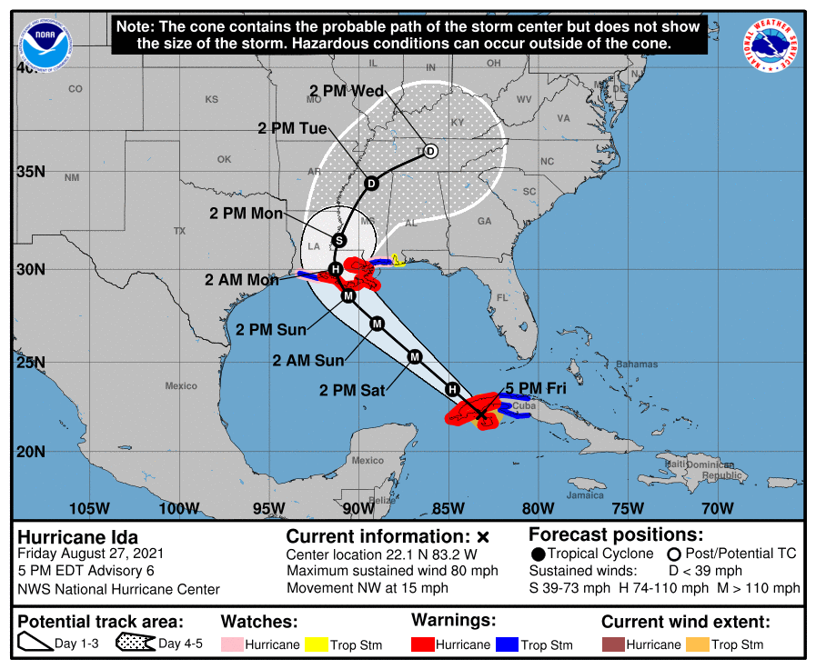
Hurricane Ida has strengthened significantly today, going from barely tropical storm status to a Category 1 hurricane with 80-mph sustained winds. Unfortunately, there is little to inhibit further strengthening this weekend. After Ida moves across Cuba tonight, the combination of low wind shear, a moist atmosphere, and blazing hot Gulf of Mexico sea temperatures are ideal for rapid intensification. For this reason, the latest National Hurricane Center forecast brings Ida to a Category 4 major hurricane before landfall along the central Louisiana coast on Sunday afternoon. Confidence is very high in this track.
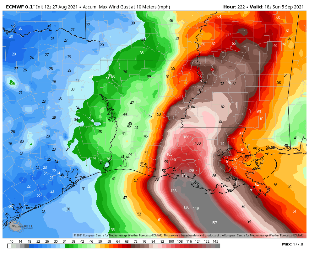
This post will address what such a storm will actually mean for people on the ground. First up is a forecast for “wind gusts.” This is different than sustained winds, which are how forecaster define the intensity of a storm. But gusts are an appropriate measure of maximum winds. Here’s a forecast for the swath of highest gusts from Ida. It is not gospel, but it offers a good approximation of what to expect, where. There will be major structure damage and widespread power outages.
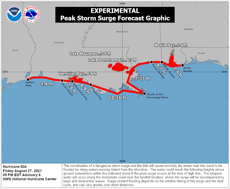
The next threat from a hurricane like Ida is storm surge. The graphic below from the National Hurricane Center is the best estimate for the combination of surge and tide above normal water levels. Ida will bring a dangerous storm surge to the Mississippi River delta area, and parts of New Orleans not behind the levee system.
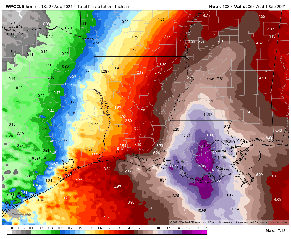
The final major threat from a hurricane like Ida is inland rainfall. The storm is going to keep moving, but it will slow a little as it approaches the coast and moves inland. This should allow for some areas of southeastern Louisiana to experience 10 to 20 inches of rainfall, which will be falling on top of a significant storm surge. These are dangerous amounts of water for unprotected areas.
There is not much of a silver lining for this storm, which is set up to deliver a gut punch to the state of Louisiana. The only thing we can offer is that the western part of the state—including Lake Charles—that was pummeled during the 2020 hurricane season should escape the worst of Ida. After this storm moves away from New Orleans later on Monday and Tuesday it will be time to help. That is something the generous people of Houston are very good at.
Matt or I will have an update on Saturday before noon.
16 years to the day after Katrina….
wow just heartbreaking…
Praying for all in the path of Ida!
Pretty solemn post from you guys. Praying for those in the path of this storm.
Please let us know how we can help our neighbors in one of your next few posts. Sometimes it’s hard to know how one person can help in such a disaster. Thank you!
A few guys I used to work with volunteer with the Cajun Navy. They are getting themselves ready for Ida. Theses guys did amazing work during Harvey.
https://www.facebook.com/1253932804631023/posts/4606254536065483/?app=fbl
MAKE SURE THE CAJUN NAVY YOU DONATE TO IS A 501c3 ORGANIZATION. There are several with similar names and there is one that I cannot recommend donating to. Please do some basic checking first. But yes, an organization like this is a good option to support.
Catholic Charites provides emergency assistance to people of all faiths or no faith, with very low overhead and administrative costs: https://www.google.com/search?gs_ssp=eJzj4tZP1zcsyUqPLyyyNGC0UjWosDAzMkhKTDIwhQIrgwpTsxQTS5MUIyBISrRMMfSSS04sycjPyUxWSM5ILMosyUwtVshLLVfIL8pJTcwrBgD4UBnp&q=catholic+charities+new+orleans&oq=catholic+charities+new+orleans&aqs=chrome.1.69i57j46i175i199i512j0i512l6.13808j0j7&sourceid=chrome&ie=UTF-8
We just put our son who is a student at Tulane on a plane out of New Orleans. It’s a scary storm.
I hope the Cajun Navy is set to rescue those that will need it. I doubt everyone will evacuate, but it would be great if the majority of people do. Hopefully they’ve already set up evacuation shelters away from the storm for those that get out while the gettings good.
How does this storm seem to compare to Katrina in terms of track and probable intensity?
Track is a little East of where Katrina made landfall and I believe Katrina weakened to a Cat 3 just before landfall
https://en.wikipedia.org/wiki/Hurricane_Katrina#/media/File:Katrina_2005_track.png
West, you mean?
Now is also the time to help as well. If you have room in your home for those feeling this catastrophe, reach out.
Any worry about the Euro and UK models shifting west on the latest update? Those are usually the most reliable models.
Dear Friends in NOLA saying the cone has moved west of them. Your thoughts please ASAP!
Thank you for being there for us.
It has not. NHC’s 7am track isn’t significantly changed from 12 hours ago.
I hope Louisiana residents heed the warning to evacuate now. Although confidence is high in the current storm track, it still bears watching to ensure it doesn’t unexpectedly track more to the west. Thank you for the update.
0115hrs
8/28/21
Kingwood
Thx for this excellent report. I a long time subscriber but my IT skills “suck canal water” as we use to say over in AnahuacTx 25′ above MSL.
Prayers and hopes for our La. friends.
All the Best