Good Saturday morning. Ida is strengthening steadily this morning as it moves into the heart of the exceptionally warm Gulf waters between Cuba and Louisiana. Not much has changed since yesterday in terms of the forecast track or, unfortunately, forecast intensity.
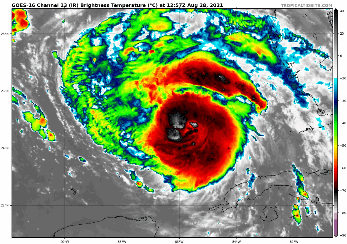
If you look at the satellite loop above, Hurricane Ida’s eye is emerging, indicated by the little green “dot” in the middle of the storm, an indication that the system is strengthening.
Unfortunately, very little has changed since yesterday. The track is essentially unchanged, with the National Hurricane Center predicting a track toward Morgan City, LA, with a little wiggle room on either side.
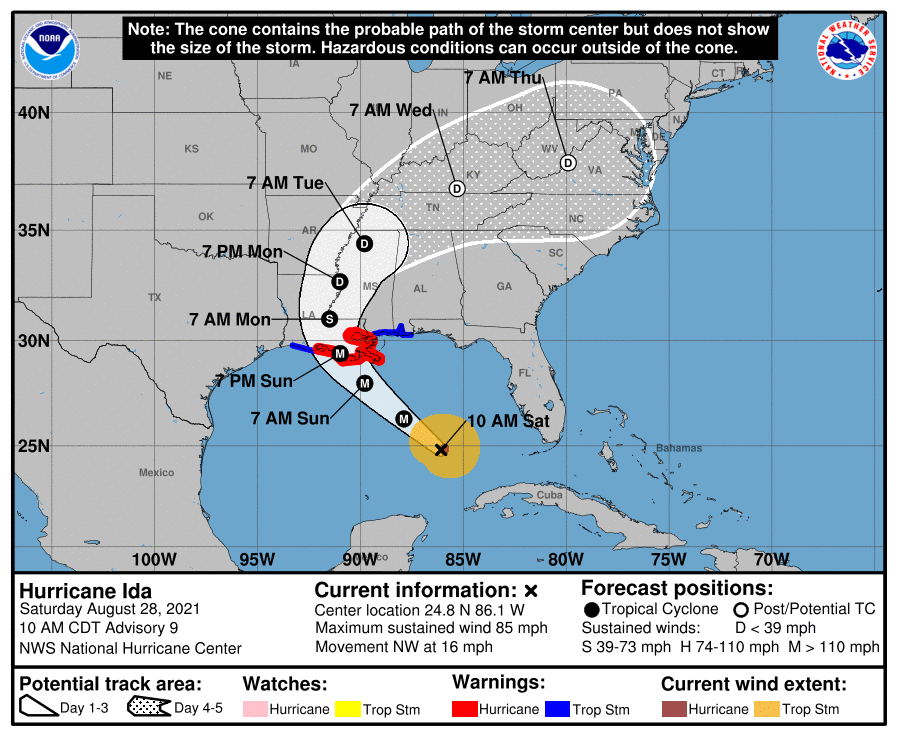
The intensity forecast is mostly unchanged as well, with modeling implying that a major (category 3 or 4) hurricane is almost certainly going to be what makes landfall. At this point, folks along the eastern Louisiana coast should be preparing for significant hurricane impacts.
Storm surge values are mostly unchanged today too,
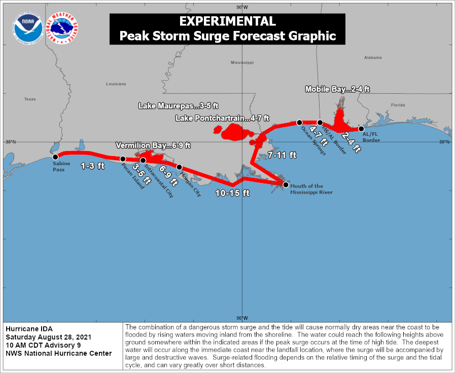
A significant 10 to 15 foot surge is possible between Morgan City, Grand Isle, and the mouth of the Mississippi River. Slightly lower values can be expected just southeast of New Orleans. It is tempting to compare Ida with Katrina, but there are a number of differences from track to intensity to size. For New Orleans, in Katrina, winds were out of the east and then out of the north. With Ida, winds will be out of the southeast most of the time, which means different impacts this time around. Hopefully far less severe, particularly given the distance of landfall from the city. But it’s obviously much too close for comfort.
In addition to the wind and surge, as we’ve noted Ida will have a ton of moisture as it comes ashore. This will lead to significant rainfall and probably freshwater flooding issues all across eastern Louisiana and Mississippi.
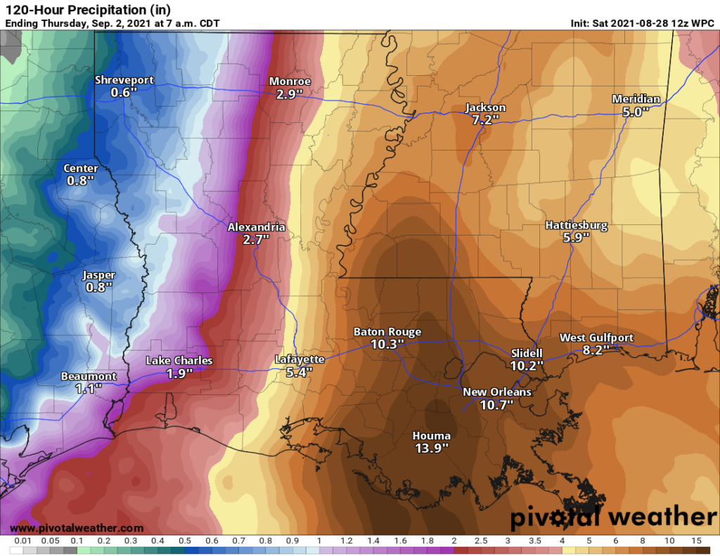
Maximum totals of 10 to 15 inches will be possible along and east of where Ida comes ashore, leading to significant flash flooding and river and bayou flooding in eastern Louisiana. Significant flash flooding issues will likely continue as Ida lifts north into Mississippi as well.
All in all, Ida will be a very, very serious storm for our neighbors to the east, and our thoughts are with them.
Local update
Just a quick local update for the weekend. Scattered showers or thunderstorms will be possible today. We expect coverage to diminish tomorrow, so less chance of rain. And even less chance of rain is with us on Monday. Look for temperatures in the low-90s today and mid-90s tomorrow. Mid, if not upper-90s will be possible on Monday. Winds here should be out of the north or west after tomorrow and be no worse than 10 to 15 mph or so. Some minor runup is possible along the coast with rough surf and strong rip currents, so exercise caution if you’ll be swimming tomorrow or Monday.
Barring any significant changes with Ida, Eric will have our next update on Sunday morning.
My thoughts are with Louisiana…On that note, I was wondering about the disturbance I’ve heard chatter about for hitting the Gulf next weekend, Labor Day..Any thoughts if it will develop at all or follow a similar path?
A Foot Above is an awesome foundation, and I know the woman who started it personally. I can attest that every dollar or item donates goes straight to the people in need. https://www.footabove.org/
Our thoughts are with Louisiana. If y’all (or other readers) know of reputable relief efforts where we can donate, please give them a shoutout. LA does a lot for Houston when we have storms and we’d love to give back.
Salvation Army is one of the best
Cajun Navy did so much for us during Harvey, I donate a lot to them. Check out their page on FB.
Dawn, which on? I was thinking the same and. Seem to have found a few different ones. I Want to help but want to make sure it gets in the right hands. TIA.
I work outdoors, and it seems to me that this singer has been really mild. I don’t recall a day that it was really excessively hot all summer.
I don’t know if this is the case for everyone, but for me on two different devices, this update only showed when I clicked the Twitter link, and not from navigating to the main/home page – just a heads-up, if that is unintentional. Praying for Louisiana, and thank you for all you do!
You’ve probably addressed this somewhere already, but doesn’t it seem like Louisiana gets more than its fair share of hurricanes, major hurricanes? I am sure it’s about steering currents and highs and lows, but seems like a lot go to LA.
To All
Pray for the families that have to experience Ida.
God Bless them and protect them…Amen
I agree, Cajun Navy for donations..Not only do they rescue, but they often find and distribute essentials to the people hard hit.