Good morning. After Wednesday evening’s surprise storms, the majority of power outages reported due to damaging winds has dropped considerably as crews have worked overnight. The main area of concern remains in Montgomery County, where about 25,000 customers remain without power. Workers in those areas should have calm conditions as they continue to assess the situation and make repairs.
In the big picture, high pressure has edged slightly off to the west, and this will leave us open to the potential for another round of storms later today, and help keep temperatures slightly cooler. This reprieve will not last, however, and the majority of next week looks sunny and very, very hot.
Thursday
Mostly cloudy skies this morning should give way to partly sunny skies this afternoon, and most of the area should reach high temperatures in the mid-90s. That’s not the heat we’ve seen in recent days, but it’s still quite hot. The bigger question is whether we see the development of storms again later this afternoon and evening.
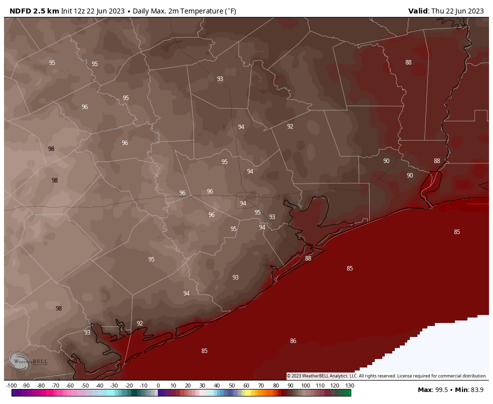
Conditions are marginally supportive of this, but the convective models don’t appear too excited about the potential for storms this evening. But they weren’t yesterday, either, with similar conditions in place. So what happens? I think we’ll see another storm system dropping out of the north this afternoon, but it probably will be weaker and make less of an impact than the one on Wednesday. Otherwise, expect low temperatures generally in the upper 70s.
Friday
High pressure begins to asset itself by Friday once again, so we’re going to see sunnier skies and highs in the mid- to upper-90s. After a lingering chance of showers early on Friday morning, the rain should be done. I’d peg overall chances at about 10 percent.
Saturday
Skies will be sunny again for the start of the weekend. Temperatures will not be super hot, but still in the upper 90s.
Sunday
The second half of the weekend does look super hot, with much of the region hitting 100 degrees. We may start to see excessive heat warnings again by this point.
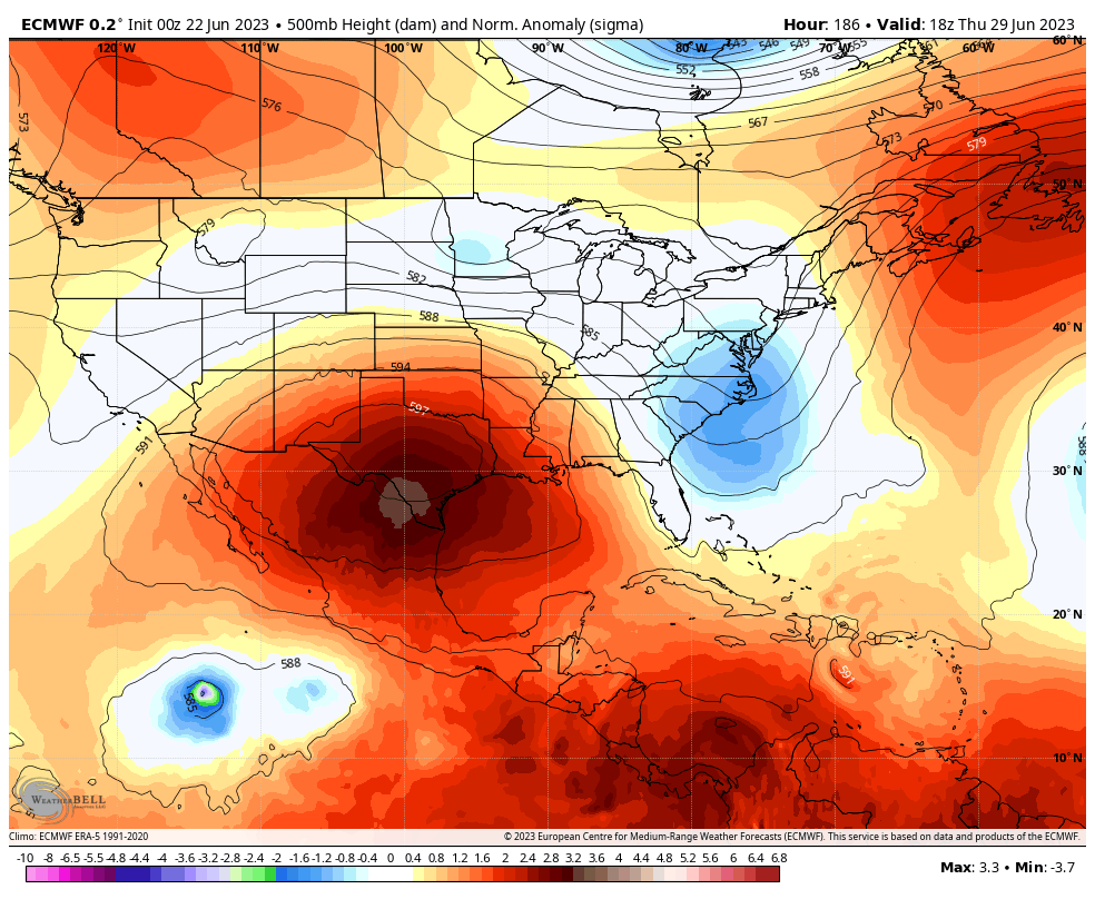
Next week
The bad news is that most all of next week looks really hot, with highs staying up around 100 degrees. The state is simply going to bake as a really stout high pressure system establishes itself over Texas. Rain chances will be near zero. There remain some hints in the models that this pattern will finally start to break next weekend as the high retreats west, but as we’re talking about a forecast about 10 days from now my confidence is still somewhat low. But I’m hopeful.


Sadly, while we saw a lot of lightning, we didn’t get a drop in my area of Katy (Westgreen/I10). Bummer. Maybe we will get lucky today!
Got much needed ~1” rain yesterday night here in Greenspoint/IAH area. Everything is looking lush again.
I agree with Katy comment. We did get .1” but kept power. The radar just snaked and morphed all around a bullseye over us Kingwood/69. The storms were all around us…quite the noise and light show but sure wish some of that rain fell here. We are parched also.
What a lightning storm! Intense for sure.
Is this high pressure system a firewall for Bret should it make it into the Gulf? So, no need to watch it here?
1/2″ rain near Westchase
Well. At least it’ll deflect any tropical stuff for now 🥴
Great graphics! They are so helpful in understanding the bigger picture. Tysm! 🌻
We’re still without power and water here in the bottom of the Woodlands. I’m on the fourth floor at an apartment complex at Kirkendall and last time I saw Winds like that was Ike. They had to be gusting up into the 70 to 80 mile Power Ranger. If not more. It was pretty bad.
I waited for the storms to pass before heading home, since I had to drive south. I was treated to quite the show of nature’s fireworks on the drive home. The lightning branching in the clouds is always a beautiful sight. Also a bit of rain for the yard.
I will gladly pass on anymore storms right now… Once my power comes back on I would like to enjoy it for a while 🙂
The winds were pretty crazy and it rained a bit. Also a lot of lightning.
Still without power in far north Houston/1960 area. Sigh.
SciGuy didn’t talk about it but I think a lot of potential energy gets built up when the sky is capped by hot air. Hot moist air can’t rise so you get the pressure cooker effect. Any disturbance like high pressure moving off allows it to blow. That’s what we saw. This is just a rough place to live climate wise. When was the last time you saw a tall alto cumulus cloud around here. Another feature of living close to an ever present high pressure dome over the high Mexican plateau
Another incentive to start my retirement planning travel. Should I do Tennessee or North Carolina first?
I’m curious: the wind speed record for IAH was broken (and reset) last night. What is the wind speed record for Hobby Airport?