I will not lie. (We never do, and that’s a promise you can bank on). When the National Hurricane Center issued its updated track forecast at 10 am CT this morning I had my doubts. Forecasters there seemed too conservative in not moving the track of Laura closer to Houston, as that is where a lot of the model data indicated it would go. However, in going over all of the just released data from 12z models, their track forecast (shown below) now looks pretty good. So, kudos to the pros in Miami.
What does the 12z data show? Several models have made slight adjustments eastward today, but the most significant movement has come from the UKMET model, produced by the United Kingdom. This is not the world’s best global forecast model, but it is competitive, and something we often look at. In the case of Laura, it has had some of the best performance to date since tracking began a few days. This meant we have weighted it a little bit higher for this storm.
One of the things that has concerned us is that the UKMET, although an outlier, had been frequently bringing Laura to the central or upper Texas coast. This would have placed Houston, Galveston, and the upper Texas coast on the powerful right side of the storm. However, in a just released run of the model, the storm’s landfall location has made a sizable jump east, from near Corpus Christi to the Texas-Louisiana border:
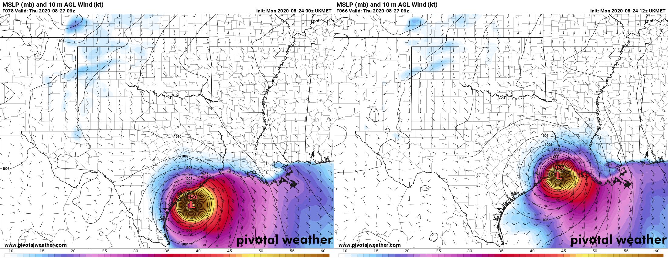
This brings the UKMET more in line with other global models in predicting a landfall near the Texas-Louisiana border, or slightly east of there. This gives us more confidence in a solution that brings Laura onshore just far enough east of Houston to keep the worst of its winds, waves, and rains away from the area. But this does not mean the track forecast is locked down—we still have a fair amount of uncertainty there. There are some very fine details in the positioning of several features in the upper atmosphere, and these could easily move a bit in the next day or so. That would be enough to nudge the forecast back toward Houston. So please, do not let your guard down and keep making preparations. But maybe, breathe slightly easier if you live in Houston. If you live in Beaumont or points east, the threat remains very high.
One thing I think we can answer is when we should have clarity on what Laura is really going to do. I am reasonably confident that the track will be dialed in by this time tomorrow, after Laura has come across the western edge of Cuba and emerged into the Gulf of Mexico. By this time it should be forming a more well defined center of circulation, and the models will have ingested better initial conditions. So our long, uncertain wait for some answers should finally come to an end within 12 to 24 hours. As ever, thank you for your patience.
To update the percentages I’ve been using for various scenarios, this is what I would now go with:
Scenario One: Near or direct impact on Houston by a powerful hurricane. (30 percent)
Scenario Two: Powerful hurricane near or east of Texas-Louisiana border (70 percent)
Scenario Three: Weaker storm, central or southeastern Louisiana (~0 percent)
I will be conducting a Facebook Live video at 2pm CT that you can find on our page there. Matt will provide our next update no later than 9pm CT tonight.

Thank you Eric and Matt. Super helpful. Will continue to prepare for what may come. Have fam in Beaumont I’ll be checking up on.
F-f-f-feeling better b-b-b-butt still n-n-n-nervous.
Prayers out to my co-workers in the Golden Triangle.
What does this mean for cities like Baytown?
I always ask this, Baytown is constantly left out
In a track that makes landfall near the TX/LA border or western LA, Baytown could likely expect somewhat worse conditions than Houston, with the potential for higher rainfall than Houston Metro, as well as somewhat gustier winds (although to the point where it would be inconsequential for a sensible weather standpoint as you’d likely be looking at nothing worse than low end tropical storm gusts at times). The primary determinant factor would be how smaller features within the storm set-up, how large the storm’s wind radius is upon landfall, etc. Being ~30 miles closer to the center, Baytown would have a higher probability of seeing squalls or outer bands of the storm than metro Houston, which would be the driving factor behind somewhat gustier winds and a potential for higher rainfall totals.
I know you hear it a lot, but many many of us are very grateful for your work.
One of the high altitude NOAA Gulf Stream planes flew Laura’s surrounding area this morning and will be making more flights today. I’m hoping this data will help a great deal in the subsequent global model runs to be initiated today.
Hello Eric,
Is there a public website you can go to that shows you the same spaghetti models you are using. I use myfoxhurricane put the models are all scrunched todether?
Thanks
Try https://www.cyclocane.com/spaghetti-models/ I like this one a lot.
This one has quite a few:
https://www.tropicaltidbits.com/storminfo/#13L
Correction to this comment.. I should read
I use myfoxhurricane But the models are all scrunched tog
ether?
http://trackthetropics.com/
Thanks for the info
Believe it or not, there is always:
https://spaghettimodels.com/
Yup, we can take a deep breath but we still have to wait until tomorrow’s update (per Eric’s words) to really breath a sigh of relief.
But, I still consider this a warning shot across our bow by Mother Nature. And, this season still has a lot of time still left in it. “Be prepared” is not just a slogan for the Boy Scouts.
What kind of storm surge could be felt in the Beaumont and Port Arthur area?
Thank you for all you do and keeping it simple and factual for the laymen our here. God bless
Yet another hit for the Golden Triangle. Not sure how much more our area can take.
Prayers for all my friends in family in Texas!!Stay safe and be prepared!It mother nature never know what shes gonna do!!!
Thank you for giving the percentages of how you think the impacts will play out..I appreciate your frequent updates, they certainly help me with my decisions..THANK YOU! I am also humbled and grateful for the many Air Force teams flying thru and around Laura while also simultaneously making flights thru the areas that are hundreds of miles away from Laura, to assess air currents..
Thank you for taking care of me & my family. Your honesty & expertise are very much valued.
Thank you! In your update tomorrow I hope to also hear:
How long will the impact last in Houston?
What days would we be able to
– make it in to work if desperate
– do things for fun
Wonder how Marco’s interaction with Laura will be… Thursday night will be interesting
You guys are awesome
Thanks so much! What would we do without you!!! I would currently still be in blind panic mode! Appreciate all you do!
Latest models getting more aligned. Looks as if we’re in the clear. Hope Beaumont and points east fare okay.
Given Scenario 2, are there any estimates of precipitation range we would see in the Houston area?
Precip estimates for Houston from NOAA have gone up a notch to the 2-4 range in their 2 pm model. I live in Meyerland, so I watch that forecast.
I used to live in Meyerland (got lucky and never flooded), so I understand your worries.
Very good information, thanks so much for doing this. I have a question, though: can you please clarify what you mean by “competitive” in referring to the UKMET model?
Oh I am happy for this update! My dear Fulgencio will surely be able to finally eat some dinner tonight and hopefully sleep for a few hours. Thank you Eric and blessings to everyone!
Where does your funding come from? Are you on Patreon? I would be glad to contribute. We live in Galveston and rely on y’all heavily year round but especially during times of high alert.
I think reliant funds it now but I’d sure like to send them a thank you cookie or pizza delivery if they had an email address I could send a gift certificate to.
Thanks Eric! If scenario 2 happens, what’s your best guess on storm surge water levels for Galveston.
Thank you for always keeping us posted, so grateful for this unbiased info!
Ok so I live in Cove/Mont Belvieu should I evacuate or not lol that’s all I need to know. I lost everything to Harvey so I am a bit on edge right now.
No one seems to mention this when they are thanking you but i hope you realize how helpful telling us when you will update is for some of us. I don’t handle any of this well but knowing when i can check back does help control the bad thoughts.
Why is the NHC discounting the Euro model so much? It has been a better performing model. I am still worried that the Euro model may actually be correct.
What is the difference between ECMWF and ECMWF ensembles? Unfortunately I don’t think we can see anything but the 00z and 12z for free, so I am just seeing the same track that NHC is predicting. I do believe in their expertise, and I do know lots of amateurs pointing out the most alarming predictions.
I was wondering if a strong Laura would take a more northerly track. Tropical cyclones naturally head due north, but get steered by other weather patterns. However, I heard that strong cyclones are less deterred by these patterns.
In a previous post a commenter noted that the Euro has been less accurate this year.
I will note that Eric and Matt have been good about not letting biases drive them and have incorporated their own weighting of the Euro into their analysis. Heck, their acknowledgement here of the UK and it’s recent performance reinforces to me that they will look deeper than I would.