Good morning. We’re continuing to track the severe threat posed by Tropical Storm Laura, and the majority of this post will be devoted to that. However, before getting into hurricanes, just a word about our weather for Monday and Tuesday. We expect partly to mostly sunny skies, with highs generally in the mid-90s. Both days will see a chance of scattered showers, especially along the coast, but we don’t expect anything too organized. Weather beyond this will depend upon the movement of Laura.
Tropical Storm Marco
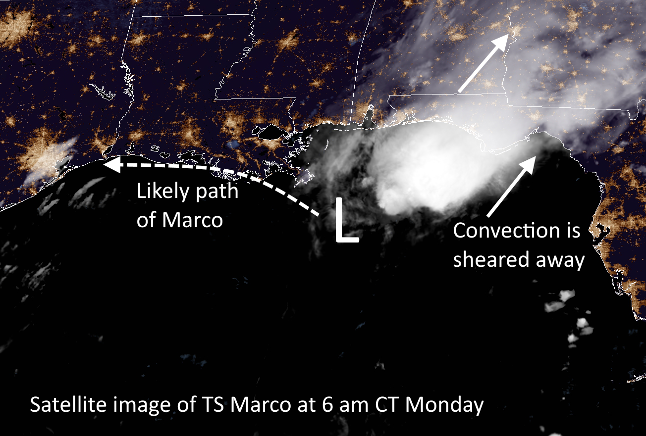
Marco is weakening this morning (50 mph) as it encounters wind shear over the northern Gulf of Mexico. It is expected to approach the southern coast of Louisiana tonight, and then slowly begin to track westward toward Texas. As its main convective activity will be sheared away, it should not bring any noticeable weather changes to the greater Houston region. However, Marco’s movement may play into Laura’s final landfall location as that storm nears the Gulf coast by mid-week.
Tropical Storm Laura
Here’s the deal with Laura. At this time there is a somewhat improving model consensus for where the storm will make landfall late Wednesday night or early Thursday, likely between Galveston Island and the south-central Louisiana coast. The National Hurricane Center has the storm coming into the coast near the Texas-Louisiana border, but we do not have nearly enough precision to rule out small-to-moderate changes in the track. And for the Houston region, any small shifts in the track westward will change our local forecast dramatically.
Put succinctly: Along the current track forecast Houston would see only modest effects in terms of wind, rain, and surge from a Laura landfall in southwestern Louisiana. However, a subtle shift 50 miles or more to the west would begin to bring serious effects into Houston. A shift of 100 to 150 miles would bring a potentially catastrophic hurricane into the region. This is entirely within the realm of possibility, and therefore the Houston-Galveston metro area needs to prepare now for a land-falling hurricane—possibly a major one. (This goes double for the Beaumont-Port Arthur area).
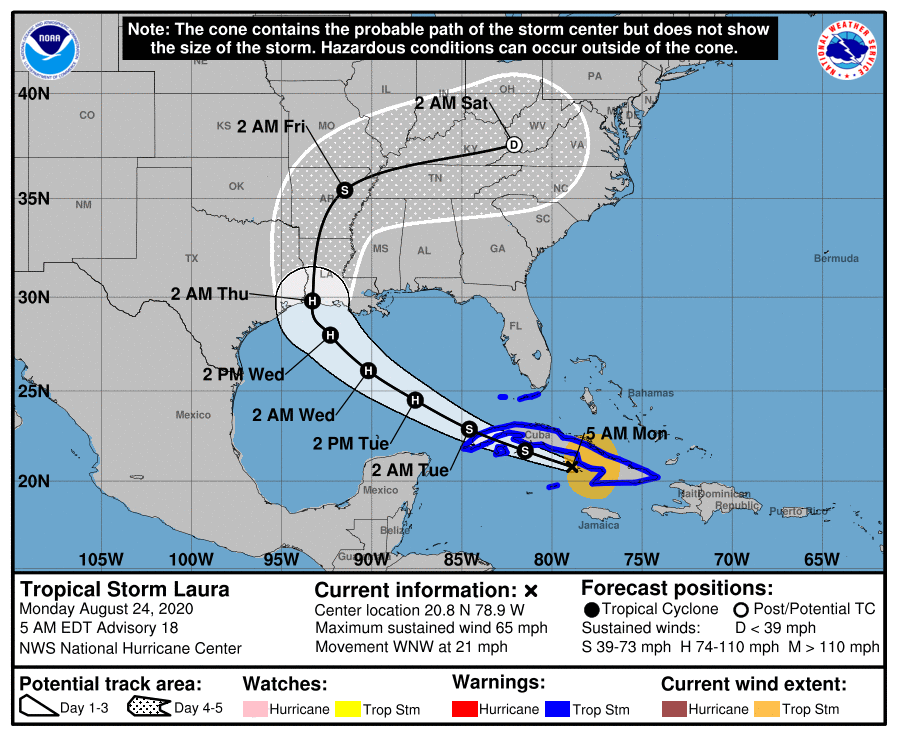
The dominant steering factor for the storm will be strength of a ridge of high pressure building over the southeastern United States, which will be influenced by a weakening Marco and a trough over Texas. It would only take a small change in these large scale features to change the point at which Laura makes a northward turn, which is why we’re unable to pin down the storm’s ultimate movement. In terms of intensity, Laura has remained near the southern coast of Cuba overnight, staying just offshore. This has allowed the system to maintain its status as a strong, 65-mph tropical storm. It still has the potential to blow up into a Category 2, 3, or even 4 hurricane over the open Gulf of Mexico.
Assuming a land-falling Laura near the border of Texas and Louisiana, the eastern half of the metro area has a decent chance of seeing tropical storm-force winds, likely arriving Wednesday afternoon or evening. Storm surge and tides will be entirely dependent upon track and intensity, but along the current forecast track probably would only be a few feet higher than normal. Overall precipitation would likely be on the order of 1-2 inches of rain, mostly east of Interstate 45. Again, I cannot state how dramatically these effects could change with a change in Laura’s track.
Last night I posed three different scenarios for Laura, and I wanted to update those very rough percentages in light of new data overnight.
Scenario One: Near or Direct impact on Houston by a powerful hurricane. (40 percent)
Scenario Two: Powerful hurricane within 50 miles of Texas-Louisiana border (55 percent)
Scenario Three: Weaker storm, central or southeastern Louisiana (5 percent)
Our next update will be posted no later than 2:30pm CT, and quite possibly sooner.

Thank you!
Oof
Watching with cautious optimism
Does weakening Marco and building pressure cause Laura to move more westward or more northward?
Thank you Eric!
So scenario 1 went from 30% to 40% chance correct?
Thanks Eric and Matt for the “no hype” reporting! We are so blessed to have you guys tracking the Gulf Coast weather for us!
So, for Beaumont/Pt Arthur, the most serious affects have to do with wind damage, correct? Rainfall amounts?
Just be a bit cautious, prepare for the worst, and hope for the best.
That’s not exactly good news for a large portion of us.
If you have to decide between riding out storm in college station or Austin by 1130 am today, is college station sufficiently far away?
Friends who live in Baytown have made reservations in Brenham for Wed thru Friday…
Probably, but austin is more fun 🙂
Sho is! 😎
College Station will be lucky if they even see a rain shower…….
Either one is going to be fine. I was in Bryan/College Station for Rita in August or September of 2005. Everyone was in a panic, because Katrina had just hit New Orleans just a few weeks earlier in the season…Houston had a major evacuation, which resulted in traffic being stuck for days, and deaths from heat stroke and dehydration to those stuck in cars on the freeway. Meanwhile, College Station was battening down the hatches. Rita was a very strong storm, but hit east, near Port Arthur, if I recall. College Station got a few sprinkles.
I was in College Station at that time as well Jason. I worked for the radio group that owned Candy 95 under the station engineer. We were preparing to sleep at the station to do everything we could to keep them on the air. I believe they were predicting it to still be a Category 1 when it got into the area. They’d also moved the Aggie football game up to Wednesday and asked people not to come.That was a crazy time.
Ike was crazier–we played Texas State early and it rained. HARD. For most of the game.
Also, BCS was relatively unscathed by Harvey–should be plenty far away for Laura.
Thanks Eric. Cuban radar indicates the center of circulation is further south than most of the models forecast. So does a starting point further south meaning less interaction with land and a possible stronger storm with a trajectory further west?
I am not a meteorologist but it seems the next update from the NHC will move the cone of death a little further west and I would expect the media to ratchet up the fear in their quest for clicks and views.
I live between Houston and Beaumont on Highway 90. If Laura makes landfall near Beaumont would the wind be coming from east to west?
Picture the spin of a hurricane. Picture where you live. Picture where the hurricane comes ashore. That’s all you need to visualize (notice I didn’t say “picture” :p) the wind direction.
Greetings from the Beaumont/Port Arthur area! Thanks you for the information and keeping our area in the loop! We are getting prepared over here in SETX! 👍😳
What would be the difference in affect to Houston between scenario 1 and 2?
As Eric noted, a shift of 50 miles west by Laura will make a big difference for the Houston metro area.
Since we cannot control the storm’s actions, prudent people prepare preemptively (yes, the alliteration was deliberate). At the worst, you did a drill and can fine-tune this process.
So the idea of Marco tearing apart sooner than later and allowing Luara to track more in an easterly direction?
How likely do you think the Cat 3/4 is, especially if it drifts far enough towards western Houston – Memorial, Katy, Sugar Land? Tropical Tidbits is showing most models leaning towards 1/2.
Not that I’d be sneezing at that, but I’m curious how much I need to plan to batten down the hatches (or make a strategic withdrawal to San Antonio/Austin/somewhere inland).
I’d keep firmly in mind the disaster that befell folks fleeing the hurricane in 2005. Hundreds (maybe thousands) of cars overheated and broken down, interminable waits to travel a single mile, heat stroke deaths, the fiery bus mishap that killed many seniors, misery suffered by hundreds of thousands. PANIC is never a good thing. But the %^$%^#% media FEEDS on it, ratings everything to them. They care not at all that their false “reporting” quite literally kills people. If you live in Houston proper, not in a flood prone area you are FAR better off staying put. Winds are extremely unlikely to flatten your home. A supply of food, potable water, maintenance medications, and a full tank of gasoline should see you (and family) through. Bring in lawn furniture, tape and or board up windows. prepare to live with your critters inside for a while and ride it out. I have lived on the Gulf Coast for over 70 years, and have had a house collapse on me during a hurricane. Celia in 1970. So I speak with some experience, not relying on printed bs, but my observations over many storms covering several decades. Be prepared Neil, but don’t let generated hysteria lead you down a bad path.
RUN from the water, HIDE from the wind.
If you are in an area that is most likely to have wind impacts, you are not in a flood risk area, and your dwelling is structurally stable, consider hunkering down.
Regardless of where the worst of the storm strikes, if you haven’t trimmed branches or bushes away from the side of your house lately, this is a good time to do so. If we miss the worst of the storm, hey, you have a tidy yard.
This is the year I’ve been questioning my career as a buyer for a large grocery store. 🙁
2020 is the year everybody is questioning everything…
Hey Eric, Matt. It seems Marco is getting gutted by shear. As that shear-enforced warm moist outflow is aggressivley shoved off to the northeast, slamming into the H in AL/GA, wouldn’t that stronger deeper H in turn push Laura more in a SW direction by the time she shows up post Cuba?
The winds generated by a hurricane, as with Laura, clock around as it passes by. If it passes to the east of Houston, will the hurricane winds clock from NE to NW as it approaches and passes?
Here’s why I ask. As I prepare my yard, I want to park/stow/secure as much stuff as possible, away from the the house. Knowing what the direction of the winds might be, clocking as the hurricane passes by, makes it easier/safer for me to plan the best spots to safely park/stow/secure things to minimize damage.
A couple decades ago, I rode out a hurricane in the Bahamas on my sailboat. I think the winds as it passed to the east of us, clocked from NE to NW. So, I anchored my boat in an anchorage with maximum protection from those directions. It worked great!
Now, I’m older, living on land, and my memory has faded. So, I’m hoping for some guidance here. Thanks.
Jim B
Why did you increase probability of Houston hit from 30% to 40%? I don’t see that in many models.
Your reports are the first and last emails I read daily! I am confused about one thing, though. I thought that Laura is supposed to take a more easterly course if Marco weakens, thus sparing Houston from the brunt of the storm. Is that still the prevailing wisdom?
Eric and Matt have NO CLUE what will happen other than a lot of wind, rain, wind, and surge. Where/what/how bad it gets is to be determined. If you live in a low area, prepare accordingly.
People far enough inland (you should have a clue who you are!) should prepare to stay and hunker down. Please be responsible adults and not clog the streets for those of us who live in the coastal areas who MUST leave due to the impending danger from a storm surge. That is why areas evacuate. Not because of power outages, or wind. But because of storm water that won’t simply “drain away”.
We all have to help each other. Be safe. Be smart. Be kind.
I’m curious why Laura is taking such a different track then Marco. Seems the steering currents should be similar. Is Marco modifying the atmosphere that much?