In brief: Well, it’s over. In today’s post we discuss last week’s extraordinary precipitation event that finally ended Sunday, and some lessons learned. Houston faces calmer weather this week, with two frontal boundaries coming later this week and over the weekend to bring some drier and slightly cooler air into the region. Unfortunately it does appear as we’ll see some decent rain chances on Mother’s Day.
A week of rains
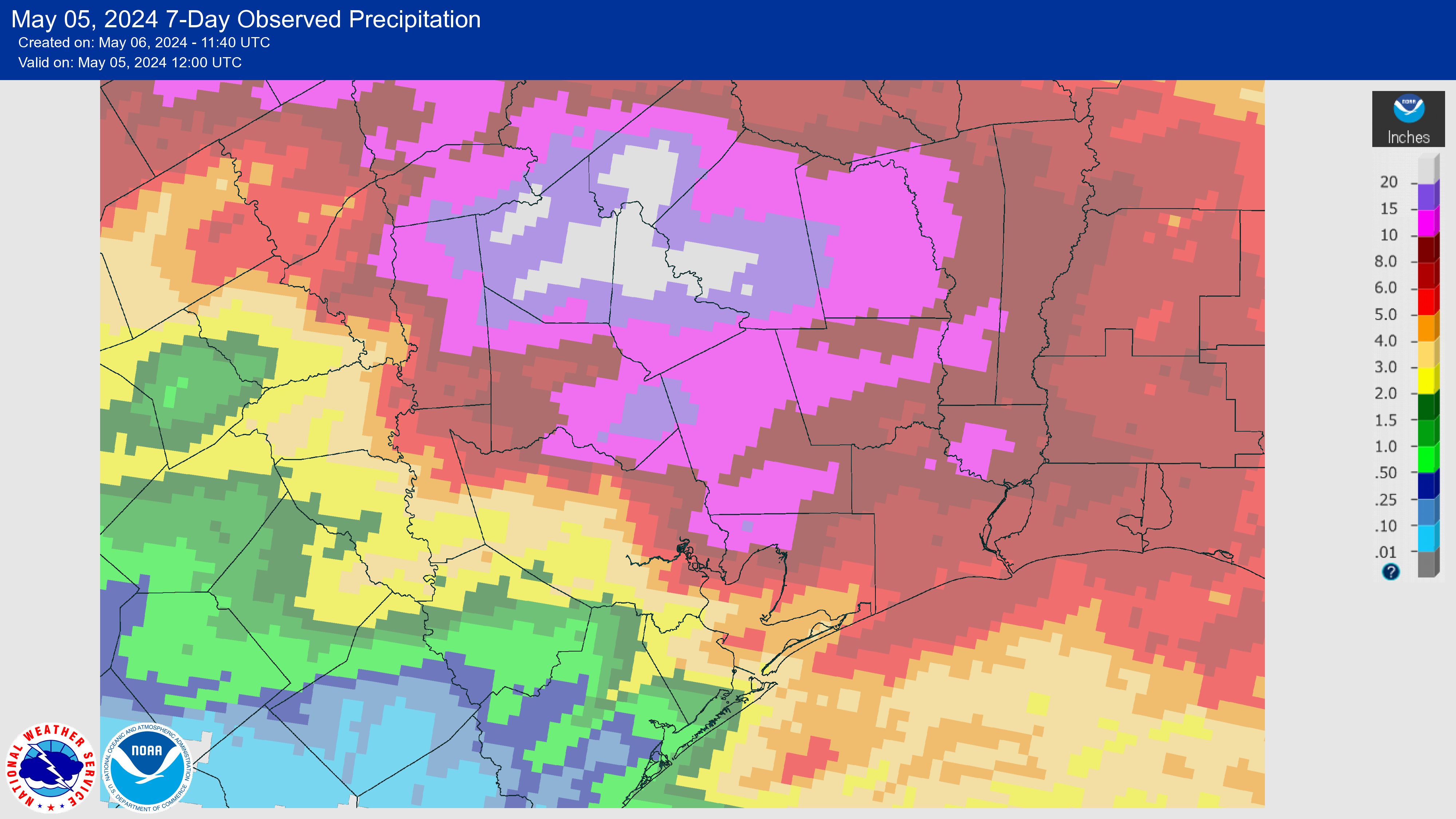
The map above shows rainfall totals over the last week, and for locations north of Interstate 10 they’re pretty incredible. Some locations in Walker and San Jacinto counties recorded in excess of 25 inches of rainfall, and closer to Houston eastern Montgomery County picked up 15 inches of rainfall. The southern half of the region, by contrast, saw significantly less rainfall.
Matt and I have taken away a couple of lessons from this. First of all, it’s a reminder of the unpredictability of these kinds of rain events, where you have slow-moving boundaries that are able to tap into ample moisture from the Gulf of Mexico. These springtime rains are among the hardest to predict. To wit, as late as last Tuesday we were calling for 0.25 to 2 inches of rainfall for the week, and saying, “These are likely to be garden-variety showers rather than anything too intense or organized.” Obviously that was a huge, humbling miss. We weren’t alone in that miss, and no one was predicting what ultimately happened. But it’s safe to say this is a learning opportunity for us.
We also are going to continue to tweak our flood scale. For much of the Houston metro area last week’s rains provided some on-and-off street flooding, but nothing more. Our Stage 1 and Stage 2 warnings largely reflected the urban flooding risks. But for neighborhoods along and near the San Jacinto River, these were catastrophic floods, closer to Stage 4. We need to address this discrepancy in a future version of our flood scale. The good news is that we’re working with a local university to include public feedback into this upgrade, and you’ll have a chance to participate. Look for that opportunity later this week.
In summary, this was a badly forecast rain event. I am glad it is over. It was, frankly, a nightmare to forecast. Matt and I lost a lot of sleep. We will learn from it and do better in the future.
Monday
We are transitioning to a pattern with higher pressure this week, and that will bring an end to unsettled weather for awhile. There will still be perhaps a 10 to 20 percent chance of rain today, but any showers that develop will be scattered to isolated, and fairly short lived. Otherwise expect partly to mostly cloudy skies, with highs in the mid-80s. Winds will blow from the southeast at about 10 mph, with gusts up to 20 mph. Lows tonight will be muggy, with temperatures dropping only into the mid-70s.
Tuesday, Wednesday, and Thursday
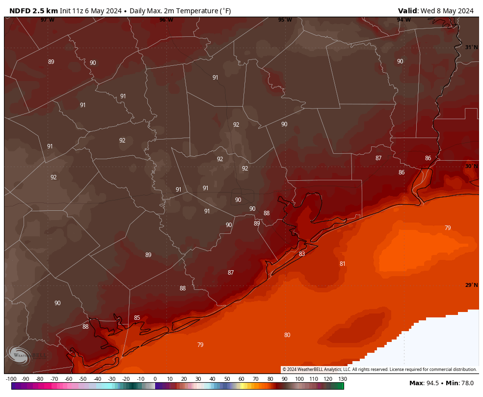
These likely will be the warmest days of 2024 so far. Expect highs to reach about 90 degrees each day in Houston, with slightly warmer conditions to the west of the city and slightly cooler daytime highs near the coast. Skies will be partly sunny with a decent southerly breeze. Nights will be warm, in the 70s. It’s been awhile since we’ve experienced this kind of heat and humidity, so please give your body some time to acclimate.
Later on Thursday, or perhaps Thursday night, we could see the return of some rain chances as a front pushes into the Houston metro area. The timing of this is still a bit fuzzy, so it’s not clear whether we’ll see any cooling on Thursday. I tend to doubt it.
Friday
Highs on Friday should be cooler, in the mid-80s, with the influx of drier air. I think we’ll see partly to mostly sunny skies, with lows dropping into the 60s. This weather won’t be chilly by any means, but it does offer a nice reprieve from the heat and humidity earlier in the week.
Saturday and Sunday
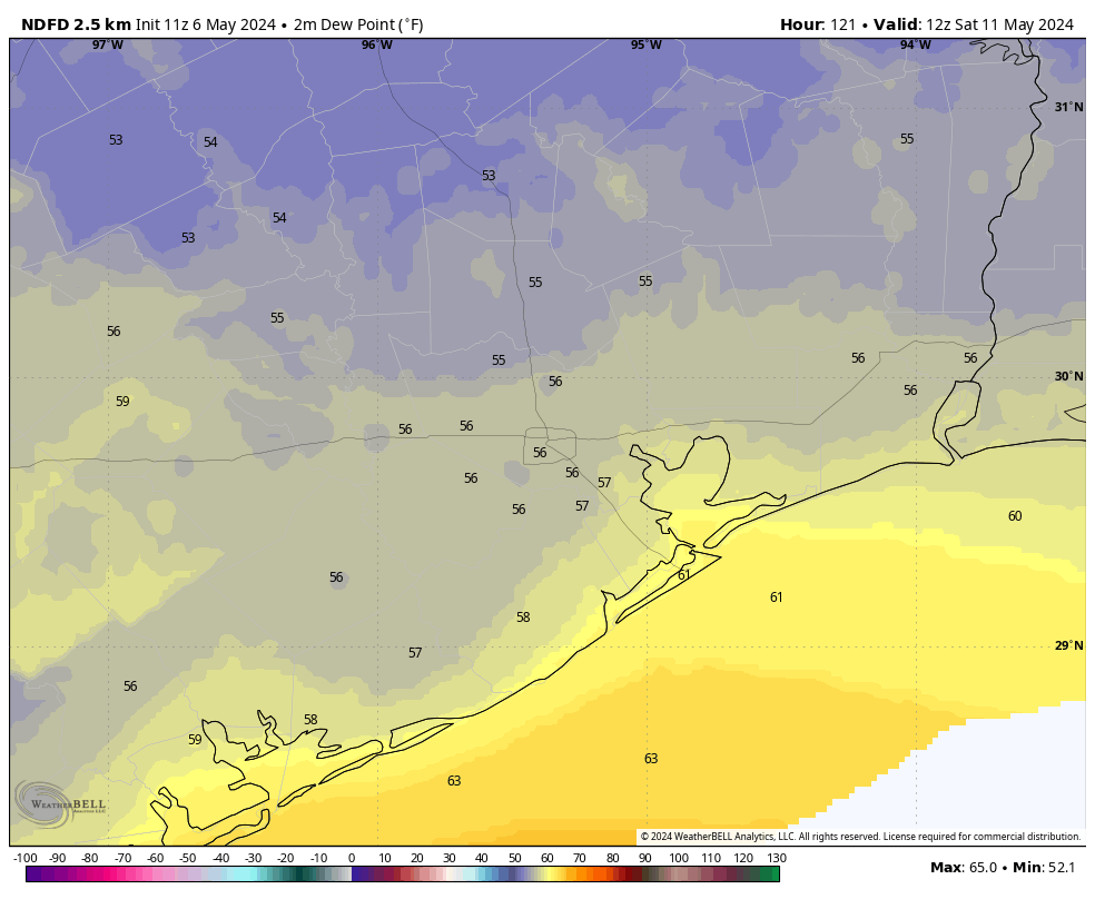
Saturday should see the driest air of the week, with dewpoints perhaps dropping into the 50s. I think we’ll see high temperatures in the low 80s for both days this weekend, with partly sunny skies. In terms of lows, we’re probably looking at the 60s, but I don’t feel super confident yet in overnight temperatures. Unfortunately for Mother’s Day, as a secondary front approaches, I think we’ll see an increase chance of rain showers—probably not anything too serious but enough to put a damper on things. If you have outdoor plans for next Sunday, please keep an eye on the forecast.
Next week
We may continue to see temperatures in the 80s for much of next week, with lows in the 60s to start the week before we return to the 70s. After some rain chances on Sunday and Monday, we should settle back down to partly sunny skies. In any case, two fronts in the middle of May are more than welcome in my book.

Your ability to self-reflect and admit the unpredictability of weather in this region is the reason I continue to follow your posts. Thanks for providing the content you do and for being real.
You guys are awesome!! I love your reporting now matter the level of accuracy
Front in mid-May? I think we can call it “last front”.
Hunker down for another brutal Houston summer.
Dew points in the 50’s in mid-May are more than welcomed!
Thank you for your honesty about the forecast last week! I think it’s so easy to get frustrated when the forecast is off, but there’s so much most of us don’t understand; so when you’re transparent about it, we can all learn from the experience.
Matt & Eric, you were there for us when it mattered the most – there is no one like you.
💗 tysm
Add me to the chorus of appreciating SCW and all of its team members. Y’all do your best with no hype but Mother Nature is fickle so we can’t hold her antics against you.
Looking forward to the drier air at the end of the week, even if it is a short burst.
I take exception to your “humbling miss”. statement. Yes you did not get it all, but I live in an area near Jersey Village, where we got a welcome 1 inch of rain and some stormy weather. That matched your forecast. Keep up the good work.
Thanks, Eric and Matt for the great work last week. I appreciate you taking your “mea culpa” today but in your defense, spring rains in Texas are incredibly difficult to forecast. I spent time at a state water agency early in my career. The most difficult months were April to June. A “little system” could get stuck, train and dump feet of rain with little to no forecast and the flooding was on (I remember one especially virulent system in the ‘90s over the Hill Country in June. Austin old timers can also tell you where they were in the Memorial Day flood of the ‘80s)
YAAAY! I am so glad there is still a smidge of spring on the horizon, I am still not ready for June.
Don’t beat yourselves up. You guys don’t design the models, you just interpret them. I don’t think any of us expect you to pull a meteorological rabbit out of your hat and come up with something the models themselves had no clue was coming.
Yes weather forecasting is hard. Down here in Sienna, we maybe got an inch of rain in total between 4/29 and this morning. Where I used to live, Salt Lake City, it SNOWED several inches in the valley on 5/4. Forecasters were saying just rain in the valley and mountain snow. And as Blackhawks Fan said, get ready for a long hot summer.
SCW, here in southwest Houston your forecast was 100% correct. Our rain total was just a hair over 2″. All things considered, nationwide weather this past week was over the top with the tornado outbreak followed by the southeast Texas deluge, capped with an overperforming winter storm in northern California, the Pacific NW and the Intermountain West. Thanks for all that you do!
That was more humble pie than necessary. Just pick yourself up and get back to it.
Does anyone know what’s wrong with the weather readings from Hooks Airport (KDWH)? They have not pushed out any weather readings (temp, humidity, wind speed, etc.) since May 3.
You guys did your best! NO one should be asking for better. Appreciate the learn from it attitude but do NOT beat yourselves up from honest effort. You two are doing a SUPERB job and our entire community appreciates the effort!
Appreciate the transparency and am so grateful for you. I look forward to the nerdy deep dive on how the storm came to be what it was. I was explaining to friends who called to check on us that it just seemed to train and then sit on the same area north of the city for days. It’s terrifying that that can happen somewhat out of the blue depending on a literally unpredictable confluence of circumstances. Wishing everyone impacted the very best as they recover.
Unfortunately my backyard only picked up 0.30 inches out of this whole event. I don’t want the devestating floods that the Huntsville and Trinity area got, but we definitely could of used alot more than we got down here. There are already open cracks developing in my yard.
As others have said, thanks for the introspection.
But here’s where y’all really came through: as it became apparent this event was going to be significantly worse in certain areas, y’all were updating a couple of times a day to let us know [I’m thinking in particular of the “Well that accelerated quickly” subject line update] of the changing nature of the forecast as well as what the updated models were suggesting.
Tough week, but good work in the big picture of things.
I appreciate the fact when you feel the forecast was “off”, you offer an explanation as to what made it so. I mainly watch one local TV station and their chief metrologist never does this.
If it makes you feel better, the old school meteorologists who rely more on experience & intuition and less on computer models, get it wrong a lot more.
Rain totals……How can we be this far off? My new gauge sitting in the open I emptied 3 times over 3 days. Once 6 inches, once 5 inches and once 2 1/2 inches. I’m just south of the Woodlands. I also heard the golf commentators say the course had received over 12 inches in couple of days….they have weather guys there too. Then local news says totals like 4 , 4.9, 3 ? maybe for Spring. I know pockets, etc. but geez we are a long way apart. Different gauges or just location randomness? thanks….keep up the good work
National newscasts picked up the “Houston flood” story and people thought the entire city was inundated. My wife’s cousin in Arizona called to make sure we were okay. We assured her we were many miles from the areas that were flooding, which were mainly outside the city. I checked the website for the Harris County Flood Warning System several times over the weekend and flood gauges showed that easily 90 percent of the creeks and bayous in Harris County stayed within their banks. Having had water enter my own home during Tropical Storm Allison in 2001, I’m sympathetic to those who actually flooded. However, I wish people who write about news and weather would distinguish between whole-city events and those that affect people in smaller sections of the city — the northern and northeast suburbs in this case. People in much of the country got the impression from TV news that Houston was having another Harvey-like flood. That is incorrect. Not to downplay the disaster for many area residents, such as Kingwood, but the Astros didn’t cancel their game at Minute Maid Stadium. Music concerts went on as scheduled. People in most of the city went out to dinner and the theater. Judging from some of the comments above, it was a normal, semi-wet weekend for most Houstonians.
Matt and Eric,
Sometimes the bad guys turn out to be the good guys, so ‘May the Sith’ be with you.
Matt and Eric
As a Kingwood resident and also a homeowner on the Texas coast I truly appreciate your information. I am pretty much glued to SCW during H ( don’t like the word) season. The story or information that is not being covered is the misconception that rain in Kingwood actually causes this. While the amount of rain definitely contributes, everyone who studies this and other events like it know that the flooding here is caused by excessive release of water from Lake Conroe and poor management of Lake Houston levels to adequately deal with these releases. While I am thankful my home did not flood this time(but again far too many did) , many streets and roads were impassable in addition to the homes damaged. This is not a forecast issue or a rain issue. It unfortunately is a political one and the SJRA and City of Houston, including the mayor’s office and local congressional representatives, have not done what was promised and funded by bonds and taxes. It is a shame the amount of property taxes the residents of Kingwood and others pay to the city to be repeatedly flooded by an authority that is more concerned with the business of water rather than protecting property owners. I pray this latest event will open the eyes of local leaders and more work will be done to protect everyone along these river complexes. This is Houston more unpredictable rain and storms are coming.