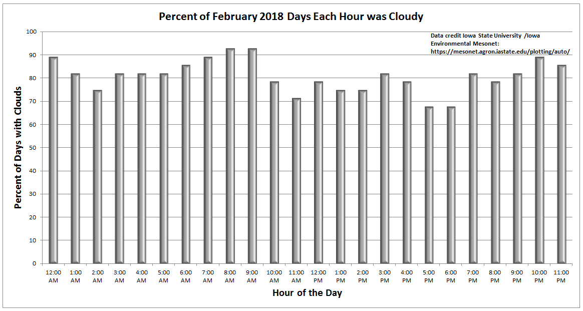
Thursday ended up being a beautiful day. It’s almost like we turned a page after February. With all the data from last month in, we can crunch some numbers now and tell you just how cloudy February ended up. Iowa State University’s Iowa Environmental Mesonet has a useful tool that takes every hourly observation and tells you what percentage had overcast conditions reported. Keep in mind that how hourly observations are taken has changed a bit over time, so there are likely inconsistencies from 1970s data to 2018 data. But since at least 1973, no February has been cloudier in Houston. Of all hourly observations last month, 81% had cloud cover reported.
The next closest February was 1989, when 65% of the month had cloud cover. What’s more interesting? February 2016 was the least cloudy February since at least 1973. So, of the last three Februaries, we’ve had both extremes recorded. Impressive.
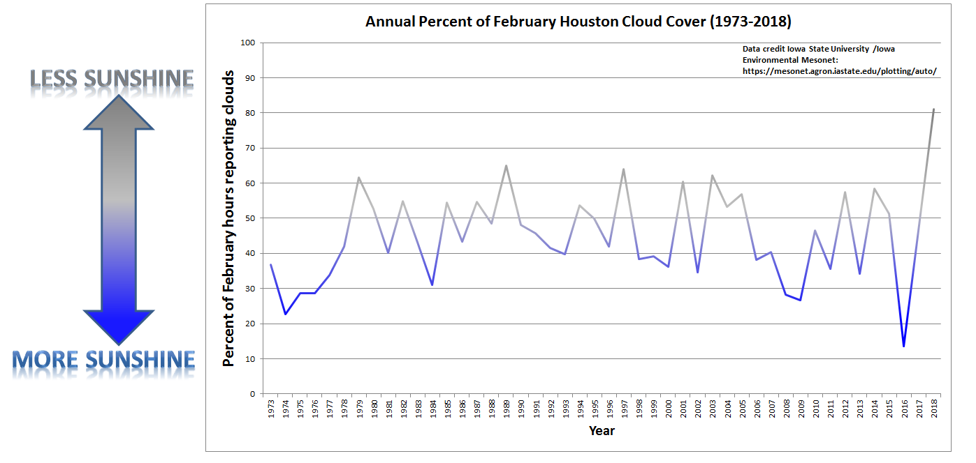
You can enlarge either image above by clicking on it. So, that was February. The responses I’ve seen from people have been impressively divided and partisan. Some of you absolutely loved that kind of February. Others were really struggling without sunshine. I fall about 80% of the way into the latter camp, but take what we can get before summer sets in, right?
Either way, we’ve turned the corner. Let’s run down the forecast.
Today & Saturday
We have the antithesis of February’s weather today. Expect ample sunshine and low humidity. We’ll generally top off in the lower or middle 70s this afternoon after a refreshing morning. “Perfect weather” is a very subjective definition, but I have to think today will come close to checking most of the boxes. Overnight lows tonight into Saturday morning could even be a couple degrees cooler than today. Expect some scattered 40s north and lower or middle 50s elsewhere (though milder at the beach).
Saturday looks fine for now. We’ll begin to notice clouds creeping in through the day as onshore flow kicks back in. If you live from about Sugar Land south and west, I wouldn’t be shocked to see a few showers or sprinkles pop up in the afternoon tomorrow. But I don’t think it would be anything too problematic. High temperatures Saturday will reach for the lower 70s once again. Most Saturday outdoor plans should be fine.

Sunday
While we’ll see the threat for scattered showers pick up on Sunday, we don’t think the day is a washout. It will be less ideal than Saturday, but none of the models are currently projecting more than a couple tenths of an inch of rain here and there. Have an umbrella at the ready, and hopefully you won’t need to use it. The best chance for Sunday showers will probably be north of I-10. Temperatures warm up, and we’ll go from near 60 in the morning to the mid-70s on Sunday afternoon.
Next Week
The forecast from Monday through Wednesday is both straightforward and very complicated. Contradictory? Yes, but there’s a good reason. A cold front is going to sweep through and bring a likely period of rain and thunderstorms to the area, followed by a cooldown late week. Simple, but whether that front arrives Monday afternoon or Tuesday evening is up for some debate.
For now, I would say a good chance for showers or scattered thunderstorms on Monday afternoon or evening, along with warm temperatures, generally in the mid-70s. We could make another run at 80° if we see some sunshine, but that is a low probability right now. Monday night into Tuesday afternoon, I’d say we’re likely to see a period of thunderstorms before things clear out Tuesday afternoon and evening. Cooler, drier air will follow, and we may be gearing up for a couple nights in the 40s in the area, especially on Thursday and Friday mornings. It will definitely feel a bit chilly. We’ll iron out specifics for you on Monday morning. In the meantime, enjoy a nice Friday and Saturday!
Absolutely hated the cloudy days on end. Ready for Spring and our Astros.
Matt…thanks for taking the time to gather and share the “cloudy” data…very interesting…sure seems national weather is making its share of headlines these days…sorta bothersome…
Great weather reporting Matt and Eric as always. Thanks you both so much. Had just one question about the ISU Mesonet – is that a tool (perhaps looking at Satellite data?) applied to Houston that gave you the data or ?? Surely it’s not measuring cloudiness in Iowa instead.
Nope. That tool will let you look at any station that reports hourly observations (in the case of the charts shown here, IAH Airport) around the country. How they compiled the historical data? I’m not quite sure, but I trust that it was done correctly.
My prescription sunglasses are sitting somewhere at the bottom of the Gulf of Mexico so I didn’t hate the cloudy days. Need to get new ones soon though. Texas Summer sun is quickly coming.
OK, it’s Saturday afternoon…. the sun is…. where?
Above the clouds.
Thanks so much for sharing!