An active weather pattern over Texas will slowly increase our shower chances each day this weekend. Generally, the deeper into the holiday weekend you go, the better the rain chances will become. Today and tomorrow probably won’t be too bad. Sunday could see heavier rain west of Houston and Monday could see more widespread coverage of thunderstorms in the Houston area. Specifics beyond “showers and storms are possible” will be hard to come by more than 12 to 18 hours in advance; such is the nature of weather patterns like this. Let’s walk through each day and tell you what we know at this time.
Today
Expect some clouds and some sun today, with sun probably becoming more dominant as we roll toward afternoon. There’s a little more moisture available today, so we will at least mention that a shower or storm is possible. As I am finishing writing this, it’s evident that some showers have popped up out toward Wharton County and up through Columbus, well west of Houston but somewhat sudden and unexpected this morning. We think most activity should be spotty (call it like 10 to 20 percent or so), and storms should be very much the exception, not the rule today but hopefully these morning showers are not a harbinger of a busted forecast to come. We will see!
It’ll be hot and humid with highs around 90° or so for the fifth day in a row.
Tonight
Another round of showers and storms in North Texas may just have enough “oomph” to hold together as it drops south and east late tonight. We could see a shower or a thunderstorm, mainly north of Houston after 3 AM or so. For most of us? Just mostly cloudy with a slight shower chance or some mist. Lows will be in the 70s.
Saturday
On Saturday, the best ingredients for thunderstorms remain mostly inland or to our west, which means Hill Country may be the favored area for more numerous showers. We’ll call it a spotty day once again for Houston with a few showers or storms possible, once more being the exception rather than the rule. Odds of storms may go up a bit as you go to the north and west of Houston.
Look for another hot day with highs likely staying in the upper-80s or low-90s under partly to mostly cloudy skies.
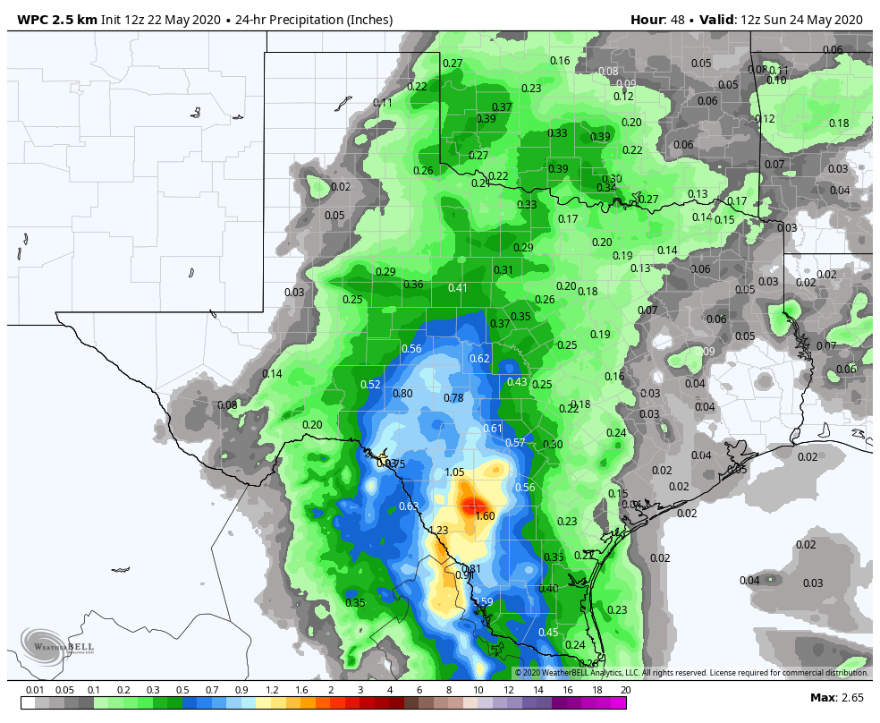
Sunday
So on Sunday, the best ingredients for storms drift a little closer to Houston. While we think the coverage of storms will still be highest to the west of Houston, there should be slightly better odds for much of the area to see storms. I would say storm chances jump up close to 50 percent on average for Sunday afternoon, higher west of I-45, lower east of I-45.
Sunday’s storms could also be better organized than what we see Saturday in Texas, so heavier rain is possible. We would say that areas west of Grand Parkway up through Conroe stand the best chance of heavier rains impinging on plans Sunday afternoon. But again, specific details are tough to pin down, so most of the area has at least a chance at some storms Sunday.
A muggy Sunday morning in the 70s will give way to highs only in the mid-80s, maybe upper-80s with clouds.

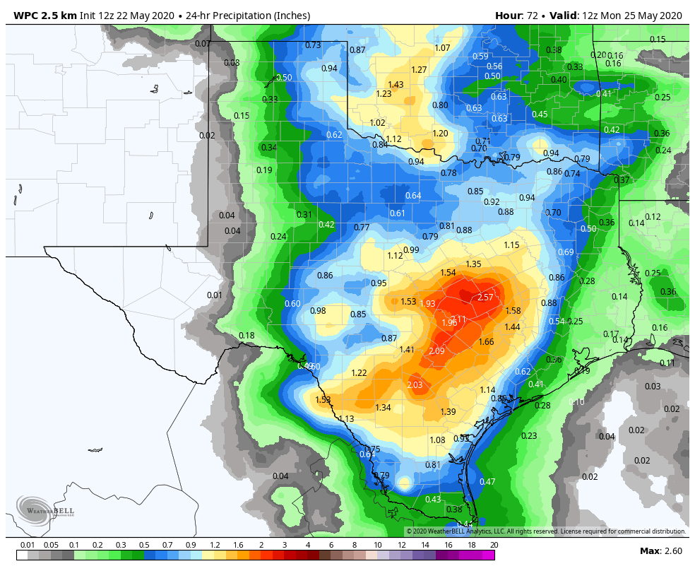
Memorial Day
We would probably plan on a slightly more dicey day Monday. Expect showers and thunderstorms to develop virtually anywhere in the Houston area Monday morning or afternoon. We could see locally heavy downpours with Monday’s activity. We don’t see anything particularly alarming right now (more on that below), but anytime you have storms like these in May, some street flooding can occur. Morning lows will be in the 70s and daytime highs probably top off in the low- to mid-80s.
Rest of next week
This far out, it’s impossible to say anything about details for next week, but Texas is likely to remain locked in this healthy, moisture-rich pattern with numerous daily shower and thunderstorm chances each day through at least Friday. We’ll have muggy nighttimes, but daytime temperatures will be held down due to clouds and showers each day with highs in the mid-80s at best most likely.
Flooding risks?
Obviously with a lot of rain in the forecast each day, we will inevitably get questions about flooding concerns. Right now that isn’t a top of mind concern for us because it’s impossible to say if any one location will get dumped on. But it’s a wet pattern in Texas in May. You always need to be aware that it could sneak up on you.
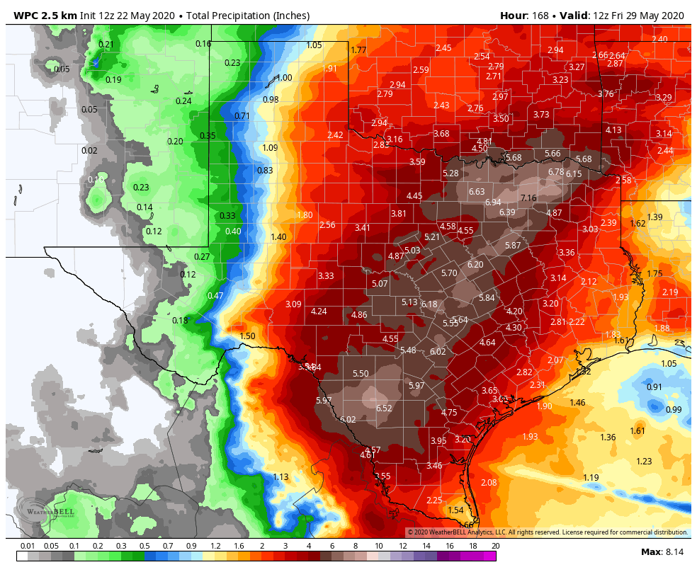
If you’re traveling to Hill Country or up to Dallas this holds for you as well. If you’ll be camping this weekend anywhere in Texas, especially adjacent to a river or creek or stream, please make sure you have a way to receive weather warnings and remain weather aware in case things do get a little out of control. Otherwise, check back in with us early next week to see if anything has changed.
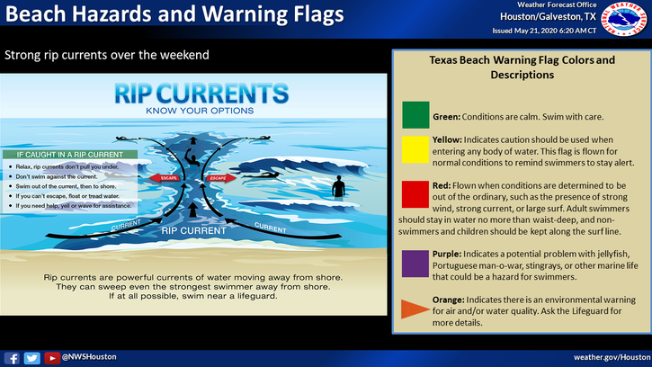
Rip currents & marine hazards
Persistent onshore flow is a good recipe for rip currents on the Gulf Coast. If you’ll be at the beach anywhere on the Texas coast for the holiday weekend, please be aware of the rip current risk this weekend and be smart when going in the water.
Also, if you’ll be out in small craft on Galveston Bay or elsewhere this weekend, please just be aware that onshore winds will be gusty at times, perhaps up to 20 or 25 mph.
I’m rooting for the Hill Country and some of West Texas to get a good dousing. They could use the rain to refill lakes and reservoirs.
As always, what a phenomenally well-done and detailed, clean, thoughtful forecast for the Houston area and Texas too. We’re lucky to have y’all!
What is it about Memorial Day weekend and potentially heavy rain in the Houston area?
I think it’s really the time of year. This is prime storm/flood season so it just so happens that Memorial Day and that peak intersect more often than we’d all like!
This website is pretty much a god send. I found y’all during Harvey and have used SCW exclusively to get the best forecast available. Thanks a lot guys!!! Please keep up the excellent work.
Quick Q- What is your go to weather app???
I usually tell people: If you have an iPhone, the native app is fine for everyday use…fails usually during big events, but honestly all weather apps do I think. Storm from The Weather Channel is good. RadarScope is the best if you want a high end radar, but it costs $10. WUnderground is also good, though it’s not as good as it used to be IMO.
Have you any input on the supposed June 1 TD development in the gulf? I would like y’alls opinion.
The atmosphere could be conducive to something, but it’s at least 10 days out, so I won’t get too cute with any details. A lot of questions right now about whether anything forms #1, and #2 whether steering currents would move something that forms to go east toward Florida or stick around the W Gulf for awhile…or just drift back into Mexico. I wouldn’t worry much about it right now, but it’s something we’re just casually watching right now without any specificity on any modeling.