POSTED AT 6:40 AM CT TUESDAY: Unfortunately we don’t have great news to report this morning. The overnight trends with Laura are not good and everyone in the greater Houston and Galveston metro area needs to be making final preparations for a potential hurricane landfall. After moving off Cuba overnight, the storm made a slight westward jog, and this has had the effect of nudging several model runs west. This is likely to bring the center of the storm closer to Houston, and this is not good.
Track forecast
It now seems highly likely that Laura will make landfall somewhere between Freeport and Southwestern Louisiana—with the most probable location between Galveston Bay and the Texas-Louisiana border on Wednesday night shortly before midnight, or early Thursday morning. This forecast is a worst-case scenario for the Beaumont area, and a mandatory evacuation order is in effect for Jefferson County. The situation is not much better for the Houston area. Please note: The official forecast track shown below will likely be adjusted westward, toward Houston, at 10am CT this morning.
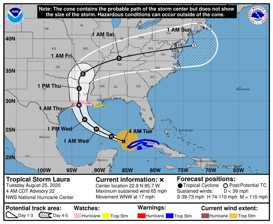
Now that Laura is over the open Gulf of Mexico and strengthening, confidence in the track should increase later today. Further changes will certainly be possible due to wobbles or other factors in the storm’s movement, however.
It is very important to really understand where this storm will go. Hurricanes have effects over a large area, but their strongest winds are generally clustered tightly around the core, or to its northeast. And storm surge is significantly greater to the right of a land-falling center. For this reason, track really matters (see section below on Hurricane Ike).
Intensity forecast
As ever, this remains problematic. The storm will now spend nearly two days over the warm waters of the Gulf of Mexico. Laura is actually over the most explosively warm waters right now. One of the best measures of the potential for intensification is “Tropical Cyclone Heat Potential,” and anything above a value of 80 is considered fertile for rapid strengthening. Here is the most recent map of heat potential, with Laura’s track overlaid.
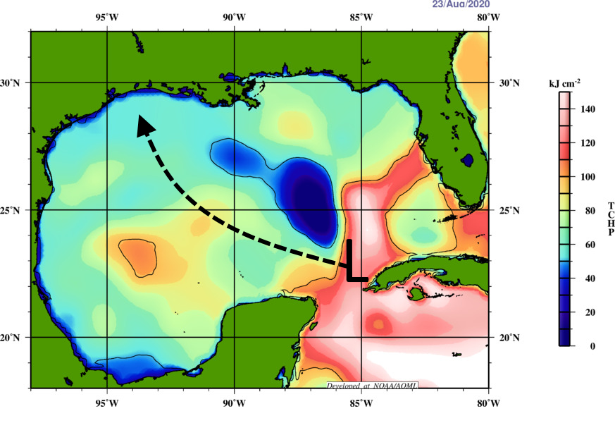
Unfortunately, Laura is going to miss the less explosive “blue” water to its north. (This feature actually predates Tropical Storm Marco). However, it also will not have the very deep pool of warm water that some past hurricanes have had to draw upon. A final consideration is that due to Laura’s relatively fast forward motion, presently 17 miles to the west-northwest, the storm will not be as effected by heat potential as a more slow moving system. Bottom line: The Gulf is conducive to strengthening, but it is not as quite explosive as it could be.
Another factor in intensity is wind shear, and unfortunately that is expected to remain on the low side until Laura nears shore. Add this all up, and the National Hurricane Center now forecasts Laura to come ashore with 115-mph winds, as a Category 3 hurricane. This is a pretty reasonable estimate, but it is only that. Laura could well be stronger, or a bit weaker.
Hurricane Ike
If you’re looking for an analog for what to expect in Houston from Laura, probably the best recent storm is Hurricane Ike. This storm made landfall on the east end of Galveston Island in September, 2008, and followed a track up the western side of Galveston Bay. It had maximum sustained winds of 110 mph.
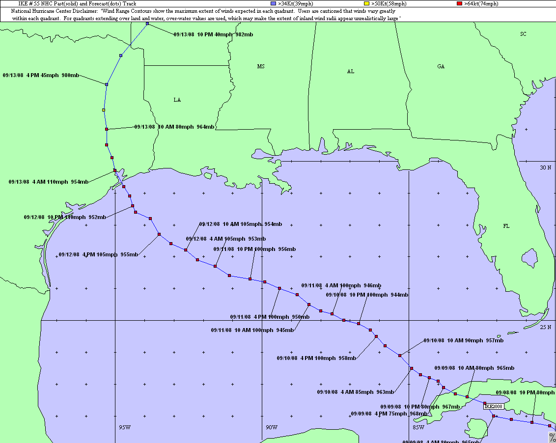
It is not a perfect comparison, as Laura probably will be more intense as it comes ashore with more damaging winds; and Ike was a larger storm so it produced a significantly more powerful storm surge we will probably see with Laura. But the reason I want to show the graphic below is that, very roughly, it provides a way to set expectations for Houston and Galveston.
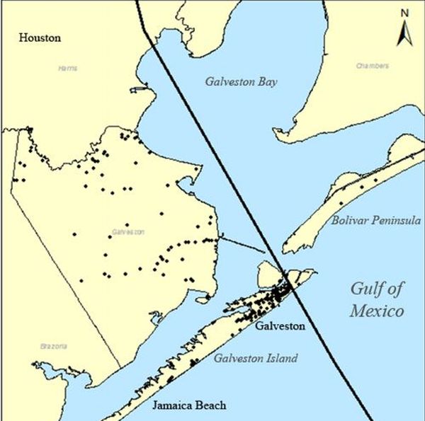
If Laura’s track ultimately is east of this line—which for now seems likely, but is not guaranteed—effects in Houston ultimately will probably be less significant than Ike. If the storm tracks along, or west of this line, winds and potentially even surge in Houston will be worse. It might not be too strong to say “unimaginably worse,” because Houston has not really experienced an intense wind storm since Hurricane Carla in 1961. This would require sheltering in a safe place. If you’re looking for a worst case scenario for Houston, it would be a landfall near Freeport or San Luis Pass.
For those who did not live here at the time, Hurricane Ike caused $30 billion in damages in Texas, mostly due to storm surge. This report provides a good analysis of the storm’s winds. It can be summarized as: one-to-two weeks of power outages, lots of downed trees, and roof damages. So like we said, a storm east of the line above would probably result in less of that. West, and all bets are off.
We will update again by 10:30 am CT. By then we probably can begin to talk realistically about what most of Houston will experience in terms of winds, waves, and rain; and when to expect it.

How far inland might we expect to see damaging winds and/or power outages? For instance, how would Conroe fare?
I am 53 miles inland, but I see people from Missouri City saying they are evacuating. I would like to know what to expect here. 107 people died and millions were stranded evacuating from Rita, and if the storm had stuck to its Houston track, a lot more evacuees would have died.
You don’t need to evacuate unless you’re in one of the areas evacuation is called for. In hurricane Alicia there were trees down and some street flooding. Lots of damage to areas that regularly flood. Lots of glass raining in downtown. The worst thing back then was lack of power for 18days and no phone for 21 days.
Depends on which side of Conroe you are. East side feeds a lot of electricity from the Beaumont area (or at least used to, it may have changed). Rita took out a lot of infrastructure and Conroe saw rolling brownouts for about a week. Areas further east didn’t see full restoration of power for 10 to 14 days after the storm.
As far as damaging winds, hurricane force wind s will make it deep into the state based on the rapid pace the storm will be moving.
We lived in The Woodlands during Ike and it was crazy. Not as bad as being on the coast obviously, but we had a huge tree down in our backyard (as did most of our neighbors) and were without power for 8 days. We slept in the closet overnight as it was coming through and I’ll never forget the howling winds that lasted for hours.
Ike went up I45, so you must have been in the eyewall. In West Houston winds were not bad at all. We had worse during a Christmas storm in the early 00s. We did not lose power, although neighboring areas certainly did, and the water pumps throughout the city were powerless. I have very big doubts that power will stay up this time around because we get a lot of short power outages whenever the wind picks up.
That Christmas storm you mention was actually the early 90s.
If it’s the one I’m thinking of, it wasn’t even early 90s—I remember we had a monster storm + freeze over Christmas of 89 that set a bunch of record lows and blew up everybody’s attic pipes. We were hauling water from a neighbor’s swimming pool to flush our toilets.
Lee
You are absolutely right. It was 89. I thought my oldest had just been born, but I now remember, it was nieces and nephews who were the newborns for that storm.
Oh yes! We were in Pittsburgh for Christmas 1989 and we came home to busted pipes and water all over the house.
I’m in Katy and I remember Ike as the storm that destroyed part or our eaves (fascia, actually)and made it possible (this is our fault for not fixing it right away, lesson learned)for wildlife to go into our attic…that took a long time to get removed. I also remember I didn’t sleep that night at all due to the wind howling…….but surprisingly we didn’t lose power…..that may not be the case this time….
About half-way to Dallas if the storm hits Galveston Bay directly. Less so if it hits closer to the Louisiana border. There is a high probability of power outages in your area, and a lower, but non-zero probability of severe wind damage.
I lived in Kingwood during Ike, and we had sudtained winds of over 100 mph at times. We also had the eye pass over us though.
I live at Lake Livingston on the water how is it going to be here
What is the width of the outer bands? Thanks guys for keeping us updated. Praying for all Texas coast. Be safe.
What about Hurricane Alicia? We experienced hurricane winds during hurricane Alicia in 1983.
Alicia was a category 1 if I remember correctly
I stand corrected it was a Cat 3 at landfall but it was a very small storm which was moving slower than this storm is and weakened pretty quickly after landfall. I was only 8 at the time so give me a little grace. 🙂
Bad news, but that’s the cost of living here. Nice informative article, but you did miss hurricane Alicia, 1983. That was an intense wind storm (Cat 3) that made landfall between Freeport and San Luis Pass.
Thanks Eric. We are on Tiki and trying to decide what to do in the next 24 hours. Left during Ike and the damage for Tiki and our house was caused by the surge with water 5-8 feet across the island. Winds between Ike and Laura seem to be about equal if Laura comes no closer than Bolivar, but surge will be significantly less….therefore the dilemma on what to do.
Tiki Owl, if I lived on the coast, I’d be moving inland for this one. Good luck.
If I were in your position I would leave, sounds like this o e could be a strong Cat 3, even read it could get up to be a 4 or 5. One of those better safe than sorry situations but please don’t wait too long to leave, because of traffic, etc, plus its weird now when traveling with covid restrictions, can’t just stop anywhere for potty breaks.
I grew up in BV. I would leave.
Great insight. Another analog could be Alicia in 1983. Borderline Cat 3, small compact storm that formed in the central gulf, and moved right up 288.
Wondering what kind of effects we will feel in Cypress area?
During Ike, in cypress, we had trees down and no power for 7 days at our house. Minimal flooding. Mostly wind damage.
Yeah…I was without power for two weeks, off of Grant Rd. The wind sounded like a dragon coming through the trees, snapping 80’ pine trees like matchsticks
How will current forecasts affect Brazoria County?
Hi Eric, we live in Bridge City, TX, not terribly far from the TX/LA border. Ike caused a significant storm surge here in Orange County, that flooded our entire town. It put approximately 2’ of water in our home. From a storm surge perspective for Orange County, should we expect to see “Ike levels” again from Laura? Just wondering what differentials we could expect for her speed and size relative to Ike. Thanks so much!
Here’s hoping Laura does much less damage than she could. We might still see no really significant problems in Houston, but somebody will. Best case scenario is landfall in a less populated area, a smaller than expected storm surge and rapid movement of and disintegration of the storm. But don’t count on it. Old saw. Hope for the best, prepare for the worst. Good luck everyone.
What about areas like Rosharon? Should they evacuate?
Susan, for inland areas like that I’d say don’t evacuate unless you’re in a house that is prone to flooding or that can’t withstand wind, or if someone in your family has medical needs that would be compromised by losing power. If your house and family can take it, you’re better staying put and riding it out. Of course you’ll want to have all the supplies and food you need to be self-sustaining during and after the storm. Pro tip: fill up big containers with tap water for things like bathing and flushing toilets, in addition to your drinking water stash. You also might want to evacuate after the storm if you’re going to be without power or tap water for a long period of time.
I’m trying to figure out what the wind will be in the Cypress, 290 area.
How often does the NWS update their alerts?
I understand this is all subject to change, but currently the watches don’t extend west of Harris county. Ft Bend has a just a hurricane local statement, Houston/Harris a TS watch, Brazoria a split hurricane/TS watch for the shore/inland.
Can we really expect it to be that calm in Sugar Land/Richmond/Katy?
Eric mentioned that we should expect the cone, and I would suspect, the watches/warnings, to shift west at the 10 AM CDT update.
Are you saying the SugarLand/Richmond/Katy area are in striking distance of the core? We weren’t here for Ike, we actually moved her just in time for Harvey and that wasn’t bad for us at all but I grew up CC and evacuated a couple of times b/c of how close we were to the water. Just wondering if we should leave just so we aren’t days without power?
When you say the winds will require sheltering in a safe place, what does that mean? I’m near Ellington field and the Beltway. We are not planning to evacuate. Is that a bad idea? I’m not worried about flooding, but not sure how concerned I should be about wind.
Amanda, I used to live down there… the apartments at Dixie Farm Road and 45.
I’d say it depends on what kind of a structure you’re in. If it’s a trailer or flimsy house, definitely not a good idea for a wind storm. A well-built house or apartment building should (hopefully!) be able to stand up to 115 mph winds, though there might be some roof damage (especially if the roof is old). It’s a good idea to identify an interior room or closet where you can shelter if the wind gets really bad.
I believe the saying is “run from water, hide from wind.” In other words, if you’re worried about storm surge or flooding, evacuate; if you’re worried about a windstorm, shelter in place. You’re safe from storm surge where you are; the only question would be inland flooding.
I lived in that area when Ike hit. Mostly a lot of wind damage occurred. They called for a mandatory evacuation in Pasadena, but we stayed put. Power was out for about a week or so. It sucked bc it was hot as hell. I wouldn’t evacuate, but DEFINITELY STOCK UP on canned goods and water.
I hope that only those told to evacuate will do so. When everyone in the greater Houston area tries to evacuate, it makes for a Rita situation.
Tracie, I’m in SW Houston near Stafford. I left during Rita. It was horrible. Took me 4 hours to get to Tomball!!! I’m staying put this time, even tho the winds of Ike almost drove me crazy!!.
Relatively recent transplant to HTX (SW loop) here, so unclear on one point: I thought the chances of storm surge in Houston itself were basically zero, barring an extinction-level event and that the risks were more in terms of flooding and wind. But one sentence fragment describing the worst-case scenario above threw me off this: “potentially even surge in Houston.” Is that referring to the general Houston metro area, including areas within the more southern surge zone? Or am I wrong about most of the central Houston loop being too far from the coast for surge risk? Thanks for any local knowledge on this one.
DF, pretty positive he was talking about the Greater Houston metro area — Galveston, Bolivar, Freeport, and all the the little towns along Galveston Bay. Don’t forget that the bay itself is subject to pretty significant surge when a hurricane “sloshes” into it; water can even back up into the Port of Houston on the east side. You don’t have to worry about storm surge anywhere near the Southwest Loop, though. But if you’re talking Meyerland, they have significant problems with inland flooding.
I believe the surge he is referring to in Houston is mainly along Galveston Bay and the Houston Ship Channel. But the surge can also back up some of the bayous that drain into the bay. Although the bayous shouldn’t be too big of an issue with a fast moving storm with manageable rain totals.
How should the Clear Lake area fare?
Any idea what it will look like for Baytown?
should katy evacuate?
We live and Katy and were here for Ike. Some areas list power for a week and there was strong winds but not much in the way of flooding. My family doesn’t plan to evacuate but we have supplies in case of a sustained power outage. The biggest problem if people in Katy evacuate is making the roads more congested for those are have a mandatory evacuation.
Probably no.
http://www.h-gac.com/hurricane-evacuation-planning/default.aspx
What about Sugar Land? We lost power to 11 days after IKE. Miserable then,…
How long are we expecting Laura to sit over Houston?
Anyone knows what to expect in the Rice-Military / Washington Avenue area?
Be interested in reply. We lived in Crestwood on West Cowan from 65 to 93. No problems with water until lots of building started in the late 80s. Concrete adds to flooding. Good luck. B
I live in that area and was there during Harvey. There were pockets of flooding throughout the area, but it was highly dependent on what part of the neighborhoods you were in or trying to drive through. It sounds like the rainfall for Laura won’t be near as high as Harvey, but it sounds like high winds and the potential for loss of power will be more of a potential issue.
We moved from downtown to Katy in 93. There was a hurricane that devastated Houston and east. People were evacuating on I10 west. The highway was packed. I don’t think we even had much rain out here. Does anyone know which hurricane that was? B
All the people asking what to expect in certain towns and neighborhoods, or with comparisons to past storms, should realize that there is no way to compare. Neighborhoods that didn’t flood during Ike or Harvey flooded during Imelda. Speaking of Imelda, it was barely noticed, until the rain started and flooding began. Other storms that were hyped ended up being not much at all.
For most of the actual city, the best strategy is to stay off the roads, bring your pets inside, and make sure that porch, patio, and lawn items are inside or secured so that they don’t launch through a window. Any big 24 hour organizations, such as police, hospitals, fire department, hospice, and such will still be open, and if you work there, they are definitely making plans for a team to stay overnight coverage if roads are flooding.
Otherwise, from my experience in Ike and with Harvey, the best advice is if you have a cell phone, make sure that it is charged. If power goes out, and home phone goes out, you will at least have a way to call in case of emergency. Also, withdraw a few dollars in cash. I remember when Ike hit stores re-opened very quickly. Kroger had pallets with ice, batteries, flashlights, as well as most regular grocery items. But, if credit/debit card systems are not working, having cash is a big help to get some supplies.
Great advice Jason. A strong hurricane can do incredible damage far inshore if it holds together for long. I recall driving through Charlotte, NC after Hugo and was amazed by destruction. I stayed in Laurel, MS with parents for Katrina and town (about 100 miles or so due north of coast) was smashed. It took two days for us and neighbors to cut downed trees from roads so we could get out of subdivision to main streets cleared by National Guard. No electricity for weeks and even cell phone service down for most of southern half of state. Could not get gas (no power for pumps) until we reached Monroe,La on our drive home to Shreveport. Major roads were blocked and being cleared all the way to Jackson, MS 5 days after storm passed. Be prepared even if you are well inland from storm.
Jason, loved your first sentence. Questions asking how it’s going to be in their particular neighborhood are just ridiculous. No one knows! Best case scenario is that Laura magically disappears. Yes I know that’s ridiculous, but I can still wish.
More words of advice echoing others here, if you are on a barrier island or near the beach with direct exposure to the ocean or tidal waters, get out now. If the storm alters path or diminishes, nothing lost but preparedness for the next time. But, remember Katrina. A cat 3 at landfall. Near LA/MS border with sustained winds of 125 miles an hour. The storm had reached a cat 5 prior but diminished just prior to landfall. Nonetheless, New Orleans took a glancing wind event on it’s east side but the collapse of the levee system created the main damage. Many people associate New Orleans and the flooding damage with Katrina but forget or did not see the extent of destruction from wind and surge damage from the Mississippi border with Louisiana all the way east of Mobile, AL. Most of the Mississippi coast line is paralleled by a rail line about 1/4 to1/2 mile north of the coastline. The railroad bed is elevated on a dirt and gravel levee about 15’ in height. Almost every structure in Mississippi south of this railroad levee was destroyed. Nothing was left but foundations, unrecognizable heaps of debris, and shipping materials from the port including large ships blocks inland. Even the bridges and highways were washed away. North of the railroad, the flooding continued if you were near a river, creek, or bayou. Wind damage destroyed thousands of other structures in LA, MS, and AL. Initially, there was no electricity, phones, cell service, effective law enforcement, or available medical care. Hospitals near the coast were not functional. Emergency services could not access areas with no more existing transportation infrastructure. Much of the southern parts of all three states did not recover power of phones for weeks. Food was scarce and the military and red cross provided the only available meals, water, and ice. I could go on… This was not a worse case storm. It weakened significantly prior to landfall. A path further west of New Orleans may have spared parts of Mississippi and Alabama but the effects to the heavily populated New Orleans area may have been exponentially worse. Please prepare now and get out if you are near the coast or areas susceptible to flooding.
I live in Western North Carolina the mountains. While seemingly not impacting us, I wanted to thank you for such a well written clearly informative article. It gave me a clear understanding of what you expect, including all the unknowns.
Thank you.