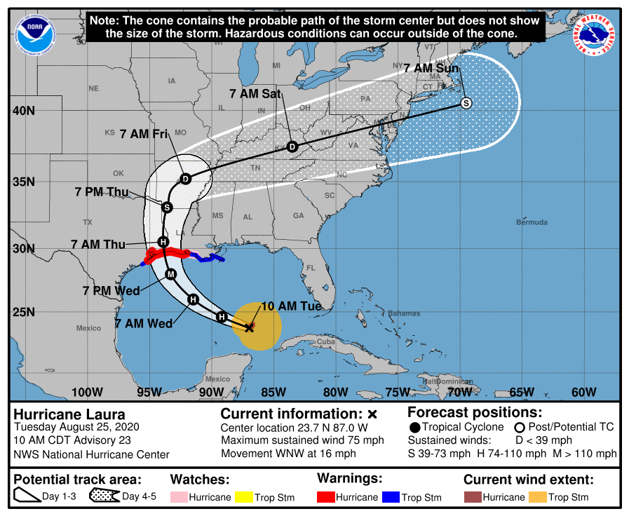
POSTED AT 10:30 AM CT TUESDAY: In its 10 am update, the National Hurricane Center has modified its forecast track for Hurricane Laura, and has shifted the storm’s landfall slightly closer to the Houston-Galveston metro area. We remain within the cone of uncertainty, and need to be prepared for the possibility of additional westward shifts in the track this afternoon. We are still in line for anything from a glancing blow to direct major hurricane landfall. Bottom line: This is time for preparedness and action, not panic. This is a very serious situation that all residents should be following closely.
Local effects
The location and intensity will play a major role in the effects Houston sees. Even a track movement of 20 or 30 miles can make a big difference in the effects we see (I discussed this in a post earlier today). Due to the uncertainty, for the discussion below we will provide a forecast for Laura’s effects in Houston based on the current National Hurricane Center track, and those for a reasonable worst-case scenario should Laura track further west and make landfall along Galveston Island.
Winds
At this time winds are our greatest concern. They are likely to be strongest near the storm’s center of circulation, and to its immediate east. The most recent run of the HWRF model depicts a probable wind scenario for Laura should the storm make landfall near the Texas-Louisiana border. As you can see, winds over the Houston area would generally remain near or below Tropical Storm intensity, especially west of Interstate 45.
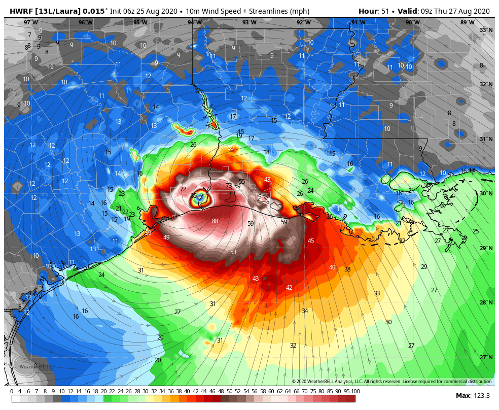
If the storm makes landfall over Galveston Island, the core of strongest winds would go inland along Interstate 45. This would provide widespread residential damage and knock power out for weeks, for many.
Storm Surge
This is our next biggest concern for the metro area. Laura is smaller than Hurricane Ike, and probably will come in east of its landfall location, so a surge along Galveston Island, and along the bay, probably will be less than the region experienced in 2008 under most scenarios. Here is the hurricane center forecast for surge along the current forecast track:
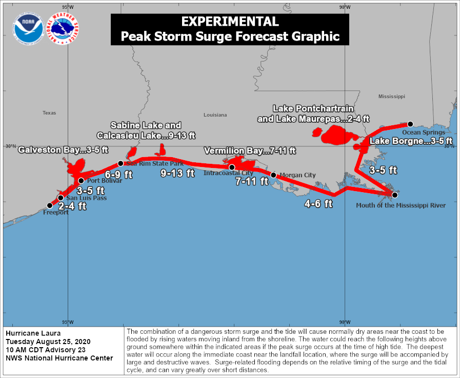
If the storm tracks further west, it looks like a storm surge of 6 to 10 feet along Galveston and Galveston Bay would be a reasonable estimate.
Inland rainfall
This is a much lower priority due to Laura’s forward speed. As I hope you understand by now, this will not be another Hurricane Harvey. In terms of rainfall, we can probably expect 1 to 3 inches with the current track. Should Laura make landfall further down the coast, we can probably anticipate widespread totals of 6 to 10 inches, with higher isolated amounts.
Should you evacuate?
If you live along the immediate coast and are under a mandatory evacuation order, as Galveston Island is, the answer is yes. You should heed local officials who are making difficult calls.
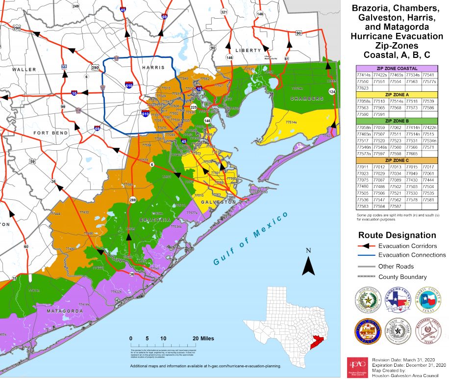
After that, it’s really a personal decision for you and your family. How high is your risk tolerance? Are you willing to spend several very intense, and yes, scary hours in the middle of a hurricane? Do you have a safe place in your home to shelter within? Can you survive without power for several days? The age-old advice during a hurricane is that you evacuate from a storm surge, but take shelter in your home from wind. Effectively, for the Houston area, this means the closer you are to the coast, the higher your risk for surge. These “zip zone” maps (click here to download medium, and large-sized maps) show the risk in this area by zip codes.
All evacuations should be completed by Wednesday, at noon. This is about the earliest reasonable times that winds would arrive in the Houston metro area.
We will update again by 2:30pm CT.

What are the latest projections from the European model?
I’m trying to find a place online where I can see the latest Euro ensemble runs and spaghetti plots. I haven’t had much luck. Does anyone know a url that would have that?
In years past, I had a place that showed a whole bunch of different models runs. It might have been at weather underground, but they no longer have anything like that that I can see.
Weathernerds.com
weathernerds.org
http://www.tropicaltidbits.com
I’m at tropical tidbits all the time, but I don’t see an area with a bunch of model runs. I must be missing something.
I’m an idiot. They are there.
spaghettimodels.com has all of them, not sure how frequently they update the euro models though.
Thanks guys! These work. BTW, it’s weathnerds.org and not .com
Spaghettimodels.com. Has a wealth of links to different data, including NHC and various other models. It’s a great one-stop shop.
My Ike PTSD was starting to flare up, but for the moment the calm analysis that you guys always provide has tempered the anxiety. I and many other Houstonians will be anxiously awaiting the next update. Thanks for all you guys do.
This will be my first storm as a homeowner, is this a board up situation?
Depends on where you live.
If you have precut windstorm panels that you’ve never put up before, it’s going to take you longer than you think, especially if you have jackscrews instead of clips. Today is a good time to at least get started—consider putting up your panels on the sides of your house that don’t face the street today, and then if things continue to look grim tomorrow AM, put the rest up then.
If you’re going to have to drive jackscrews through hardiplank, consider making an emergency run to Lowe’s/HD and get a corded drill. My garbage cordless drill could do 2-3 panels (so about 24-48 jackscrews) on one battery pack, and I’ve got like 20 windows. A corded drill was a lifesaver.
That is very, very location dependant. I’m on the north side in southern MoCo & we aren’t boarding up here. Proximity to the coast & to projected landfall location determine if that’s a good choice.
I don’t understand why y’all use the zip-zone evacuation map when you talk about the risk of storm surge. Zone A includes Kemah/San Leon and west League City. Surely those locations do not have an identical risk of storm surge?
First, this ZIP code map is published by the regional Houston-Galveston Area Council and not by Eric and Matt. But, it is designed to be a rough grouping for people to evacuate in stages based on proximity and capacity of the evacuation routes.
Yes, different locations within the colored areas do not have identical risks of storm surge but we’re talking about moving people in stages, not where flooding from storm surge is happening.
I know who publishes it and what it’s designed for. That’s why I don’t understand why Eric and Matt say “look at these zip zones for storm surge risk by zip code.” Seems to me like zip zone maps aren’t the most useful graphic for knowing where and how much storm surge there will be, unless I’m missing something.
I think it’s to prevent the “Should Katy evacuate” questions and the like. If you live in a spot that should evacuate, you likely know it or you will soon.
A Clear Creek runs through it. A sufficient surge in the Bay means that it can’t drain, and might even wash back up a little bit. CC thru west League City doesn’t have alot of room to grow. Check out the gauges at Bay Area and I-45, there isn’t much headspace already.
You talk about possible shifts of 20-30 miles – are there past examples to cite to help judge how much storms have diverged from forecasts like that in the past such as Ike? Thanks for all you guys do.
2/3 of storms make landfall within the cone as projected 48 hours out. Therefore 1/3 of the storms make landfall outside of the cone. The forecast for this storm has consistently shifted West. Therefore there’s a high likelihood that it will make landfall West of the current center line. Ike was actually the rare storm that actually stayed close to the projected center line. The European model had it striking Galveston Bay 16 days before landfall (when it was still an Invest (area of potential development)). I was sitting at my brother’s house in VA as Gustav was in the Gulf watching the system that became Ike.
And on the HWRF model, are those wind speeds in mph? I thought a category 3 had stronger winds than that…I’m confused.
Notice in this image that it shows the eye over land, so wind speeds will ease ever so slightly due to greater friction. But, also note in the lower RH corner, the max is still showing 120+ mph.
The models usually report in knots, multiply by 1.15 to get mph.
Sorry, the embedded HWRF picture is in mph already.
Eric, what effects should areas northeast of Houston, i.e. Humble, Kingwood, Atascocita, etc. expect from the storm?
It will vary for our area (I live in Kings River, near Lk Houston) depending on the landfall track. As shown in the wind graphic above, we would be on the weaker side and experience very manageable winds. An I-45 landfall track puts our area in the NE quadrant and, well, just shift what you see in that image over a couple of inches to give you an idea. It would be much worse and we would see tropical storm force winds with hurricane force gusting.
I’m asking the same thing.
Fox news and weather channel both reported NO CHANGE in track on 10 am update yet you say there is. Don’t understand that. If they wanted to hype this there would have been change. So very confused on all this ….. please explain. Ty
Here’s what the local broadcast mets are saying: Space City Weather: “slight movement.” David Paul, KHOU: “slight movement” Elita Loresca, KTRK: “Nudged a little to the west.” Fox 26: “Bottom line, moved a bit west” I can’t find a tweet from KPRC or KIAH, but Eric & Matt aren’t alone in their assessment.
How will Marco impact Laura? It seems Marco popped back up – will it potentially cool the water before Laura makes landfall?
Cold water upwelling only makes a different over the open Atlantic. The GOM and Caribbean are very shallow seas so there isn’t much cold water at the bottom.
Ahh ok. Thanks!
We have an outbound flight out of IAH on Thursday at 7pm, what are the chances it will leave on time? Would you advise trying to change the flight to Wednesday or expect the delayed flight on Friday?
If Laura flies through here as it is expected to, you might be fine. Just keep checking your flight updates.
After Ike IAH was shut down for over a week (without the COVID-19 Pandemic issues). I would leave early or not at all.
Chances of your flight leaving Thursday evening are nil. You’d have a better chance of getting out on Wednesday than on Friday.
Try to change your flight to today or early tomorrow if you can. Otherwise, you may be stuck here in H-town with all of us, no power, and some angry mosquitoes. August is the pits.
As far as Cypress, I know for Ike, we had to board up our house. Is this the same situation?
I’m in Cypress. Been through many storms. Won’t board up unless track shifts is into NE quadrant even then I am only worried about South and East facing windows.
Why is the NHC still showing landfall near/on the Texas/Louisiana border? There is a bit of a difference between NHC track and “likely headed to the upper Texas coast”?
The GFS is still heavily leaning toward a TX/LA border solution, while the Euro is going further west. For whatever reason, the NHC is leaning more heavily on the GFS this year.
One tip from a multiple-storm veteran.
Consider riding this out if you have a well constructed structure to live in and are not under evacuation orders. If your home loses power, you can always leave Thursday afternoon after things calm down. Just have a full tank of gas.
Please keep the freeways clear for those who have been ordered to leave.
What is the likelihood for tornadic activity as a part of this?
Tornadoes are always a part of hurricanes. My experience and memory says they are typically weaker and short lived vs the ones produced when a front line barrels through.
Well I’m in Cypress and our neighborhood got the tornado last year during Harvey. And for Ike, we were out of power for almost 2 weeks.
Should we be concerned at all with the storm surge backing up the bayous?
UTC is 5 hours ahead of Houston now. So, if a model says it was initialized at 0600z, then that would 0100 our time right? Seems simple but I just want to make sure.
Yep.
Thank you for what you do!
Super minor point, but only the City of Galveston requires mandatory evacuation. Currently the remainder of unincorporated Galveston is not under a mandatory. Bolivar is currently voluntary. I don’t see anything On Galveston County website about it’s evacuation orders.
Thanks again!
Hey guys, love the site and level headed reporting. Wondering if you could talk about the duration of the storm? How long will it last as hurricane force winds but also how long might we just have regular thunderstorm type activity associated with it. Wondering if it’s going to be like, arrive late Wednesday, and be basically gone by midday Thursday or if we are in for 2+ days of storms. Thanks!
Looks to be a quick mover. Check here for more info:
https://www.cyclocane.com/laura-storm-tracker/
Many similarities to Rita, though obviously not as strong. Hoping Laura turns and shear can weaken the storm a bit before landfall.
Eric,
Fifteen years of reading your work, and once again I find myself looking to your perspective for good solid analysis.
It appears the wind field is relatively small, which is a very good thing since we are already (so far) on the weak side of Laura.
Is that observation correct or am I missing something?
It appears to me that the next data driven updates will be the most important: Is the storm still shifting West or not?
Thanks for all the work you do.
Kind regards,
hunter
PS, do you still have access to that moisture content imagery? If I recall, that is an extremely good indicator of future storm strength.
When on Wednesday will we begin to feel significant effects of Laura, such as high wind and heavy rain?