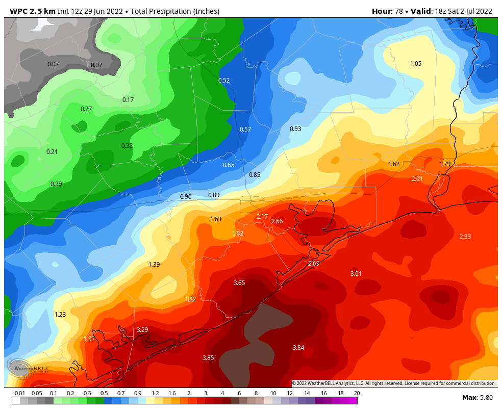
Houston’s warmest June ever is going to end much cooler than it started. With an increase in cloud cover, and at least decent daily rain chances, the next four days will generally see high temperatures of only around 90 degrees, give or take. The bigger question remains rain totals as a low pressure system approaches the Texas coast. Between now and Saturday I would expect 0.5 to 2 inches of rain for inland areas north of Interstate 10, and 1 to 4 inches for areas closer to the coast. But there will be wide variability across the region, and a lot still depends upon the movement of the tropical low over the next few days.
Wednesday
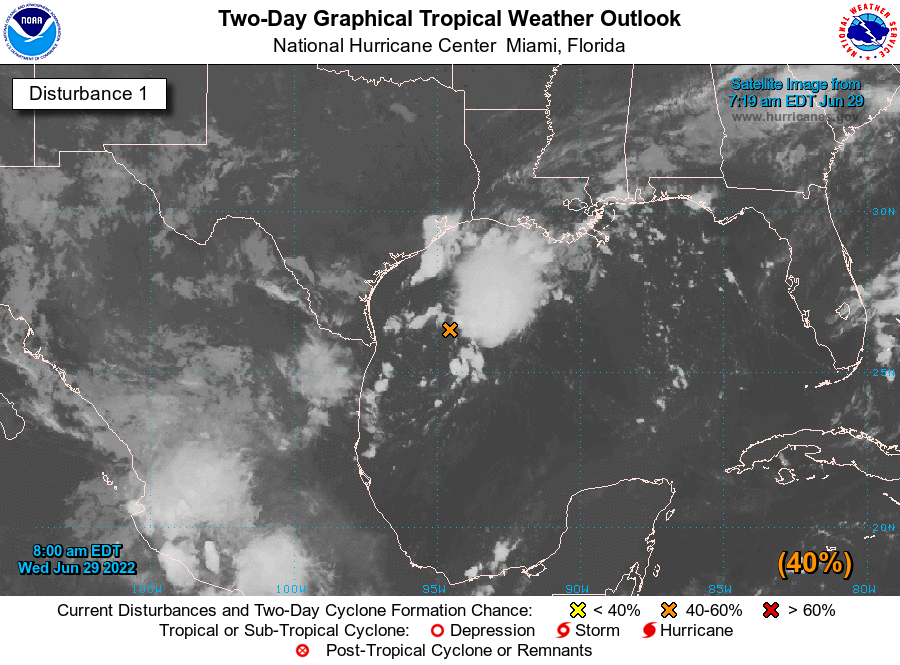
The aforementioned low pressure system is a couple of hundred miles due south of the Texas-Louisiana border this morning, over the Gulf of Mexico. And that’s where the bulk of the rainfall is, offshore. Still, we’ve seen coastal areas getting clipped by rains moving inland early this morning, and that could happen again this afternoon and early evening. If you live inland, north of Interstate 10, rain chances are less today, but not zero. Highs will generally reach the low 90s, beneath mostly cloudy skies. But if some sunshine pokes through this afternoon, a few locations could reach the mid-90s. Light winds (except in thunderstorms) will shift from the northeast to southeast later today, and rain chances may slacken over night.
Thursday and Friday
These two days still look like the best time for moderate to heavy rainfall to fall along upper Texas coast. This is when the tropical low pressure system—which has a 40 percent chance of becoming a tropical depression, the National Hurricane says—should come onshore somewhere along the middle Texas coast. Again, the most favored regions for heavy rainfall will be coastal counties, including Matagorda, Brazoria, and Galveston. However, the best chance for inland rainfall will also come on these days, as the tropical system marches inland. Our rainfall totals will ultimately depend on whether the system makes a northward jog, in which case some coastal areas could see 5+ inches. At this point, we just can’t say for sure.
The increased cloud cover and widespread rain should help to keep temperatures in check, with daily highs perhaps not making it beyond the upper-80s for a lot of locations. Enjoy the reprieve from the heat, which we certainly earned after a torrid June.
Saturday, Sunday, and Monday
For many this will be a holiday weekend. It is looking like we’ll see a carryover of rain chances into Saturday morning, but at some point they’re going to end and our skies will likely turn sunnier. Highs on Saturday will be around 90 degrees. Sunday looks partly to mostly sunny, with highs in the low 90s, and the Fourth of July should see partly to mostly sunny skies with highs in the mid-90s. We can’t entirely rule out a fleeting shower on these days, but I’d put the chance down in the 10 percent range. Note that while Harris County Commissioners did vote to enact a burn ban on Tuesday, fireworks will remain legal in the unincorporated part of the county.
Next week
Most of next week will likely see highs in the mid-90s, with mostly sunny skies, and precious few rain chances. So be sure and top off over the next several days, if you can.
Monday night – lots of thunder, no rain at the house
Tuesday – Some promising clouds, no rain at the house
This morning – lots of thunder, rain on the drive in, no rain at the house
I think I see a pattern here. No rain at the house.
(And what was that 97 degree high on the news this morning? – – with all the cloud cover??)
Got sprinkles as I was heading off to work in Southern brazoria County. All for as much rain as possible.
Come on rain, ….now for the “serious stuff” 🙂
What time, where, how much, when will it stop, do I cancel the following – backyard party, dog grooming, yard sale, flight to Port Arthur, invasion of Arkansas, relaxing Saturday at Ikea…and finally coordinate evacuation routes out of Katy.
Is the storm expected to make it inland northwest of Houston? That is what we need.
My unofficial frog rain gauge had us at 1″ of rain on the far west end of the island this morning.
I’ve noticed a trend over the last few years. The models trend to far west. Last year I looked at all gulf storms predicted vs actual tracks. Nearly all missed to the left.
I wish you would comment on Disturbance #2 which now seems to be pointing our way.
The models seem pretty content with it going due west into Central America, never once even coming within 1,000 miles of us.
Oh, I see what you’re saying now. I thought you meant Depression 2.Carry on.
I’m all for a moderate amount of rain over the course of several days. We need the water!