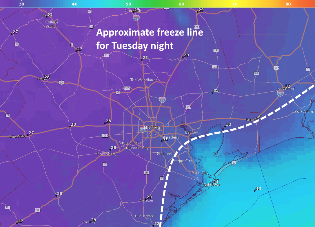
Houston’s temperature dropped below 40 degrees on Tuesday morning for the first time since February 12, and our lows this morning will be quite a bit warmer than the next two mornings. The region’s first freeze since January is on tap for tonight for most of Houston except the coastal areas.
Tuesday
Today will be a cold one, without a doubt. Skies should remain mostly cloudy, and this will likely limit high temperatures in the mid-40s. Brisk, northerly winds at around 15 mph will push wind chill temperatures into the 30s—so you’ll definitely want a jacket at the very least. The radar is showing some very spotty snow flurries and sleet to the west of the region this morning, and this area of moister air aloft will move over the Houston region between about 8am and noon. However, the air nearer the surface of our region is very dry, so while we can’t entirely rule out a few sleet pellets or snow flurries this morning, they’re unlikely.

Tonight will be the region’s coldest since mid-January, with most of the area seeing a light-to-moderate freeze .The usual precautions for pets and plants apply, although it probably won’t be cold enough to threaten pipes. The record low for Nov. 14 in Houston is 28 degrees, and I suspect the city’s official station at Bush Intercontinental Airport will come close to that.
Wednesday
Another chilly day, although sunny skies should allow high temperatures to climb to around 50 degrees. Atmospheric conditions will continue to allow colder, northern air to move into the area. Lows Wednesday night should be about as cold as Tuesday night, or perhaps a degree or two warmer. This really is an Arctic air mass.
Thursday and Friday
We’ll see a warming trend heading into the weekend, with highs Thursday in the mid-50s and Friday in the mid-60s. Sunny skies will prevail during the day, and clear nights will allow for lows generally in the 40s.
Saturday
A fine day, with partly to mostly sunny skies, and highs of around 70 degrees. We should start to see moisture levels rebound as winds return from the Gulf of Mexico, but this still looks to be a really nice fall day.

Sunday and beyond
The forecast for Sunday is a bit less clear, as returning moisture levels will bring some clouds, but at this point who knows whether we’ll see partly or mostly cloudy skies. Regardless, highs should be around 70 degrees. We can’t entirely rule out some scattered showers, although they seem more likely a little later next week.
A front on Monday-ish will bring the next real chance of rain showers into the region, although I’d be lying if I said we had a good handle on how much, or how high the rain chances will be. If you’re wondering about Thanksgiving, right now I’d peg it as a day in the mid-70s, but I’d be a turkey to try and give an exact forecast with all the uncertainty right now. I’ll take a deeper dive into that forecast tomorrow morning.
Fundraiser
Just a reminder that our annual fundraiser is ongoing. I spoke with our supplier, and it turns out they made a mistake in offering umbrellas for sale this year (they normally don’t drop ship them to individual customers). They’re going to do that especially for us, but they may not offer umbrellas next year. So if you want Space City Weather brolly, this is your chance.

This seems early for weather this cold. I hope it doesn’t portend a cold winter for us.
As always, appreciate your and Matt’s morning reports with my first cup of coffee…will look forward to Spring…thanks!
thinking Thanksgiving will be a rain out, Mother Nature apparently does not like holidays…. LOL i.e. July 4th floods, Halloween storms…. Thanks again guys for all you do !!!!!
When will the winds begin to subside? That can make a difference to plants, etc.
When will the winds begin to subside? I’m trying to figure out exactly how many plants to cover.
🙂 Cold, cold, cold, and Chicago-style wind. So, in their successful effort to prevent a 90+ high last week by spraying the “Official NOAA IAH Thermometer” with cold water (after forecasting 90+ was DONE in 2018), it seems our intrepid no-hype meteorologists overdid their efforts just a tad. So guys, get back to IAH and spray some warm water on that thermometer, please! Low 70s, low 50s would be nice for awhile! 🙂
I see snow outside right now! I’m in Lufkin
I’m in W. Houston and saw a few flakes myself!
same time in memorial
My wife just confirmed to me that the thin bands south of houston are sleet/flurries. She’s in friendswood today.
Sitting at home in League City and not seeing any sleet yet, but will keep eyes peeled!
I’m curious- when is the earliest snow for the Houston area? This has to come close, right??
I was reading this as it started sleeting in Friendswood. I had to laugh.
I live right behind Ellington Field and it’s sleeting pretty hard right now with snow flurries mixed in. This was a surprise. 😊
Do you think we’ll set a record for coldest November this year?
when will the winds calm?
Is it me, or have we had about ten days of sunshine since July? I’ve lived all over the country and nowhere have I experienced as much extended darkness as in Houston. It’s worse than Seattle, in addition than being ugly and flat and without proper sidewalks.
Sebastian – Try the Great Lakes states. No sun from mid-November through February.
I got into my car (which I bought this spring) and while backing out of the garage, I noticed I needed to turn on the heat. Only I couldn’t figure out how to do it on this high-tech wonder. Finally after fumbling with touch-screen display icons only a six year-old would understand intuitively, I saw something. A real push-button that said “AUTO”. Problem solved.
Cars are just getting too complicated these days. To a certain extent, I have to wonder what was so wrong with my dad’s ’67 WV Beetle he drove to and from the commuter train station.
With you buddy…give me toggle switches and knobs…
Air cooled VWs are great, I have a Karmann Ghia that is almost done being restored. But the heat in those air cooled cars is not so great.
My wife saw a little snow flurry in Copperfield this morning at 9:30.
Eric, please help your fans and discuss where an upper level low or surface low needs to form with this type of cold spell in the future to give Houston a chance for 3-4 inches of hevy wet snow like college station had last year or Victoria did with 10-12 inches what in 2004 2006?? on Christmas Eve Thanks Darrell