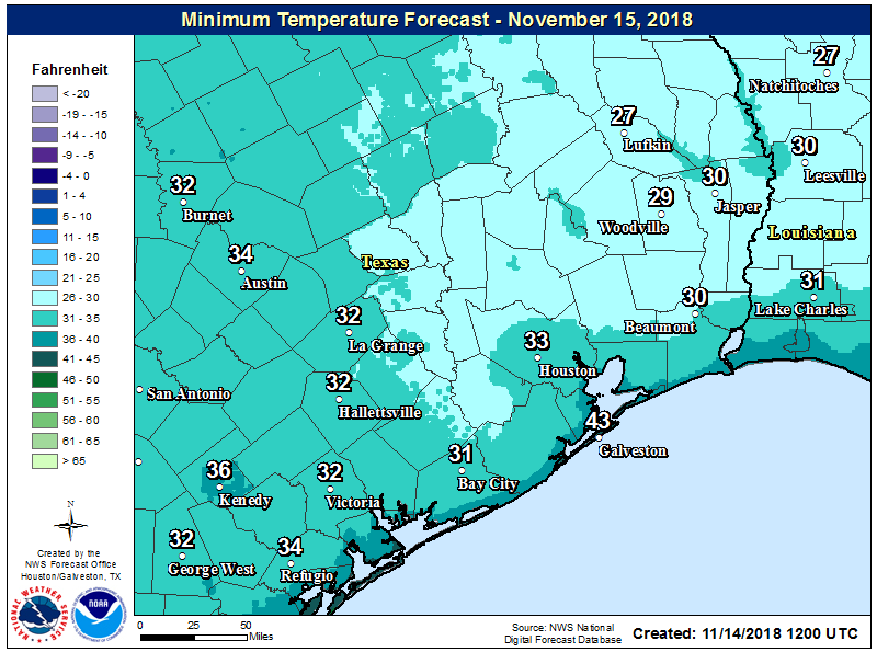
This is quite an early cold spell for Houston. The trace of sleet and snow recorded at Bush Intercontinental Airport on Tuesday broke the record for earliest observed snow at the site, previously set on Nov. 23, 1979. Houston’s Hobby Airport also recorded its earliest trace of freezing precipitation. And although this morning’s freeze for parts of Houston did not set any records, this first freeze has come three to four weeks earlier than normal.
Wednesday
One of the reason it’s very cold this morning is because skies cleared over night, allowing for increased radiational cooling. Those same clear skies will allow temperatures to warm to about 50 degrees today, with light northerly winds, and then once again push lows down to freezing or near-freezing levels tonight. Expect temperatures in the metro area to be similar to to those of Tuesday night.
Thursday
Look for sunny weather, and temperatures should be 5 to 10 degrees warmer, bringing highs into the mid- to upper-50s, and lows comfortably above freezing.

Friday
Still sunny, and a bit warmer. Expect highs in the mid-60s, and overnight lows Friday night ranging from 45 to 50 degrees.
Saturday and Sunday
The weekend will start out sunny, but we expect some clouds to possibly mix in later on Saturday as the onshore flow returns from the Gulf of Mexico, bringing some atmospheric moisture with it. Both days should see temperatures in the range of 70 degrees. Saturday is probably the prime pick, but Sunday should also be fairly nice. However we can’t rule out a chance of rain later on Sunday, and Sunday night, as a cool front approaches the region.
Next week and Thanksgiving
That front may bring a few tenths of an inch of rain to the region, but nothing too significant. Conditions will be a bit cooler for a few days, but the front will wash out pretty quickly.
The forecast for Thanksgiving will depend upon the timing of another cold front moving across Texas next week. Right now, it appears most likely that the front won’t reach Houston before Thanksgiving, which leads to the possibility of a rainy—and potentially even stormy—holiday. (In Houston?!? No way). This forecast is far from locked into stone, but my guess would be daytime temperatures in the 70 to 75 degree range, with a healthy chance of showers.
Have you posted about the long range forecast for this winter? Is it expected to be colder than normal or is this just a blip?
Most likely just a blip.
What? Snow fell in Houston last night and the Eyewitless News Team’s mobile units weren’t there to film it? Shame !!!
I have to admit though, even after living here for almost 40 years I still have to chuckle about people complaining that 30 degrees is cold. They would probably not survive winter where I grew up.
And those people wouldn’t survive summer here. Weather tolerance is relative.
I also got a chuckle when my cousin in Cincinnati texted me complaining about the 95 degree heat index a few years back. I sent back a screen capture of the wunderground.com screen showing the weather station in my subdiviion. Heat index of 113 F.
Well to be fair, many people in this area don’t own winter gear heavier than a hoody sweatshirt, so cold weather can be hard to deal with. When you live where it gets cold regularly, it’s a different story. Similarly, in the midwest, heat waves in the summer bring deaths because there are still many unairconditioned private dwellings.
This is fantastic!!! Now hurry up and get me your shirt so I can make ice angels in it.
Would you show the various WX products, that was shown, a couple of days, a go?