Imelda is thankfully in our rear-view mirror now, and we can begin the process of cleaning up from the latest in a slew of problematic flooding events in Southeast Texas in recent years. Eric and I will take some time to process this and recap it for you in some capacity next week. The weather doesn’t stop, so let’s discuss our weekend.
First, let’s talk about residual Imelda-related issues. Most bayous across central, southern, and western Harris County are back in their banks this morning. We do still have flooding issues in eastern Harris County.
- Greens Bayou is still out of banks downstream of Highway 59 to the Ship Channel. It has crested and should be back in its banks soon at Mount Houston. Greens will continue slowly falling downstream today.
- Garners Bayou is out of its banks at the Beltway, but is falling.
- Cedar Bayou has crested at Highway 90 and is falling. It should crest soon at FM 1942.
- Both the East and West Forks of the San Jacinto River have crested in major flood. They should both be back in moderate flood later today.

The San Jacinto River near Sheldon (above) continues to rise and should crest this afternoon before slowly falling this weekend.
Folks living along the Brazos River, you have nothing to worry about, as rains both over you and upriver were not too significant this week.
Those trying to travel to or from Beaumont, note that I-10 is shutdown at the San Jacinto River due to multiple barge strikes. And it sounds like it might be awhile.
I-10 East Freeway EB and WB at the San Jacinto River all mainlanes are closed. Several barges have impacted the bridges at this location. This is a developing situation that is further enhanced by the river rising. No est. time on reopening. Use SH 225 as an alternate. pic.twitter.com/DLpw4YH4TZ
— TxDOT- HOU District (@TxDOTHouston) September 20, 2019
I-10 also remains closed in both directions between Winnie and Beaumont due to high water.
Today
Not everyone will see showers or storms today, but they will be around. Any storms today will probably move south to north at a slow, steady clip, so they could put down a quick inch or so of rain. While this won’t lead to widespread problems, there could be a handful of locations today that see some short-fused street flooding or some rises on bayous. Again, we don’t expect anything significant. With a good deal of clouds still, we should see highs in the mid- to upper-80s.
Weekend
Both Saturday and Sunday should see a mix of sun and clouds with just a chance of a shower or storm in a few spots. We’re sort of back to typical late summer this weekend. Look for highs near 90 degrees or in the low-90s and lows in the mid- to upper-70s.

Next week
Look for a continued pattern of sun, clouds, and slight storm chance Monday and Tuesday. The midweek period looks perhaps a bit more unsettled with slightly better shower and storm chances. Right now, we don’t expect anything too serious from that, but we’ll continue to watch. We should dry out a bit and start to heat back up late week.
We continue to get asked the question: When will get the first cold front!? Sadly, I don’t have anything new to add on that this morning. There may be some signs that in 10 days or so we at least get a weak one through here, but that would only knock back temperatures a tiny bit, so I would not get my hopes up. We will continue to watch and one day have good news for you.
Tropics
The Atlantic remains active with Hurricane Jerry out there, expected to go out to sea, though it could threaten Bermuda on the way out. Bermuda, incidentally, was hit by Hurricane Humberto while Imelda came ashore here, for those of you curious about those things.
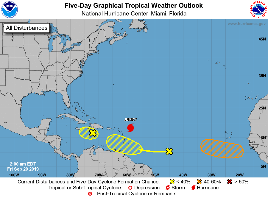
As for the Gulf, while we are watching two disturbances in the Caribbean, neither is expected to develop appreciably as they come west. We don’t see any serious Gulf concerns into early next week. I think we would all feel a little better if we could drive that first cold front through here, so we will be watching closely for any sign of that in modeling heading into next week.
Please don’t use the comments to debate our very real and very present climate emergency. The science is settled. SCW will be removing climate change denialist comments as off-topic.
(SCW is also uninterested in being a platform for a semantic debate about the nature of the word “settled.” Persons interested in having that debate are welcome to do so somewhere else. One potential place where you can argue to your heart’s content is this reddit thread on /r/science, where actual climate scientists are answering questions from the public.)
During one of the insane downpours, My 11 year old grandson texted me from school scared. The lights kept flickering on and off and the sixth graders panicked. When I picked the seven-year-old up he said they had evacuated his class because water came in the room. He was so animated took him close to an hour to calm down he repeated his story over and over. Our kids are damaged by these events and we are helpless to alleviate their fears. I love Houston but I’m to the point now to where I’m considering moving the entire family to a more weather friendly City
Where are mom and dad?
Tom, what business is it of yours?
Working
Houston is looking like it will suffer horribly from climate change – indeed it’s already started. Look no further than the carnage of the past 2 days – yet another 1000 year storm – and our soaring insurance premiums for a small taste of what’s to come.
You sound like a great guy.
As always Lanza. You are totally on top of the weather
As always Lanza . You are on top of the weather.
My man!
Thank you Lee. We are here for the weather and general support. Love SCW’s work.
Great reporting as normal. Do you think that in retrospect we might have crossed into flood stage 4?
I think Eric and I will discuss that. Overall it was a stage 4, for sure, if not a 5 due to Liberty/Chambers, Winnie, Beaumont. But in Houston? This may end up still being a 3. We’ll see. Either way, it was bad.
Mac, for Winnie/Fannet and Bmt I think this goes past flood stage 4, and tops the scale just like Harvey did 2 years ago…
Should we just assume events like this are going to be worse, due to warmer sea & land temperatures (i.e. climate change)?
Seems like models are based on past conditions, and therefore don’t take into account the current trend. Or do they?
Sadly, a handful of models actually did nail max totals here. Like Harvey, they did tend to undersell it a little bit until the last minute. But the signal was there. The lesson for me in all this is that when you see, what I would I refer to as “next level” rainfall totals show up in modeling, you need to assume that someone will verify close to or in excess of those totals. We saw it with Harvey, Florence in the Carolinas, Louisiana in 2016, and now this, among other events. So they actually do have a bit of a handle on this sort of thing, whether it’s a new normal or whatever is happening with respect to climate change. But they have shortcomings too. But in general, they guide us well and they deserve some degree of respect.
What if…some day…the fronts never come? 😐
Tim you better take that back…
Winter isn’t coming.
Shut your devil mouth!
Every year in SE Texas a flooding event (at the very least one). Bet the farm on it.
Matt, Eric, thanks again for your reporting. One thing that I heard yesterday a couple of times was that the rains should slow because the atmosphere was “worked over”, what does that mean?
Big storms need warm moist air at the surface and cool dry air aloft. As the warm air rises the moisture condenses out as rain. Eventually these differing air temperatures equalize and the storms fade away. Ever notice the really cool air right after an intense thunderstorm?
Worked over means that the temperature gradient is not enough to support rising air.
Any idea on the best way to get back to Houston from Lake Charles with I-10 down in so many places? Thanks for all the amazing reporting during all these awful storms!
Watch Google maps with “traffic” option turned on. As of 9 a.m. Fri, it shows I-10 closed westbound at Orange and closed in both directions between Beaumont and the Trinity River bridge. Also, Highway 73 is closed between Port Arthur and Winnie and Hwy 105 is closed west of Beaumont. Things may improve later today if you keep checking the maps. Until then, you may want to sit tight.
Probably Highway 90.
A rough couple of days… please remember to try to help those that are in need.
Thanks to Matt and Eric for the river updates.
Any factual evidence to the rain totals for the area reporting ~40 inches around Winnie?
There were at least 3 40″ totals reported by Jefferson County Drainage District gauges, so it’s about as official as it can be.
Thanks.
Before Imelda moved in earlier this week, I saw rainfall forecast estimates (think it was the Euro model) that showed an estimated 40+ inches in spots near Galveston Bay. I couldn’t believe it. Unfortunately, it nailed it, only off by about 30 miles.
I sincerely hope this isn’t the “new normal” in this part of the world.
And the weather forecasters kind of brushed that off as “not really gonna happen” probably because if they made a deal out of it, and it didn’t happen, they would get the “fear mongering” moniker that so many commentors like to call them.
@ Eric .Your interview this morning in NPR is very interesting and insightful . I always start my day with reading space city weather news and it was very exciting to hear your voice on the radio. Thank you and @Matt for all you contribute to the community.
I’m bound and determined to someday leave this swamp city and never look back. Headed to dryer climate. Four out of the last five years we’ve had a (general category) “major rain event”.
Lets only have Front News from now on.
Some news reports stated Imelda “turned around and came back”. Did that really happen? I was under the impression that the center of circulation for the low pressure area that Imelda became kept going northward, and the rains yesterday just developed around that low.
I am certainly no weather expert, but my hubby is a little bit of a science geek, and as he was watching the radar he kept describing this “back building” where the storm would develop a little in a couple of different spots and then those would join up and become one very nasty cell. It was quite an interesting storm.
Backbuilding, indeed! That’s also what we often refer to as “training.” Just a bad setup yesterday.
No, it kept moving north…just slowly. I’m curious to see if Imelda was the primary cause, actually. I saw from a meteorologist on Twitter a hypothesis that Hurricane Lorena actually played an outsize role in this event from the Pacific: https://twitter.com/wxmanted/status/1175049404279115776
Here is a paper describing what may have taken place:
https://journals.ametsoc.org/doi/pdf/10.1175/2010MWR3243.1
You’ve earned my utmost respect by pulling out a Bosart paper. PREs are fascinating. I got comfortable with them when I worked in the Northeast. But they’re an interesting concept here, and I think this merits a close look.
It’s great that everything is back to normal! I’m glad to see everyone posting again. Still no Armando or Dear Fulgencio update this storm. I guess our two favorites are gone for good.
Should I read between lines on the tropic update? No serious concerns for the gulf into early next week…meaning there are concerns late next week? NHC is indicating westward movement..with development, isn’t that a concern? Or, can we expect these three tropical concerns to shift directions?
Hi Arianda: No, no. I don’t expect development over the next 7-10 days. There is a system coming into the Gulf, but it looks pretty beat up and disorganized, so I don’t believe it has much chance of developing. That said, I am watching to make sure it isn’t going to boost rain chances too far. I don’t believe that it will, but it’s something we’ll be keeping tabs on juuuuust to make sure.
Thank you for clarifying Matt! I’m sure you guess some of us are on edge. And sometimes we might read into things….glad I misunderstand the intent of messaging!
I absolutely understand how on edge everyone is. I’m right there with y’all, believe me.
Imelda was pretty ‘beat up’ too until the last minute. Only a 10-20% chance of development from the NHC and then they had to play catch up.
Every hurricane starts from a disorganized cloud mass. Even Harvey, at first, was thought to become only a TS. Things can change quickly.
Yes, this is true. But there is not much corroborating evidence that there’s any “there” there with these. If we worry over every single disorganized cloud mass during hurricane season, then we will completely wear ourselves out. Need to pick our battles this time of year. Thankfully, not much has changed in 24 hours with respect to forecasts of these waves/disturbances so…good. We’re always watching these things closely, but we try not to overthink them either.
Thank you Matt!
Do you think it’s still too early to plan an outside sweet 16 for next Saturday after all of this?
Unfortunately I don’t have a rain gauge, but we’re getting some good rain here today in El Jardin, Seabrook area. Good steady rain but hummingbirds are still fighting over the feeder.