To begin with, I’ll be honest and say I don’t place much stock in hurricane season forecasts. For one, they’re not particularly accurate (although they do demonstrate some skill). Secondly, although it may be a slow hurricane season overall, if the one big storm that develops hits your community it sure wasn’t a slow hurricane season for you. With that being said there are three main factors we can look at now to get some sense of what is coming beginning on June 1 with the Atlantic season.
SEA SURFACE TEMPERATURES
Simply put, when all other things are equal, warm water provides more fuel for hurricanes. At their most basic level hurricanes are essentially heat exchangers, bringing heat from the tropics into the northern latitudes. More heat in the tropics means more potential energy for these storms.
In the chart below the European forecast model is predicting the sea surface temperature anomaly for the period of July through September, the most critical months for hurricane formation and the state of Texas.
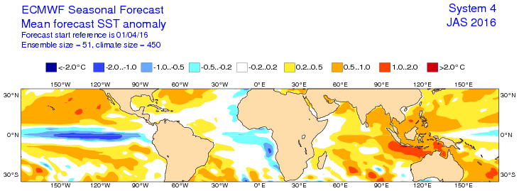
If you look between the United States and Africa you’ll see mostly white, which indicates near normal sea surface temperatures are being forecast where hurricanes most commonly develop. From the standpoint of desiring a slow season, that is certainly better than warm temperatures. Note, however, that temperatures closer to the United States, including in the Gulf of Mexico, are forecast to be warmer than normal. That doesn’t bode quite as well for storms forming close to land.
SEA LEVEL PRESSURES
Hurricanes will not form where there is high pressure, because this sinking air prevents the warm, moist air at the surface of the Earth from rising. So what we really want to see are high pressures throughout the Atlantic tropics, which stretch from the west coast of Africa into the Gulf of Mexico.
Lo and behold, in the European forecast model that’s just what we see for the peak of hurricane season:
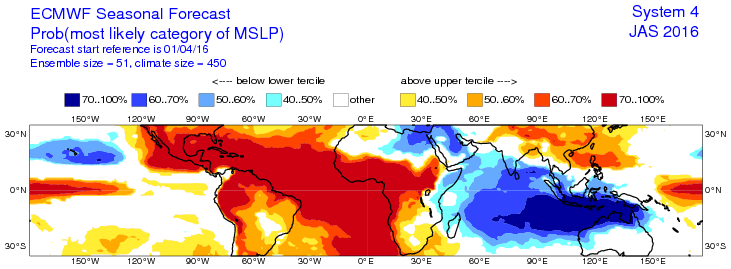
The model is predicting a 70 to 100 percent chance of sea level pressures above normal for the entire Atlantic tropics during the period of July through September. This does not mean pressures will remain high across the tropics for this entire time period, but it would mean that there will be fewer chances for tropical storms and hurricanes to form. If this model forecast verifies it would be fantastic for keeping seasonal activity below normal.
ENSO
A third important factor is El Niño, La Niña, or neutral conditions in the tropical Pacific Ocean. After a very strong El Niño in late 2015 and early 2016, that pattern is now weakening as we head toward summer. The current forecast calls for an increasing chance of La Niña conditions for the second half of this year, which would obviously include the bulk of the Atlantic season.
Typically a La Niña year brings weaker upper level winds over the tropical Atlantic, which in turn leads to lower wind shear over the Atlantic basin. This would favor the formation and strengthening of Atlantic hurricanes.
Moreover, in many years when we’ve transitioned from a winter El Niño to a summertime La Niña there has been more development of storms in the western half of the Atlantic basin, including the Gulf of Mexico. Thus we can expect chances for a hurricane or two in the Gulf of Mexico to be a little higher than normal.
CONCLUSION
Add it all up and what do you get? Sea surface temperatures seem like a wash in terms of overall activity, sea level pressures indicate low activity, and La Niña points toward more activity. For me this points to an Atlantic season with near-normal storm activity. That is consistent with forecasts from Phil Klotzbach at Colorado State University (see .pdf), Tropical Storm Risk (see .pdf), Joe Bastardi of Weather Bell (see forecast), and others.
During the run-up to hurricane season, and lots of talk about storms, it is worth remembering that in most years Houston will not see much tropical activity. On average the Houston region is affected by a powerful hurricane with damaging consequences about once every 20 years. More frequently, perhaps every five years or so, we will see the effects of heavy rain from a tropical storm. This should not preclude you from taking sensible precautions, such as knowing whether you live in an evacuation zone, having of plan for where you will go in the event an evacuation is necessary, and a plan for your pets and important documents and possessions.
Space City Weather will of course have full coverage of any threats to Texas during hurricane season.
Posted at 10:00am CT Wednesday
I like Bastardi’s combined scaling for hurricanes. There’s more to a hurricane than just wind, and combining pressure and wind gives a good idea of what kind of damage a particular hurricane could do/did. Any chance of using both the S-S scale and the Bastardi scale when reporting on future TD/TS/hurricanes?
Unfortunately I’d say there’s almost no chance. For public consumption products need to be simple. Even separating storm surge from the Saffir Simpson scale was a huge deal.
Again…timely and easy to understand info…well done guys…thanks!
Pretty good rundown
Very much appreciate the insight. You make it very easy to understand for those of us that aren’t in science fields. This is one of the main reasons I follow this blog on a regular basis. Keep up the good work.
Thanks for a thoughtful and comprehensive overview of the known significant factors for hurricane formation. I’m loving the blog so far, keep it up!