Good morning. A rollicking night across a healthy chunk of the Houston metro area continues this morning, as now-Tropical Storm Nicholas slowly, but steadily, passes through. As of 4:45 AM, Centerpoint’s website reports over 380,000 customers without power. Wind gusts of 45 to 55 mph are still occurring across southern and some eastern parts of the metro area, with gusts generally in the 30s to the north. The maps here shows the maximum wind gusts we’ve seen at various sites across the area since midnight.
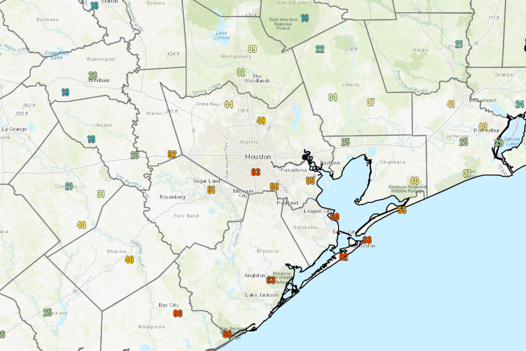
You can see a list of highest reported wind gusts for the entirety of the storm (as of 5 A.M.) here. Judging by radar at 4:55 AM, Nicholas’s center was just getting ready to exit Brazoria County, just north of Rosharon. The center should pass very near or right over Houston a little later this morning. Maximum sustained winds were still reported to be 70 mph at the 4 A.M. National Hurricane Center advisory, though it’s likely to have weakened a bit further by now.
Wind impacts
As Nicholas continues to move north, you can expect gusty winds to travel north and east with the storm. Continued wind gusts of 45 to 55 mph are likely in the city of Houston and points south and east for another couple hours, with a general trend toward lessening wind overall. Areas north of Houston will likely see 35 to 45 mph gusts continue as well through the morning. This could continue to sporadically knock out power to folks across the area. If you have power, it would be a good idea to keep your phone charged, just in case you lose power. As winds subside a bit this afternoon, power crews should be able to get out to begin to repair damage. Power restoration may take somewhat longer where damage is more significant, namely along the coast and southeast of Houston. It would be a good idea to check in on anyone vulnerable, especially the elderly today, just to make sure they have what they need in case they’ve lost power.
Rainfall/Flooding
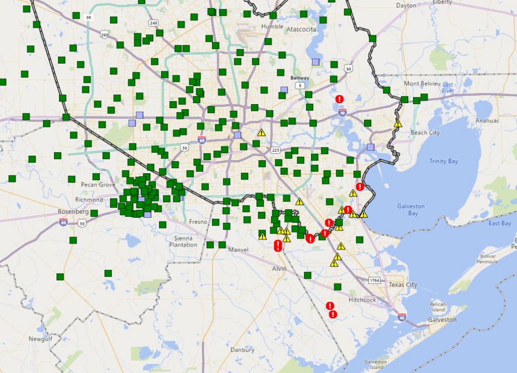
The good news in Houston is that serious flooding has not materialized in the city. The story is a bit different south and east of the city, however. The Harris County Flood Control maps of gauge status as of 5 A.M. shows several locations that are either flooding or close to flooding in far eastern Harris County and along Clear Creek or into Galveston and Brazoria Counties.
Some of the flooding south and east of Houston is coming as a result of surge on Galveston Bay. With the center of the storm over inland Brazoria County, winds have piled up water on the west side of the bay, leading to a generally 2 to 5 foot surge in many areas, highest along the bayshore in Harris or Galveston Counties.
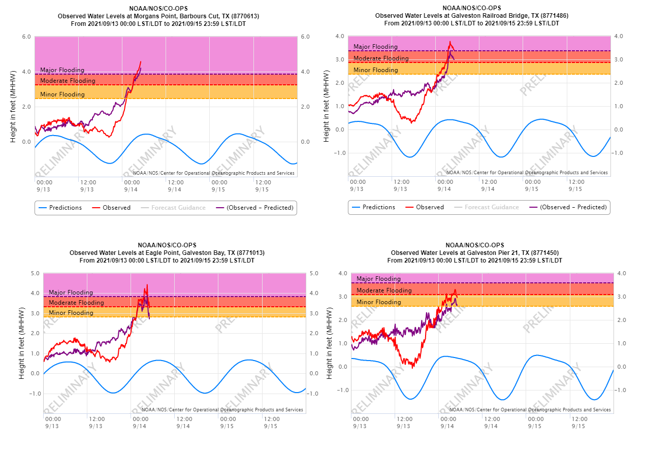
Clear Lake even is close to a 6 foot surge. Expect these values to peak soon, with gradual improvement through the morning and into the afternoon.
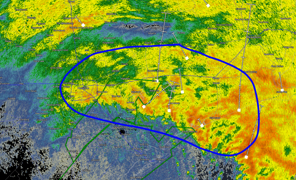
Rainfall continues heavy at times, mainly in Houston and points east now. The circled area below is seeing rates at times over 1 inch per hour. This will be enough to cause some flash flooding, especially as you get into southeast Harris County, Chambers County, and Jefferson County.
While these rates are a little less than we feared, we will still see travel issues in spots east of the city, as well as south of the city as water continues to flow through the system. These conditions should improve a good bit by later this morning and especially this afternoon. The lopsided nature of this storm means that although the center may only just be on the east side of Houston by midday, the main impacts should be mostly out of our area by then.
Heavy rain and flooding risk will continue through the morning across Beaumont, Port Arthur, and into western Louisiana.
Later today and tonight
Though we expect the overall picture to greatly improve this afternoon, at least a few areas may see daytime heating lead to additional showers and storms popping up. Any of those would be capable of producing heavy rainfall, but they will be scattered and likely not widespread. We should see dry conditions tonight. High temperatures today will peak in the 70s, but if we do see any breaks in the clouds west of Houston, we could sneak into the 80s in a few spots. Certainly not terrible, but something to keep in mind if you are still without power this afternoon.
Eric will have our next update around 10 A.M.
Thank you for all you do Eric and Matt. You are a Houston treasure. Someday, can you do a video blog of what it’s like for both of you during a storm? My husband and I were imagining you both (socially distanced?) holed up with a pack of Twizzlers and coffee just pouring over the data. Would be super interesting to read/see a post/video about the behind the scenes 🙂
What does social distancing have to do with this?
She appears to be referring to the ongoing plague mitigation efforts.
They’re definitely socially distanced during the process, since they (along with Maria and I!) do all the SCW forecasting from home 😀
I just looked at the abc news radar and it looks like the storm is moving away from the clear lake area, but the worst part of the storm is circling back up – is it going to circle back around and hit clear lake again?
Your comment reminds me of Imelda and how she circled
Best, most informative, straightforward, telling and all-around weather report I have ever heard. I love that I did not have to click on multiple websites just to get the answers to my questions. Thank you so much. I’m so glad I discovered this website and thanks for your truthful straightforward report!
Thanks for the great work all night. This reminded me a bit of Ike — a storm that passed overhead and didn’t drop a ton of rain but brought a lot of wind and electric outages. Of course, Ike was a lot bigger, higher winds for longer duration. But the Harris County gauge near my house shows only about 3.25 inches of rain over the past 24 hours and half of that came yesterday.
I have followed Eric for several years and I am continuously grateful for what he does. I live in the DFW area, my heart is always in Houston.
Made it through in Cypress relatively unscathed. Had the lights flicker off and on a couple of times, but the power stayed on.
Looks like the rain and wind have subsided though.
Hope those in the direct path of the storms can recover sooner rather than later.
Not much wind near Ellington for the last two hours plus. Peak of storm was just after 4AM. Total rain from event – 7.1 inches.
Big thanks to the Centerpoint people for getting our power back on here in Mo City by the morning. Can’t be much fun dealing with power issues during a Tropical storm at night
In the Westchase area, there are limbs down but fortunately the power is still on. Thank you for your calm guidance all the way through the storm – it helped!
Is this some sort of terrible performance art?
So, Eric/Matt…from the scenarios presented over the weekend, I’m guessing this was “coast hugger”? I mean, it was a challenge for everyone to figure out track (even at 10 p.m. Monday night).
no juice of electrical type here. not much rain but hefty winds all night. could have been worse here, and has in the past!
You guys are so AWESOME and provid such an invaluable service. Thank you!