During the last couple of days there’s been a fair amount of hype about the potential for a tropical depression, or storm, to develop in the Gulf of Mexico. As of this afternoon the National Hurricane Center predicts there is a 60 percent chance an area of low pressure near the Yucatan Peninsula does just that.
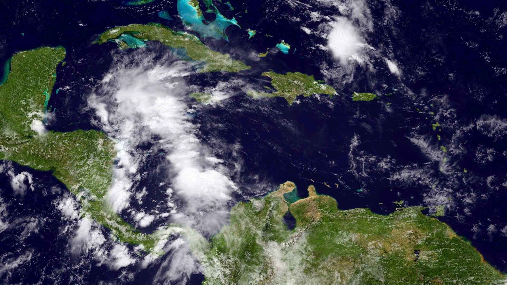
We have not focused on this system for two simple reasons. First of all, Houston has been dealing with its own super soaker for the last several days, quite apart from this tropical system. Secondly, regardless of whether it develops, this mess is moving toward Florida and will have little to no effect on Texas weather.
Overall I don’t see this system developing much, conditions just aren’t that favorable over the next few days. So there’s almost no chance it will present a major wind threat to Florida. However it could definitely be a rainmaker for the Sunshine State, perhaps on Monday and Tuesday of next week, bringing 5 to 7 inches of rain to some areas.
Of course parts of Houston have seen quite a bit more than that during the last couple of days, as heavy storms have moved through Texas in waves. But as Matt wrote this morning, I think we’re past the worst of it, even though very heavy thunderstorms will continue to plague parts of the Houston region today and Saturday. Accordingly a flash flood watch remains in effect through 7pm Saturday and we’ll of course keep you informed about any developing threats.
Posted by Eric Berger at 1:30pm CT on Friday
And this is why we’re paying you the big bucks, Eric! 😉
Thanks.
Will this potential tropical storm affect the speed at which our own rainmaker gets out of our area/goes away?
Maybe tangentially, but it it’s going away on Sunday regardless.
Hey Eric…How does it look tomorrow for Jimmy Buffett
Am thinking at least some light rain is possible, maybe more. But I also wouldn’t rule out decent weather, either.
Okay, I’m a fan, and I know it’s hard to predict the weather in Houston, or Texas for that matter, but with all the models, and all the equipment, and all the science, wouldn’t it be possible to come up with something a little more meaningful? I mean, really? Light rain is possible, maybe more? Can’t rule out decent weather? What’s the difference between that and no forecast at all? Are you just shell shocked by all this rain?
Here’s one challenge, Barry. Let’s say we’re pretty confident there’s going to be rain in the Houston metro area. That’s still an area about 100 miles by 100 miles. Now we might be able to have some confidence that the rains are more likely closer to the coast (south of I-10), or maybe west of Houston (say west of I-45). Beyond that, the processes of thunderstorm development occur on the small scale, often below the threshold of even high resolution models to accurately capture. And finally, let’s say it rains heavily over a neighborhood 3 miles from you, but not your house. From your perspective our forecast busted.
Another factor is imperfect information. Thunderstorms can’t develop if there’s a capping inversion — warmer air aloft. But we don’t have any really good way to know whether this cap actually breaks (we don’t have that data). So we don’t know if the cap breaks until we actually see thunderstorms develop.
Hopefully this helps.
Is it time for Katy to evacuate?
I’m glad I was able to see some sun and blue skies in Katy today!