Autumn. August. Both are basically the same, right? We hit 98 degrees officially in Houston yesterday, our hottest late September day since 2005. We have a shot at meeting or exceeding that level again today and maybe again on Monday before we can hopefully be done with this level of ridiculous heat.
Meanwhile, Invest 98L became Tropical Depression 9 in the Caribbean overnight. It should not impact Texas, but it will likely be an issue for Florida or the eastern Gulf. More on that below.
Today
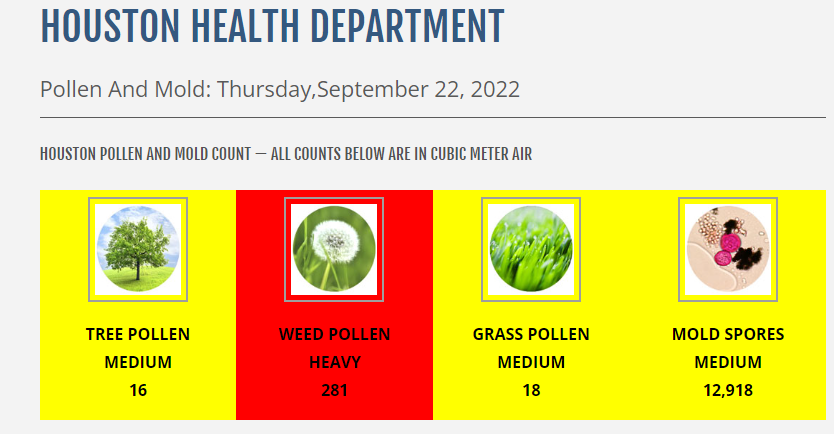
More of the same. Highs likely just shy of 100 with sunshine. Watch for poor air quality (high ozone), in addition to high levels of <ah choo!> ragweed.
Weekend
Temperatures may crawl back a couple degrees this weekend, but that’s because humidity levels may increase just a bit. All else equal, it will continue to feel more like summer than fall: Mid-90s by day, mid-70s by night. A shower can’t be entirely ruled out, especially Sunday, but you’d be lucky if you saw one.
Monday
This may be the trickiest day of the forecast. We are expecting a cold front to descend on southeast Texas on Monday. Air masses tend to be at their hottest immediately before a front passes through. In addition, this front will come with little moisture and minimal rain chances. With humidity likely falling through the day on Monday, we will have a much easier time heating up, assuming sunshine. I would not be shocked to see some places blow past 98 or 99 degrees Monday afternoon.
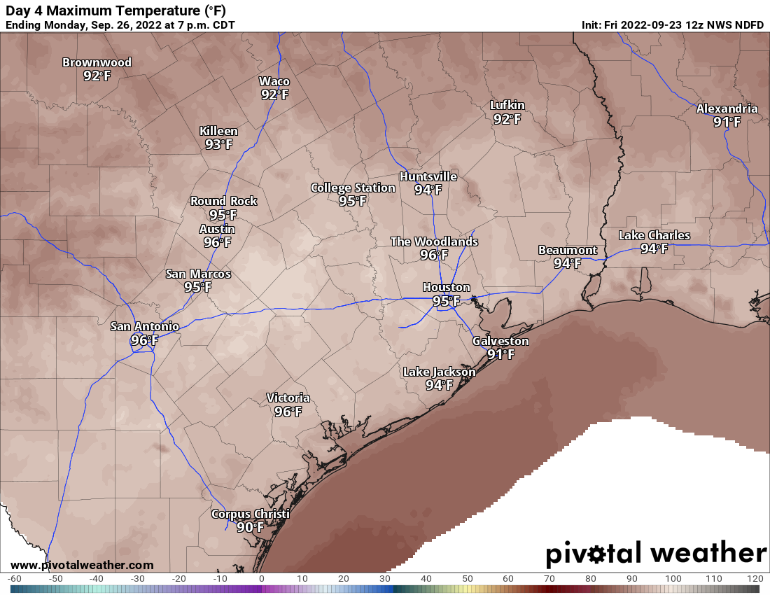
Current forecast highs are hot, but I think there’s some chance we end up beating some of these numbers.
Tuesday & beyond
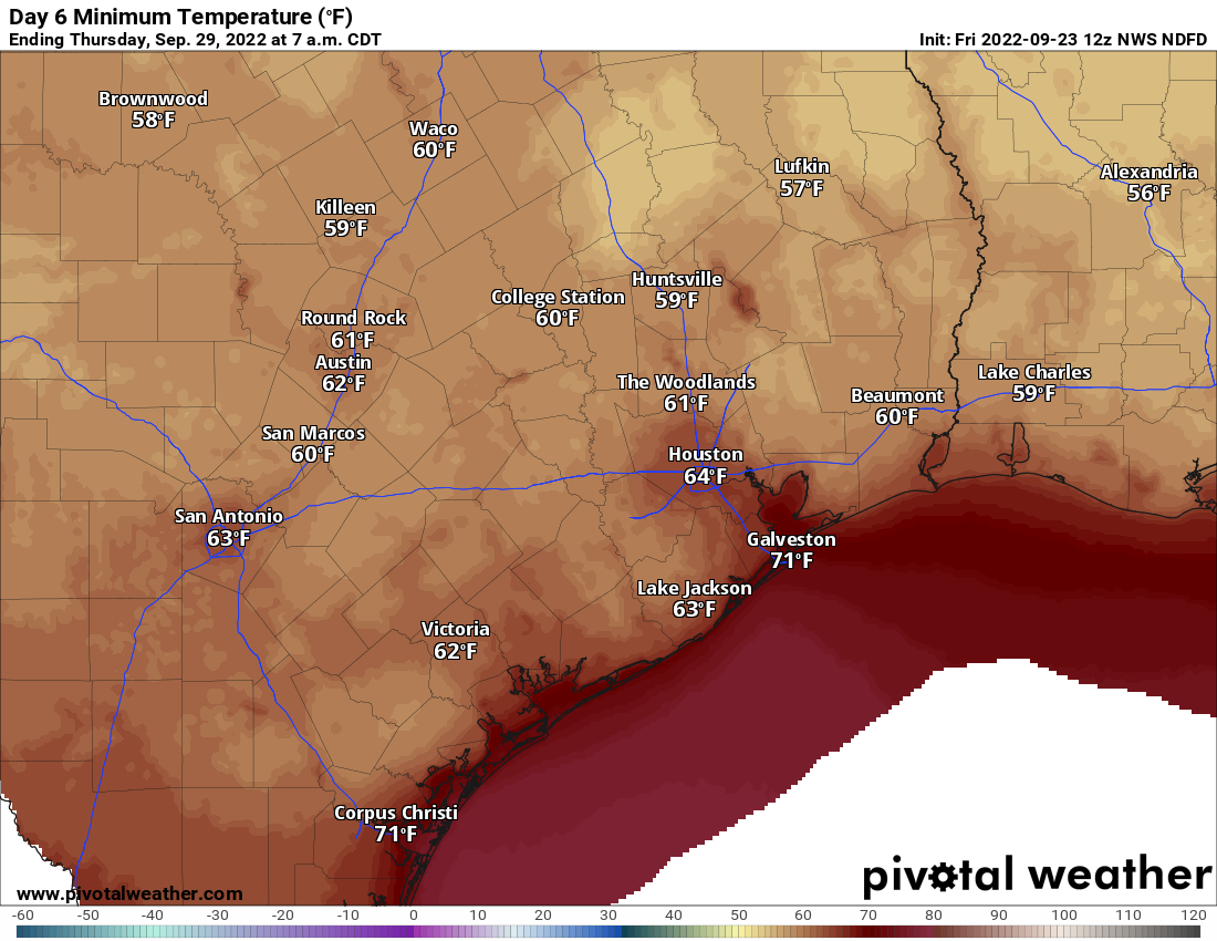
The rest of next week looks nice by September standards in Houston. We should see low humidity, allowing nighttime lows to drop into the mid or lower 60s away from the Gulf and bays. Inland locations even have a shot at 50s!
Daytimes will remain fairly hot, but not nearly to the levels we’ve seen lately and with much more tolerable humidity. In other words, the shade and a breeze should offer to provide sweet relief from heat. Look for upper-80s to 90 or so each day. Rain chances seem close to zero all of next week.
Tropics
So now we’ll discuss the tropics. Again, we do not expect that Tropical Depression 9 will impact Houston or Texas at all. So what will it do?
This morning, TD9 is located just off the coast of Venezuela. It finally pushed away from land and more out into the water yesterday, which has allowed it to organize.
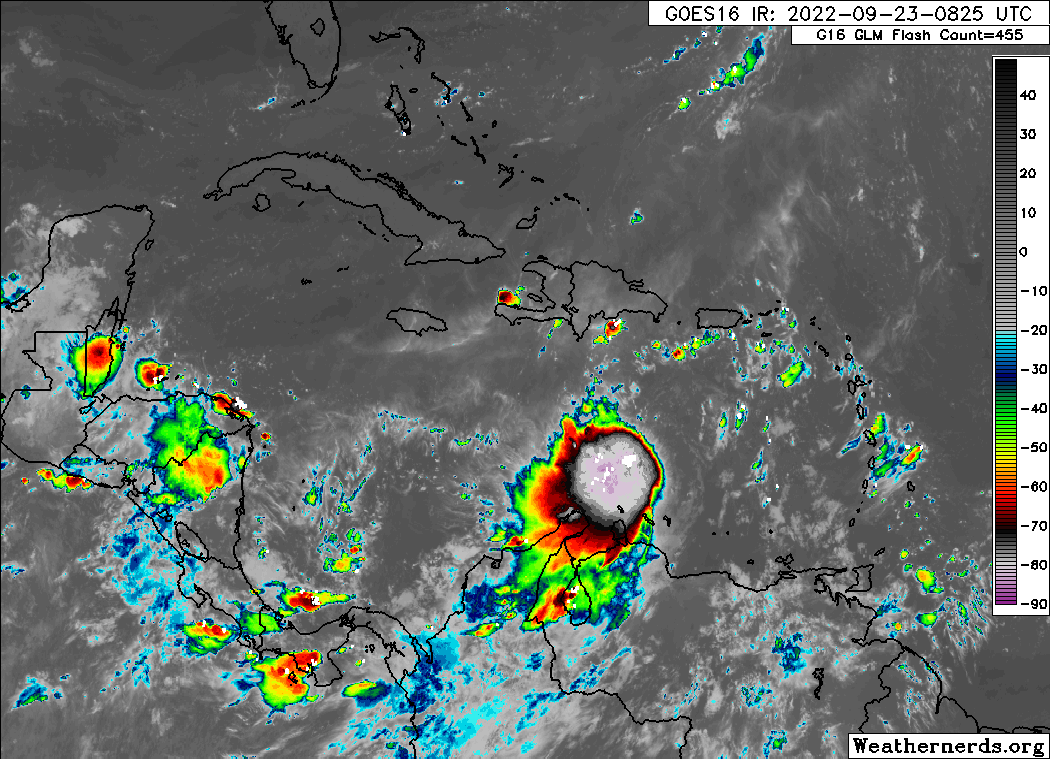
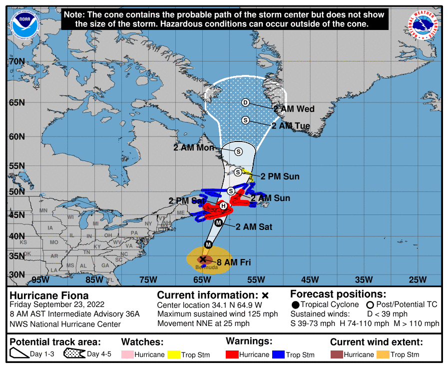
Granted, it doesn’t look great on the satellite image above. There is still a lot of wind shear in the wake of Hurricane Fiona, which is impacting TD9’s growth. It will initially be slow. As TD9 works west, it should emerge from that shear into a more stable environment, and that’s when we may see it intensify more rapidly.
TD9 is expected to work just north of west over the next couple days, but it will eventually likely feel the impacts of our cold front and resultant trough over the Eastern U.S. by early next week. This will allow the storm to turn northwest and eventually north and probably northeast as well in time. Thus, the track forecast for Nine shows it threatening Florida in time.
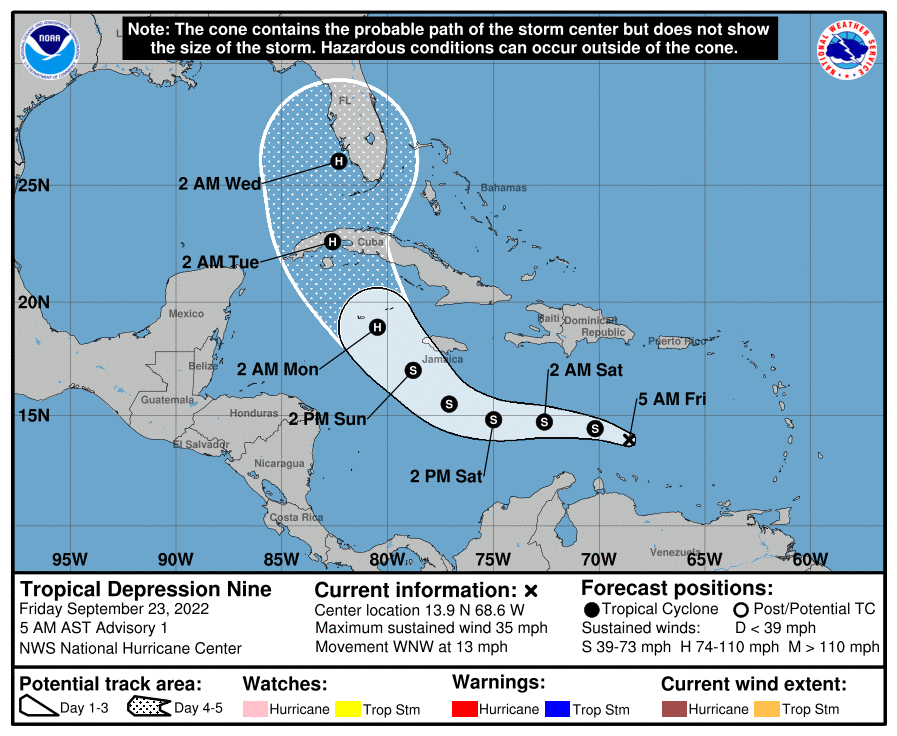
Given the geography of Florida and the Caribbean and the turn expected from TD9, there are many, many questions on intensity and impacts. If the turn happens earlier than forecast, that could lead to more land interaction with Jamaica and Cuba’s eastern mountains, which could keep the system a bit disheveled and also allow it to track east of Florida. If the turn is slower, this could give TD9 more time over the Caribbean rocket fuel (mostly normal for this time of year), allow it to strengthen more, and produce less hostile land interaction. Thus it would be a bigger threat to the Florida Peninsula. If the turn is much slower than forecast, then odds increase for the Panhandle or Mississippi/Alabama coasts. All options are reasonable right now, but consensus favors something near the current NHC track.
Given the general interest in this system, as well as the potential impacts to the planned Artemis I launch in Florida next week, Eric and I will keep you updated on this storm through the weekend.
One last note. We’re obviously watching TD9 closely, but Fiona is still out there, and it is about to absolutely hammer Atlantic Canada. Much of Nova Scotia, Prince Edward Island, and Newfoundland are under hurricane warnings. Tropical storm conditions are even expected as far north as Labrador. This will likely be a generational storm for Nova Scotia. This area often experiences large storms, but this will be at another level and perhaps worse than Juan in 2003.
Thoughts with our Canadian friends through a pretty trying event.

Nothing allows me a sigh of relief like you guys saying “not coming here” especially in September! Thank you so much for doing what you do in the way that you do it. Your professionalism is unmatched!
Many people I know and love live in Nova Scotia..thank you for including Fiona in you update. I always appreciate your coverage of storms and this is no exception.
Indeed. We know what they are in for. It’s very concerning.
Beautiful, beautiful country up there. I hope the impacts somehow end up more minimal than forecast and that it gets through quickly. Well wishes for the folks up there.
Well I have to say we’re back to the bummercasts. I like ‘ridiculous’ heat. I just don’t like it that it never rains…sunny skies next 10 days on top of 2 weeks past. Please discuss that. Does no one think about the farmers. Tropical storms are most welcome here. Really. Chance of bullseye remotely low or you live in a gully.
i agree with this, we need rain here and we have been so dry this year. The desert seems to be moving east! No one is talking about this
Your trolling right? This was discussed throught the summer that areas were in drought conditions this year as well last year it was predicted La Nina would have impact with drier conditions.
I am a farmer/cattleman in Fort Bend and Wharton counties. We actually need dry weather for a while longer now to finish field work and make hay. The wet spell in August and early September put us behind.
Just looked at the GFS run – Tampa is not a good place to bring in a 955 mb (Cat 3) hurricane.
Where’s a good place for a Cat 3?
A major hurricane hasn’t made landfall in Tampa in over 100 years
I also would like to know more about the long range prospects for rainfall through fall and spring. From what i have read, la nina is expected to continue. So does that mean next year will be like this year? No rain to speak of. Extreme summer heat. Much of the yard is dead and i wonder if i should even try replacing grass.
Yes, it’s unfortunately looking like we are settling into a pattern of drier weather for a good chunk of time. I would have discussed that more this AM, but other stuff takes center stage at the moment. If it’s anything like La Niña has been the previous two years, expect long stretches of dryness punctuated by heavier rain for a week or two.
Ok good deal. Y’all certainly warned us well before anyone else what was coming February 14 2021. At least 2 weeks advance warning. So that’s where you shine. I personally don’t care much about tropical systems I don’t have a beach house and don’t live in a gully. And I can see for myself the radar track and forecast position. Just your comment here has pushed me to fire off my big irrigation systems again as everything has dried out from August. Any insights on why eastern pacific tropics are staying cold 3 years running are always welcome and useful. Somebody must be writing a paper. Thanks.
Eastern pacific tropics have been pretty active this year: exactly opposite of normal La Niña.
Matt, do you mean another year of this, or are you just talking about the next few weeks?
Oh, and are you saying there will be ANOTHER year of La Nina? How unusual is this?
Just moved from Houston to Jacksonville and you guys are still my go to for info on the tropics. Wish we had something similar in Jacksonville.
I say that every state in the country, let alone every location in the world should have hype-free forecasts. I’m from Chicago, myself.
Matt and Eric are an incredamazing team, for sure.
Whenever you mention Matt and Eric, mention Maria too. And the support guys behind the team also get credit.
I’ve lived in S. Fl the last 11 years and highly recommend following Denis Philips out of Tampa and Bryan Norcross out of Miami. You can find both of them on Facebook.
where is the rain???
Honestly, if Houston city (and other area municipal) landscapers would start mowing down around it rather than cultivating gorgeous stands of the giant ragweed they don’t recognize as such, September would be a lot less painful.