In brief: After a mostly quiet Tuesday, the potential for widespread showers and thunderstorms will increase tonight and into Wednesday morning. Here’s our latest thinking.
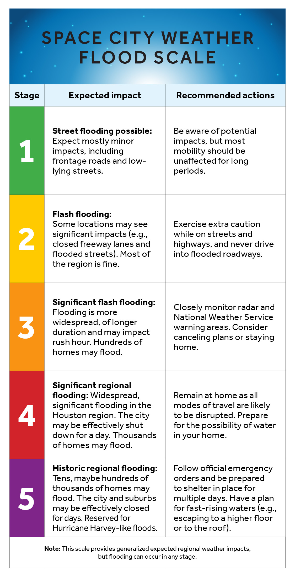
This post will only cover the forecast for Tuesday evening through Wednesday morning. However, in the big picture, not much has changed with our forecast through Memorial Day weekend. We still expect periods of widespread and, at-times heavy rainfall. Our Stage 2 flood scale alert remains in effect through that time.
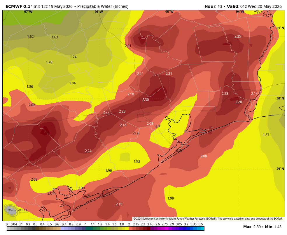
Precipitable water levels will be very high this evening. (Weather Bell)
As for tonight, we still do not have great confidence in the finer details of the forecast. But there are a lot of red flags out there, including an atmosphere that is extremely rich with moisture, an approaching (but dying) front, and a fair amount of instability. This, typically, leads to moderate to heavy rainfall. There’s still a chance this could bust, but I do feel as though the region will see some activity tonight.
As a best guess, I think we’ll see a line of storms, possibly broken, form north of Houston roughly along Highway 105 tonight around midnight, or maybe a bit before. This line of storms should then move southward shortly after midnight. Possibly we could see some damaging winds within the stronger storms, but the bigger threat is heavy rainfall. Whether those storms hold together all the way through the Houston metro area and down to the coast is not entirely clear, but that mess should be moving offshore before sunrise.
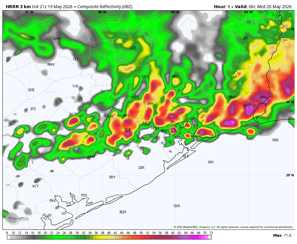
For illustration purposes only: HRRR model forecast for radar reflectivity at 1 am CT Wednesday. (Weather Bell)
Even as it does so, another mass of showers and thunderstorms may advance into Houston from the west. Most of our guidance indicates that the threat of rainfall from these storms will be highest along and south of Interstate 10, so basically areas closer to the coast. These storms could reach Houston around sunrise on Wednesday, give or take a couple of hours, before weakening. Or maybe the atmosphere will already be too worked over for them to have too much impact.
Again, there’s a fair amount of guesswork here, but we wanted you to be aware of the potential for heavy rainfall overnight—amounts will vary broadly, from 0.5 inch to 4 inches (maybe) in isolated areas—and into Wednesday morning.
We’ll be back by 7 am with a full forecast for you.
In brief: In today’s post we’re are initiating a Stage 2 flood alert through Memorial Day Weekend due to the potential for periods of heavy rainfall that will accumulate in creeks and bayous over time. Please remain weather aware for the next week.
Overall pattern
With the complete breakdown of high pressure, plenty of moisture in the atmosphere, and an upper air pattern that will eject a series of disturbances into Texas from the southwest, the next seven days (at least) should feature periods of moderate to heavy rainfall. During this time accumulations of 4 to 8 inches of rainfall are possible, with higher amounts likely in some areas. As rainfall totals stack up over time they may bring some rivers, creeks, bayous, and other waterways to flood stage. For this reason we are putting a Stage 2 flood alert into effect through next Monday. This means that while most of our roads should be fine most of the time, there will be the potential for flash flooding, and you should remain weather aware.
You have questions, we don’t have answers
Let’s start with this fact: The large mass of showers moving into southwest Houston this morning was not well predicted. This underscores the reality that timing these atmospheric disturbances (which produce the lift and other conditions needed for rainfall) more than 24 hours out will be difficult. I know there are a lot of graduations later this week, and weekend, in addition to graduation parties. It is that time of year. Unfortunately there is no way I can sit here on Tuesday morning and tell you whether it will, for sure, rain on Friday evening, Saturday afternoon, or whenever.
All we can really say is that there is a good likelihood of rainfall, some of which may be heavy. Some of these showers may come in the form of thunderstorms, but the overall threat for severe weather beyond rainfall is not particularly high. It also will not rain all day and night, certainly, but the potential for showers during the daytime, through Memorial Day, is pretty high, especially over the weekend.
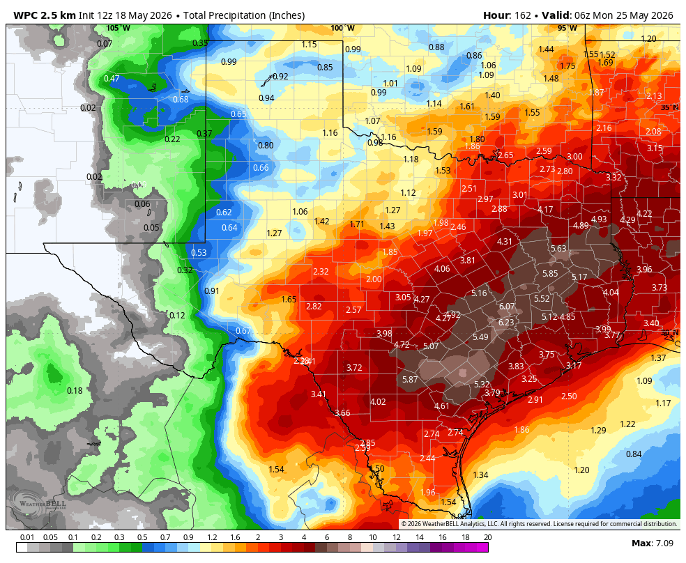
NOAA rain accumulation forecast for now through Memorial Day. (Weather Bell)
There are some benefits to all of this. Although Harris County is now drought free, many areas near Houston remain in a moderate to severe drought. Additionally, you may have heard about the water crisis in Corpus Christi. This will not end the problems there, but the potential for 3 to 6 inches of rainfall over the next week in the Coastal Bend area will provide some help with at least short-term water issues. And finally, instead of high temperatures around 90 degrees, we are going to be in the low- to mid-80s for the rest of the week.
Tuesday
Well, if you read yesterday’s forecast post, you may recall that I thought most of the daytime on Tuesday would be rain-free. Surprise! The arrival of a round of showers from the southwest this morning means that we could see intermittent showers through about noon. I think the stronger storms associated with this system will mostly remain off the coast, but we can’t rule out some moderate or heavy rainfall in the Houston region this morning. After this we probably will see some partly sunny skies this afternoon that will allow high temperatures to push into the mid- or possibly upper-80s. It will be plenty humid.
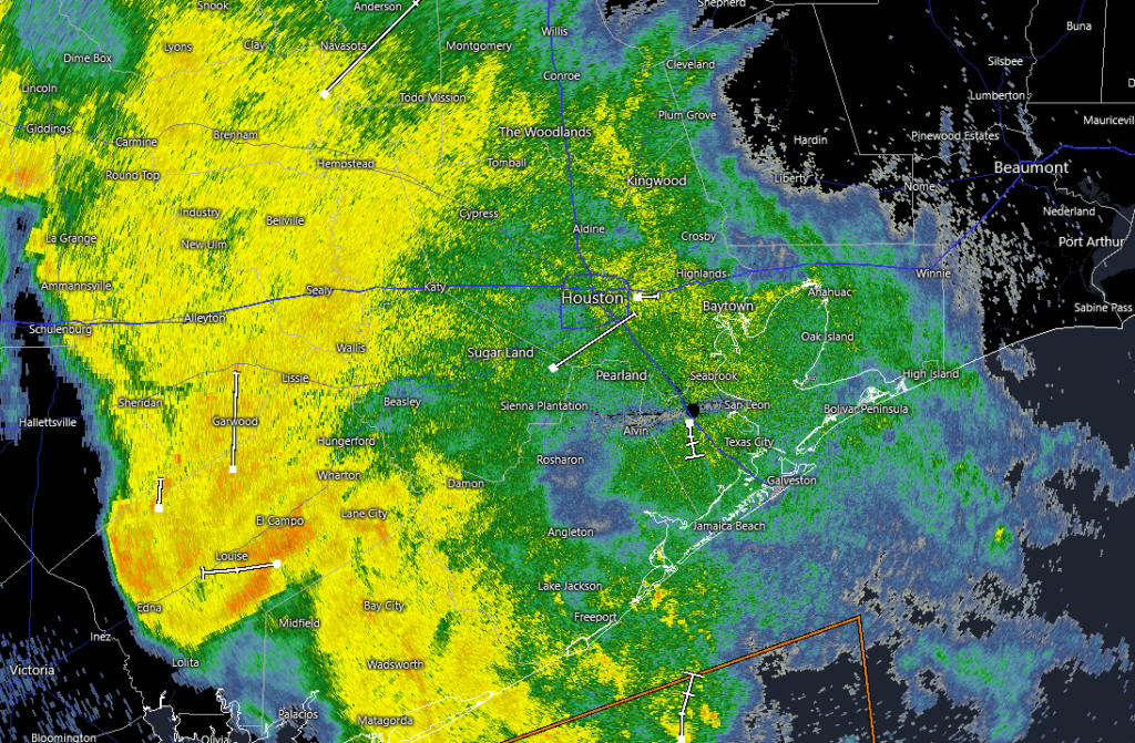
Houston’s radar at 7 am CT Tuesday shows a surprise round of showers advancing from the southwest. (RadarScope)
Then, beginning this evening, a weak front will approach and should move into the area from the north. I am not totally confident in how this system will progress, but we can probably expect a line of storms to develop north of Houston around sunset (i.e. in the vicinity of Conroe), and then propagate south into Houston this evening before reaching the coast around midnight, give or take. I suspect these storms will weaken as the move into the city, you should nonetheless be prepared for the possibility of thunderstorms this evening, and into early Wednesday across the region.
Wednesday
This will be a partly to mostly cloudy day, with highs probably in the mid-80s. Rain chances during the daytime hours will likely depend on how worked over the atmosphere is on Tuesday night (i.e. more widespread storms on Tuesday evening would probably lead to less coverage on Wednesday during the daytime, and a weaker line of storms on Tuesday would allow for more widespread showers and thunderstorms on Wednesday). Anyway, I’d peg rain chances in the vicinity of 50 percent. After today, rain chances will increase for the rest of the week.
Thursday, Friday, and Memorial Day Weekend
In general we expect these days to have mostly cloudy skies, highs in the lower 80s, and overnight lows in the mid-70s. That’s the easy part. In terms of rainfall, each day will have rain chances in the vicinity of 70 to 90 percent, with slightly lower chances during the overnight hours. It would be a fool’s errand to try and predict precisely when it will rain, or when the heaviest rainfall will occur. Just know that the pattern will be broadly supportive of rainfall, and that as amounts accumulate we may well see street flooding and flash flooding (rapidly rising waters). Generally mobility will probably be OK most of the time, but probably not all of the time for everywhere. We, at Space City Weather, will be with you the whole period. It’s not exactly the Memorial Day Weekend festivities we envisioned either, but here we are.
Next week
Rain chances will remain healthy next week, but probably take a step back to around 50 percent daily. Maybe. Honestly, it’s difficult to predict when this overly wet and cooler pattern will end with any confidence.
In brief: After Monday Houston’s weather will turn to a much wetter pattern that is likely to persist for at least a week, if not longer. We are holding off issuing a Stage 1 flood alert for now, but it is something we’re going to be watching closely in the coming days.
Our pattern is a changin’
The atmosphere above Houston will turn unsettled this week in the absence of high pressure, and with a large scale pattern that will send a series of disturbances into the region through the weekend. When you add in a stalled frontal boundary and very high levels of moisture, you get a recipe for rainfall, and potentially lots of it, through the weekend.
NOAA rain outlook for this week, through Sunday, shows 3 to 5 inches of precipitation. (Weather Bell)
Here’s what we know: The overall pattern will support the development of widespread showers beginning later on Tuesday and Tuesday night, and persisting through the coming weekend. Most of the region is likely to pick up between 3 and 5 inches of rainfall, but there are almost certainly will be some bullseyes above 5 inches as rainfall totals stack up. For now we are going to hold off issuing a Stage 1 flood advisory, but that may well be coming in a day or two as rainfall totals begin to stack up later this week.
What about severe weather? A weak front is likely to approach Houston, and possibly push into the area on Tuesday evening or overnight. If this happens it could trigger some stronger thunderstorms, some of which become severe in terms of damaging winds and possibly hail. The timing for this is still uncertain, but potentially it could impact the commute home on Tuesday evening or the later hours.
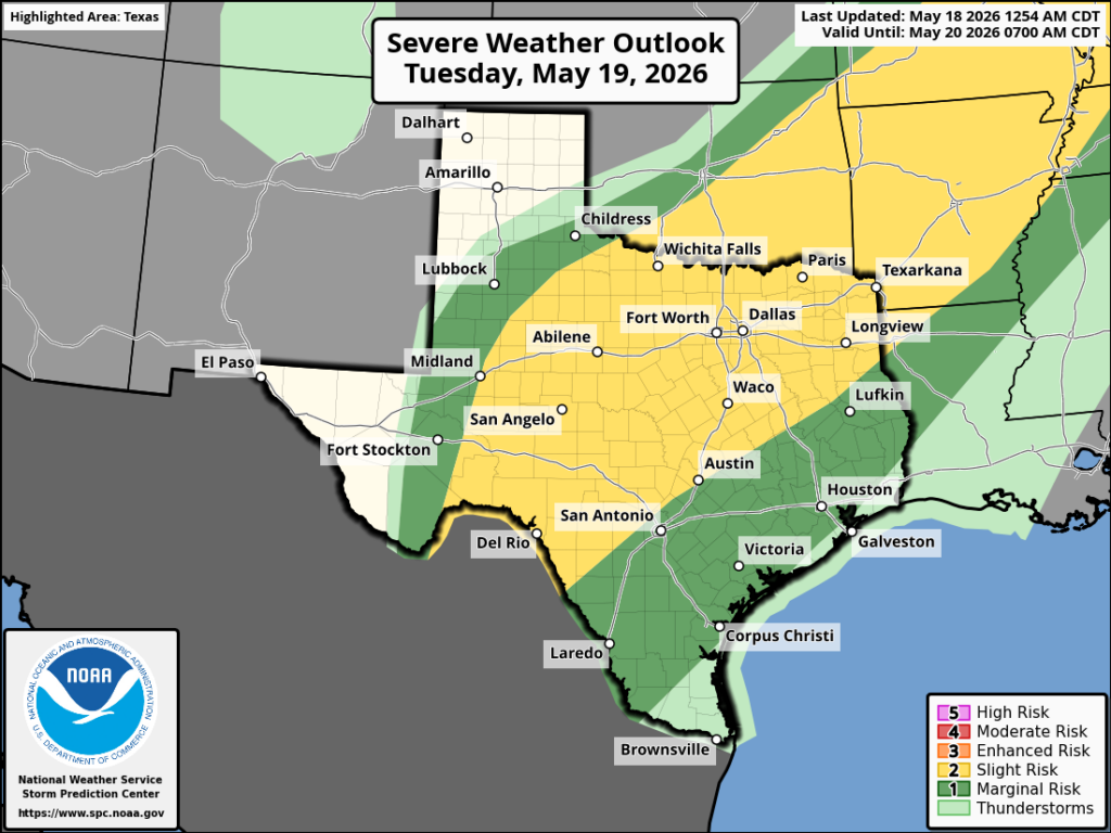
NOAA severe weather outlook for Tuesday and Tuesday night.
This wet pattern is likely to persist through the weekend, and possibly into early next week.
Monday
If you’re wondering when it won’t rain this week, today is a good bet. I think we’ll see some isolated showers today, but overall our skies should mostly be cloudy. Even so temperatures are likely to push into the upper 80s, with plenty of humidity, so it will be a warm one. We are going to see those gusty southerly winds again, especially during the afternoon hours. They will die down overnight, with temperatures only falling into the upper 70s (at most) for much of Houston.
Tuesday
Rain chances should again be pretty low during the daytime on Tuesday, perhaps in the vicinity of 20 percent. We also will have a decent chance at seeing a bit of sunshine during the midday hours, probably our best shot at clear skies for the rest of the week. This will help temperatures once again rise into the upper 80s. The uncertainty will come later in the day when a front approaches the area from the west. This will bring a line of storms with it, but at this time it is not clear that the front will push into the city of Houston, or all the way down to the coast. So while there is a chance of widespread showers and thunderstorms during Tuesday evening or Tuesday night in and around Houston, I am not fully committing to it. Lows on Tuesday night should drop into the mid-70s.
Wednesday, Thursday, and Friday
These will be prime time days for widespread showers and possibly thunderstorms. Daily rain chances, for pretty much the entire area, will be on the order of 80 percent. Skies will be mostly cloudy. Again, for now we’re holding off on flood alerts, but we are going to be closely monitoring rainfall totals and a changing forecast. To be clear, for now we expect things to be mostly fine in terms of driving condition most of the time, but we’re just going to have to see. Highs will be in the low- to mid-80s, with overnight lows in the mid-70s. Mid-may could certainly be hotter, so there’s an upside to the showers.
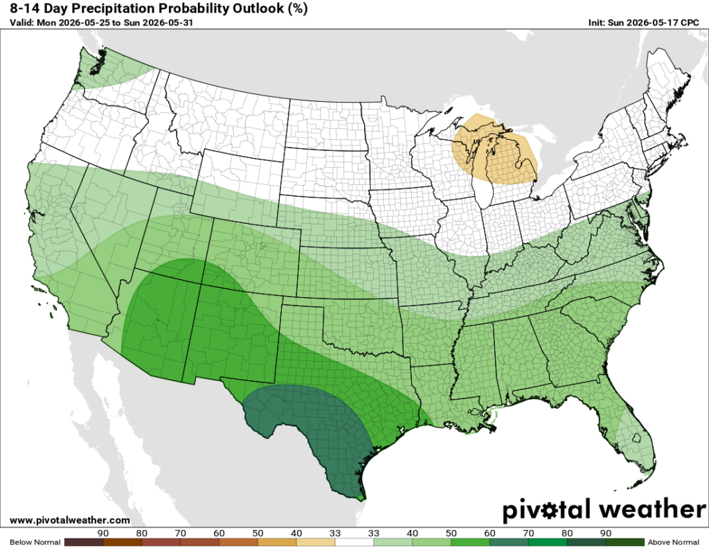
A soggy pattern will persist through next week, most likely. (Pivotal Weather)
Saturday, Sunday, and beyond
This general pattern is going to persist into the weekend. If I squint, it’s possible that we could see daily rain chances come down to something like 60 percent. But I don’t have much confidence in that. Highs will remain in the low- to mid-80s with mostly cloudy skies. At this point the pattern does not look to change too much next week. Rain chances may come down a bit. We may have some partly sunny and slightly warmer days. But overall the possibility of rain remains in the forecast. Happily, it appears that Mother Nature is preparing to wipe all vestiges of drought from our area before we get into summer proper.
In brief: After the hottest day of 2026 in Houston, we expect a quiet, less hot but more humid weekend. Rain chances then pick up next week with potentially locally heavy rainfall in spots by midweek.
Yesterday was our hottest day of the year in Houston, as we officially hit 91 degrees at Bush Airport. Lest anyone wonder if IAH is too overcooked, a CenterPoint sensor adjacent to the airport hit 90 degrees, so the answer is probably not. Hobby Airport also hit 91 degrees. That’s our 5th 90 degree day of the year. Early summer is here.
Today
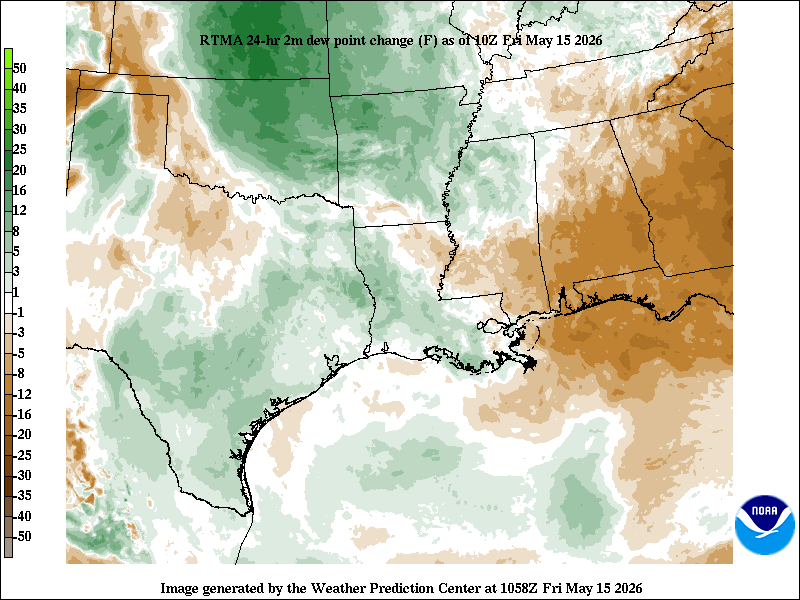
We have a shot at pushing 91 again today, though I think we may come up just a tinge short. Dewpoints and thus humidity are a bit higher today.
Dewpoints have increased a little bit in the last 24 hours, meaning temperatures may not be as hot as yesterday, but it’ll be close. (NOAA)
We also have a few extra clouds streaming through the area today. Either way, we are quibbling. It should feel fairly similar today to yesterday.
Weekend
Saturday looks fine. Sunday could see an isolated shower but nothing that would significantly disrupt your plans. You will notice the breeze this weekend. Onshore winds around 15 to 20 mph with gusts as high as 30 mph are possible on both weekend days as more humid air continues to rush ashore. High temperatures will probably come up short of 90 degrees, with mostly upper-80s expected. Cloud cover will be noticeable on both days, along with breaks of sunshine.
Next week
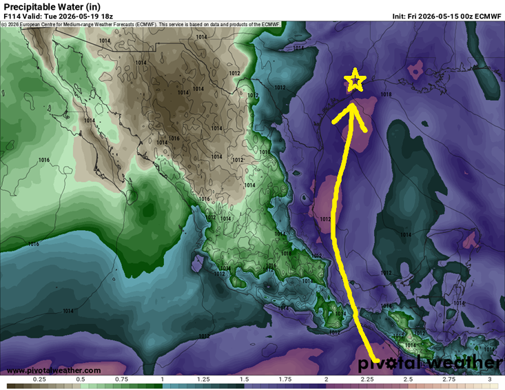
Expect a more active weather week next week. A pretty substantial plume of moisture in the atmosphere is going to extend from Texas, across the western Gulf, and into Central America. Some of this moisture plume actually extends back into the eastern Pacific too. So, we will have plentiful moisture in place to support potentially heavy rainfall in spots.
The moisture will be there next week, but where will the triggering end up? (Pivotal Weather)
The question we can’t answer this far out is where the triggering will end up. Will it be mainly in interior Texas? Louisiana? Here in Southeast Texas? We don’t know just yet, but there are plenty of signals in the modeling that 1 to 2 inches of rain or more will fall next week across the region. Isolated higher amounts would be almost guaranteed in this type of pattern. Bottom line: It’s too early to say exactly who will see the most rain next week, but there is an increasing chance that some parts of the area will receive locally heavy rainfall, especially next Tuesday or Wednesday. More to come on this.
The rain will hold back daytime temperatures a good bit, with highs mainly in the 80s but the moisture and clouds will hold lows in the mid to upper-70s. May the foggy glasses when you step out of the car commence.