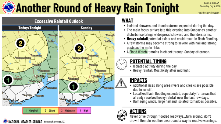
In brief: All our available data continues to point toward the arrival of a line of storms after midnight, moving from west to east across the Houston metro area. Because the heaviest of these rains are likely to fall north of Houston, and the high amounts of rainfall already received there this week, we are raising our flood alert for areas along and north of Interstate 10 to Stage 2 for tonight and Sunday.
The overall pattern we’ve been in for the last several days will persist tonight into Sunday. That is to say, the atmosphere is chock full of moisture and unstable. A forcing agent will come early Sunday as a disturbance moves into the region from the west. In recent days the trend has been toward rain events over-performing expectations. So I don’t want anyone to let their guard down just yet.
After midnight we’re likely to see the development of an MCS to the west of Houston. What is an MCS? In meteorological parlance, it stands for ‘mesoscale convective system,’ essentially a large complex of thunderstorms. But when they come through at night I prefer to think of an MCS as a ‘midnight canine stimulant.’ So yeah, it could be one of those nights.
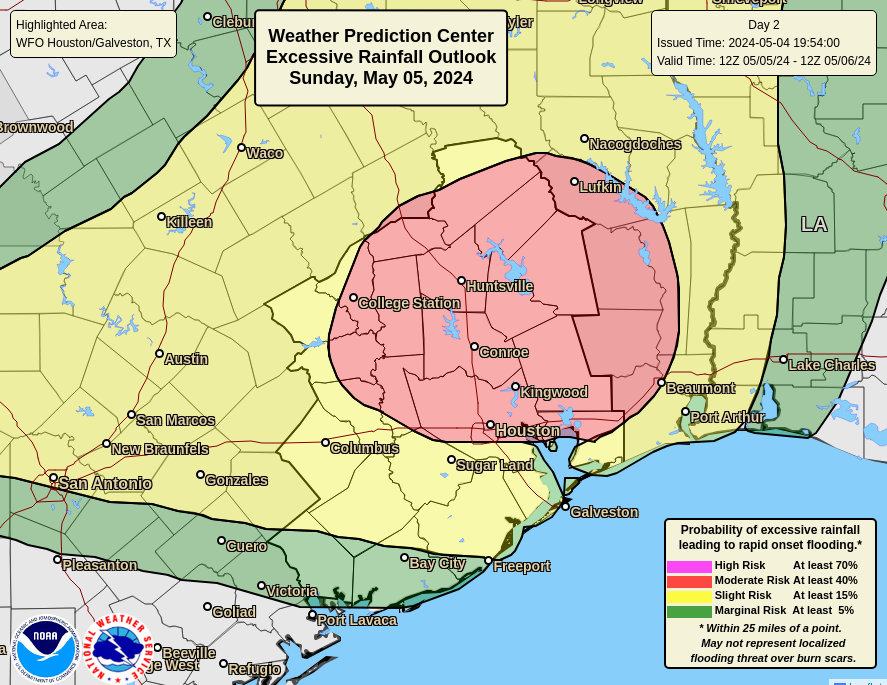
The area at the highest risk of heavy rainfall on Sunday is highlighted in red in the map above. (NOAA)
The primary risk is thunderstorms and heavy rainfall. Generally, I think most of the area will pick up 1 to 3 inches, but my concern is the potential for bullseyes of 5 inches, or more. The most probable location for these heavy rains is areas north of Houston, which have already received a foot of rainfall, or more, during the past week.
After the strongest part of the MCS sweeps through, likely around 3 to 6 am for areas such as Katy, 4 to 7 am for downtown Houston, and a little later for the coast, we are likely to see additional showers—on and off—for most of the rest of Sunday. It’s my hope that these will be a little less intense, and a little less organized than the initial push early on Sunday. Matt will have a full update for you tomorrow morning.
You’re probably not going to be believe me, and that’s fine. But I still do expect our pattern to dry out on Monday. We’ll turn sunnier, and hotter for awhile. Rain chances may not go away entirely, but they’ll be significantly diminished.
In brief: A few showers are possible today, but for the most part Saturday should be an okay day. Another round of storms and potential heavy rain arrives tonight and Sunday which could renew street flooding in spots. Quieter, hotter weather arrives next week.
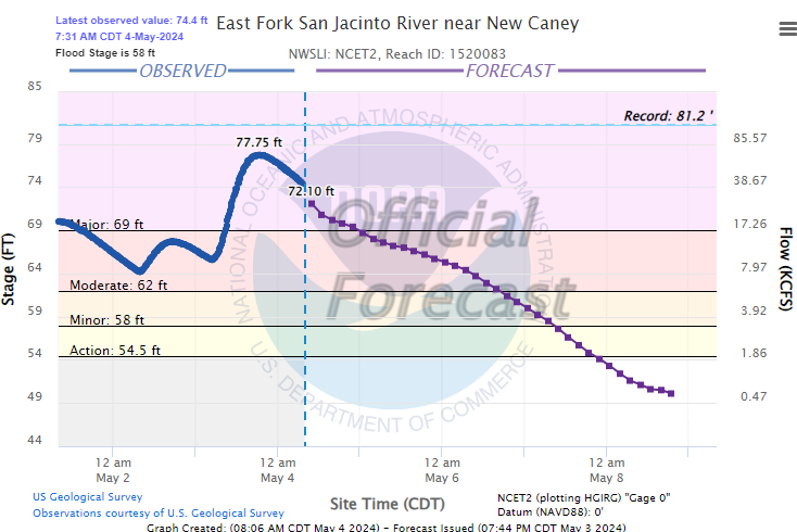
The East Fork of the San Jacinto has crested at New Caney but will only slowly fall.
Flood gauge for the East Fork of the San Jacinto at New Caney shows that the river has crested and should stay in major flood through tomorrow. This does include additional forecast rainfall. (NWS)
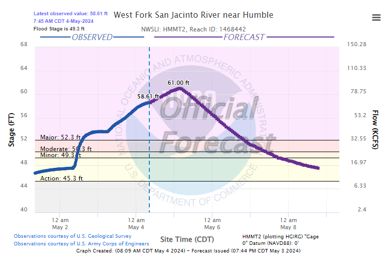
To the south, the West Fork of the San Jacinto at Humble is expected to crest on Sunday and remain in major flood until at least Monday or Tuesday.
The West Fork of the San Jacinto at Humble will probably crest tomorrow. (NWS)
The San Jacinto will continue in major flood downstream as well, with very fast flow passing barges near I-10 which could lead to some loss of mooring.
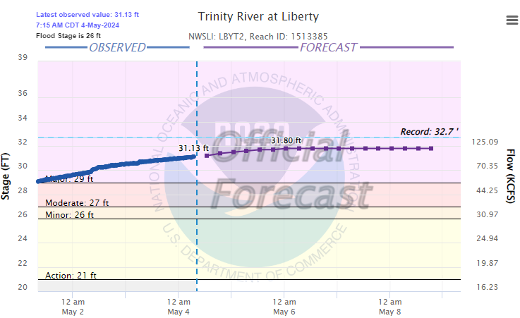
Unfortunately, the Trinity in Liberty County is going to remain just shy of record levels for several days, allowing major flooding to continue.
The Trinity River at Liberty is going to flirt with records into next week. (NWS)
Please continue to heed the advice of local officials and never drive around barricades.
Saturday morning & afternoon
The good news this morning is that radar is vacant around Houston for the first time in some time. There are a few storms passing through the Beaumont-Port Arthur area up toward Jasper, but they’re moving offshore or into Louisiana. I would expect the morning to be fine in most areas.
With daytime heating, scattered showers and a few thunderstorms should begin to develop this afternoon. These will be hit and miss; some people will see downpours, others will be dry. I expect these will move along at a decent pace. The belief is that both the movement and the actual rain rates with these will be a bit lower than we’ve seen in recent days. The best chance for this will be north of I-10 after 12 to 2 PM, which isn’t great news for areas dealing with river flooding, but hopefully they don’t add much to problems. We should make the low to mid-80s today.
Tonight & Sunday morning
Here’s why Flood Watches remain in effect. Storms this afternoon in Central and West Texas will slide east with a disturbance and likely congeal into a well organized area of rain and thunderstorms. This should arrive in our area tonight, after 12 to 2 AM or so. There are still questions regarding how this plays out. Some model guidance shows less organization to the storms and more scattered type activity. Other data suggests it will push through at a good clip. And yet other data has sort of a repetitive scenario, where we see multiple rounds of storms, much like occurred on Friday and Thursday.
(NWS Houston)
For now, a widespread half-inch seems reasonable for Houston and points south, with 1 to 2 inches north of Houston. There will almost certainly be higher amounts, with the most likely areas being north of Houston. In those spots, 2 to 5 inches of rain could fall on top of already saturated ground, leading to rapid street flooding. This would be mostly a concern in the northern part of Harris, Montgomery, and Liberty Counties and points north. If you have outdoor Sunday plans, it would be best to have an indoor backup plan available.
In addition to rain, some storms could be strong with a couple perhaps producing some modest hail or strong winds.
Monday & next week
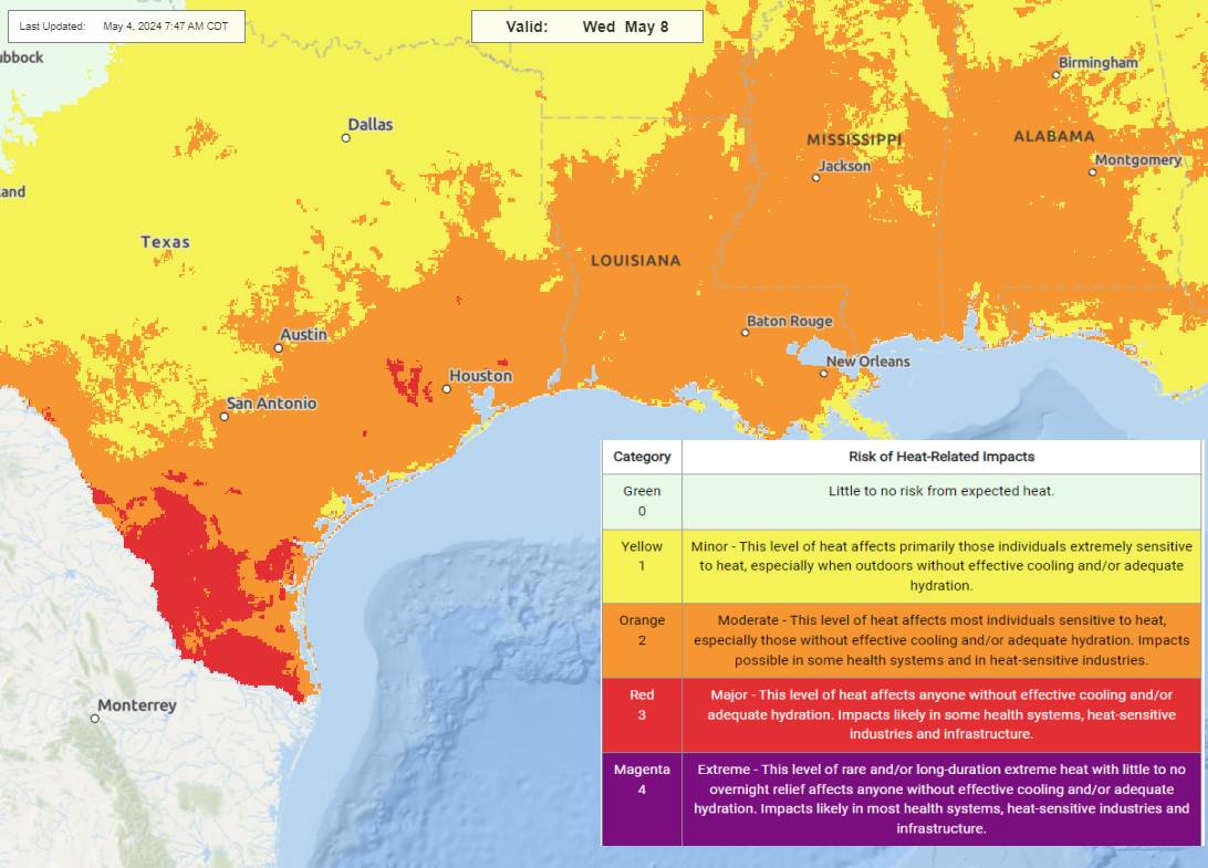
We expect the pattern to begin to transition beginning Monday into the forecast heat for next week. While a few showers or storms are possible, significant weather is not expected on Monday. The main story will be heat next week, building through the week.
Impressive heat will build next week, peaking on Wednesday (shown here) or Thursday, before somewhat cooler weather arrives next weekend. (NOAA)
Heat will build up to “major” levels, as classified by the National Weather Service, with low to mid-90s likely for highs by Wednesday and/or Thursday. Given that this will be our first real heat of the season, give your body some extra time to adjust. We’re not used to it just yet. We’ll have more tomorrow, or later today if necessary on the rain.
In brief: An unexpectedly intense flooding event has engulfed areas north of Houston this week. We discuss that, and the ongoing forecast for the weekend, which could see an additional round of storms on Sunday before things start to dry out next week.
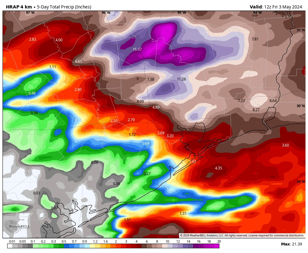
If you live south of Interstate 10, you may be wondering what the fuss is all about in regards to heavy rains this week. Much of this area has received 2 inches or less over the last five days, and certainly not experienced anything remotely close to flooding conditions. However, looking at the rainfall accumulation map below, we can see that eastern Montgomery County got rocked with 12 inches of rain, and further to the north, Walker and San Jacinto counties recorded 15 to 20 inches of rainfall. Some of this came very quickly, with high rainfall rates.
Houston area estimated rainfall from midday-Sunday to midday Friday. (Weather Bell)
And so we have a situation where much of the region is just fine, but there is terrible flooding ongoing along the San Jacinto and Trinity river basins. The most dangerous flooding is occurring along the East Fork of the Jacinto River, but the entire north and northeastern parts of the Houston metro area are dealing with significant and ongoing flooding.
What’s next
So what happens next? After today’s showers, we should see a reprieve for the rest of this afternoon and evening. Our record for predictions this week has been pretty shoddy, but at this point I only expect development of sporadic showers on Saturday morning. And most of Saturday, frankly, looks mostly rain free. At this time I think we’re unlikely to see more than scattered showers and thunderstorms, with accumulations not amounting to much.
Unfortunately, it does appear as though a final storm system will work its way toward the area later on Saturday night, or Sunday morning. This atmospheric disturbance will likely bring widespread showers and thunderstorms on Sunday morning-ish, and perhaps throughout much of the day. As a rough guess we’re looking at additional accumulations of 1 to 3 inches, with the potential for higher totals. This will, unfortunately, only exacerbate ongoing river flooding.
By Sunday night high pressure really should begin to assert itself, and most of next week looks sunnier, and hotter. Rain chances look lower for most of the week, although perhaps not zero.
Given the unpredictability of the storms we’ve seen this week, and the threat of additional rain on Sunday, we’re going to continue with posts each morning this weekend to keep you updated. Thanks as always for reading, and for your patience as we have struggled to grapple with a challenging forecast that has been more miss than hit.
In brief: Flash flood warnings are in effect for Montgomery, far northern Harris, and Liberty Counties this morning, as an additional 1 to 4 inches of rain has fallen. River flooding will continue in those areas as well, with numerous evacuation orders and road closures in effect. Major rain should hopefully exit this morning with more intermittent, scattered downpours through the day. Additional storm chances exist tonight and especially Sunday before the heat sets in next week.
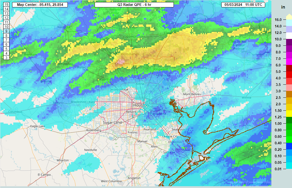
A flash flood warning is in effect north of Houston through 8 AM, as another batch of heavy rain fired up overnight dropping 1 to 4 inches of rain between southern Montgomery, northeast Harris, and northern Liberty Counties.
Rain totals over the last few hours have been as high as 3 to 4 inches just south of The Woodlands. An additional 1 to 2 inches is possible before (hopefully) things settle a bit this morning. (NOAA)
This is not where we wanted to see the rain this morning. We do expect that this will actually move along at a better clip than yesterday’s rain did. Hopefully that leads to some quicker improvement, but all this water will help further swell the river systems up there. You can view flood gauge information on rivers, creeks, and bayous at the National Weather Service or at Harris County Flood Control. Please follow the advice of your local officials, and never drive around barricades.
A Flood Watch remains in effect along and north of I-10, extended through Saturday, and we will maintain our Stage 1 flood alert for Houston.
The San Jacinto and Trinity Rivers remain the two most serious issues at this time. There will continue to be rises and damaging flooding within both systems. Additionally, the Navasota River is expected to crest at record levels north of Bryan. That feeds the Brazos, and we’re likely to see high water or minor flooding begin in that river too as we head into next week. Thankfully, we aren’t expecting a whole lot worse in that system. A lot happening, and we’ll keep you posted on any significant changes with at least one more update later today.
Today
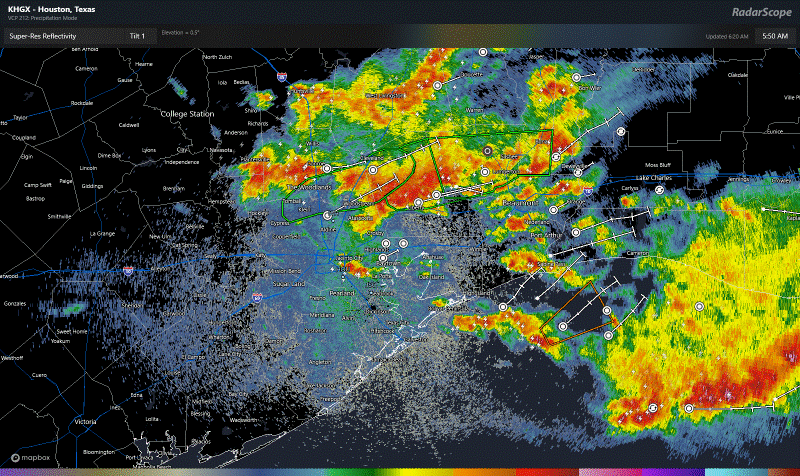
The rest of this morning is expected to see this very heavy stuff north of Houston exit east and be replaced by more in the way of scattered thunderstorms.
Heavy rain should hopefully exit to the east this morning, being replaced by more scattered thunderstorms, notable but more manageable than the current rain. (RadarScope)
If we can pop more in the way of scattered storms, yes, that will lead to isolated heavy downpours, but more often than not it wouldn’t rain over one place hard for more than 15-20 minutes at a time. Even a few rounds of that is more manageable than the deluge and 2 to 6 inch per hour rates we’ve seen this week. We’ll continue watching and keep you posted. Have an umbrella and an indoor backup plan anywhere in the area today just in case. Highs will range from the upper-70s in places it rains persistently to low-80s. Showers should diminish in coverage this evening.
Saturday
Do we expect more showers and storms to fire up overnight tonight and Saturday morning? It’s NBA playoff season, so in the words of Marv Albert, “Yes!” Unfortunately we will probably see additional rains in saturated and flood-impacted areas north of Houston. There is a chance that this ends up being a little less rain than today, so hopefully that’s the case. Otherwise, sun, clouds, and 80s.
Sunday
The back half of the weekend looks to remain unsettled. Another wave of storms could pass through the area in the morning or afternoon hours, especially north of I-10, again. Rainfall could again be heavy, and right now I am a little more concerned about Sunday than Saturday in terms of rain and impacts. Outside of any storms, expect clouds, some sun, and highs in the 80s.
Next week
I wouldn’t be shocked to see one more round of showers or storms on Monday or Tuesday, but then the heat cranks up. Expect upper 80s on Monday, low-90s by Tuesday, and low to mid-90s on Wednesday and Thursday.
NWS forecast high temperatures for next Thursday are…hot. (Pivotal Weather)
It will feel uncomfortably hot, given this is first real heat of the summer season, so take it easy. Morning lows will generally be in the mid-70s. We may see rain chances return toward the weekend but for now that’s mostly speculation, and I wouldn’t be changing any Mother’s Day plans at this time.