Good morning. Today is Juneteenth, a relatively new federal holiday that has its origins in Texas. Juneteenth is celebrated on the anniversary of Major General Gordon Granger arriving in Galveston and proclaiming freedom for enslaved people in Texas on June 19, 1865. This came two and a half years after the Emancipation Proclamation was issued.
Unfortunately, we will not have freedom from extreme heat today. Some very moderate relief will arrive later this week, as well as a slight chance for our first showers and thunderstorms in awhile. But it will probably be fleeting.
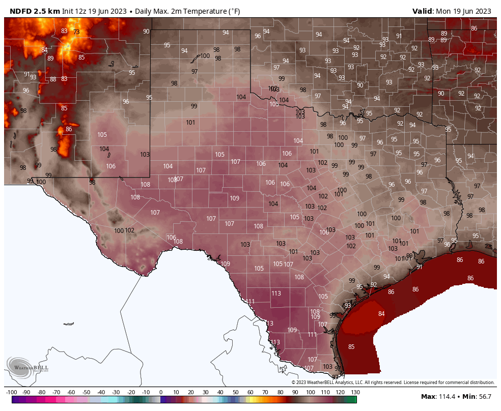
Texas high temperatures on Monday will be one big bucket of yuck. (Weather Bell)
Monday, Tuesday, and Wednesday
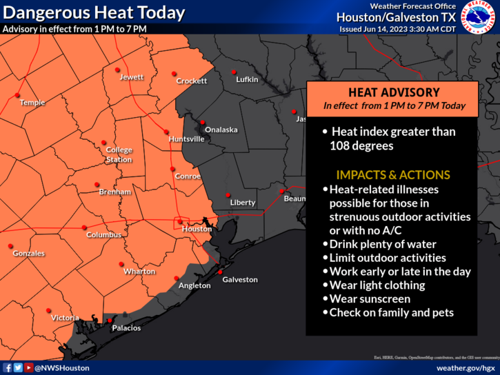
For the first two or three days this week we are going to see conditions very much like what the region experienced over the weekend. That is to say, high temperatures of about 100 to the low-100 degrees with high humidity, leading to an extremely elevated heat index. An excessive heat warning is in effect for now through Tuesday, and we can probably expect that to continue through Wednesday. Please continue to take heat safety precautions when outdoors during the middle of the day.
Thursday and Friday
Sometime on Wednesday, the high pressure system that has dominated our weather for several days will begin retreating slightly to the west, allowing for a cloudier and slightly cooler period. The relief will be modest, with high temperatures likely in the mid- to upper-90s, but it should bring down the dangerous heat index for a few days. Some weak disturbances will also drive rain chances into the area for a couple of days. Do not expect much—most areas probably have a 10 to 30 percent chance of rain—but this is better than what we’ve seen for a week now.
Next weekend and beyond
The medium-term looks pretty hot, I’m afraid. At this point the most likely scenario is that the high pressure system starts to rebuild over Texas, including the Houston metro area. So we probably will see the return of triple digit temperatures, sultry humidity, and heat warnings. I wish it were otherwise.
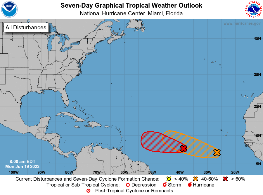
It’s rare to see two tropical waves of note in mid-July, but here we are. (National Hurricane Center)
Tropics
The Atlantic tropics are unusually frisky for this time of year, and we can probably expect the formation of Tropical Storm Bret within the next day or two. The storm, and an additional wave behind it, likely are of no consequence to Texas or the Gulf of Mexico. For full coverage of all things tropics, be sure and check out our new Atlantic hurricanes website, The Eyewall.
We’ve seen a lot of comments from folks on the site and social media along the lines of, “Well, it always gets this hot in summer and always has and this is no different so why are you making a big deal of this?” It is true: Houston is hot in summer. From May through September, you can describe Houston as hot, humid, sultry, or whatever other colorful adjective you want to use. Some may say, the difference between 94 and 98 and 100 is difficult to perceive anyway, so what difference does it make?
An excessive heat warning has been issued for Houston for the first time since August of 2016. It covers the entire region away from the coast. (NWS Houston)
Usually about twice per summer or so, the heat in Houston goes to what I call the next level, where it’s hot like always, but it just feels worse. This is the type of heat where your body can truly suffer if you don’t take it seriously. We’re in one of those periods right now, arguably one of the worst such periods in several summers. Heat index values yesterday were all over the place, including near 115° in spots around Houston and even near 120° in spots near Corpus Christi and Port Arthur. A more typical summer day may feel along the lines of 99 to 105° or so. So this has moved into the higher echelon of next level of heat. Hence, we are trying to convey that this is more serious than normal summer heat. And it will continue for awhile longer. Please take it seriously this holiday weekend, especially if you’ll be attending any of the Juneteenth celebrations in the area or outdoors in any capacity.
We don’t want to be too preachy, but this is more serious heat than is typical for Houston. (NWS Houston)
We have energy saving tips from our sponsor and partner Reliant just below the forecast. As the heat puts stress on the grid over the next several days, these energy saving tips will come in handy.
Friday & Saturday
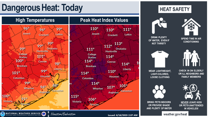
All we can tell you about these two days is that they’re going to be miserably hot and humid. Expect heat index values of 110° to 115° or higher, with actual temperatures near 100° inland and in the 90s along the coast. A heat advisory is posted for the coast, while the rest of the region has an excessive heat warning. The last time the city of Houston had an excessive heat warning was in August of 2016. So, again, this speaks to both the rarity of heat of this magnitude, as well as the fact that it’s June not August.
Heat index values may peak over 115° in spots today and tomorrow, meaning maximum heat safety precautions should be taken. (NWS Houston)
Let’s not forget about nighttime. Low temperatures will struggle to get much below 80 degrees each night. This sort of compounding heat can take a toll, especially on the very young and elderly. If you’re headed to the Gulf for some relief, please also keep in mind that rip currents look a bit strong this weekend, so be aware of that if you jump in the water.
Sunday & Monday
Copy and paste Friday and Saturday’s forecast and tweak the temps by 1 or 2 degrees in either direction. More heat warnings and/or advisories are a guarantee.
Rest of next week
By later next week there’s some chance that we may exit this “max heat” type situation and get back to something just regular “abnormally hot.” So instead of heat index values of 110 to 115°, maybe we fall back to more like 105 to 110° or so. It’s a maybe, but at this point, we’ll take whatever good news we can get.
In terms of rain chances, they remain near zero until perhaps midweek or late week next week, when maybe we can bump them up to 10 or 20 percent on a good day.
A Message From Our Sponsor, Reliant
As Eric and Matt have warned us, the summer heat is here. With triple-digit temperatures forecasted for the coming week, Reliant is sharing helpful tips to stay cool while managing your energy usage.
Setting your thermostat four degrees higher when you’re away from home for more than four hours can help reduce electricity usage.
Raising the temperature of your home by even a few degrees also reduces energy consumption. Every degree of cooling below 78 degrees increases your energy use by 6-8%. While the suggested temperature for ideal energy use in the summer is 78, a comfortable temperature setting is a personal preference – just know every degree makes a difference.
Rotate your ceiling fan counterclockwise for a wind chill effect. This can make the temperature in a room feel up to four degrees cooler, allowing you to be more comfortable and adjust your thermostat to save money. Don’t forget to turn off your fan when leaving the room.
Use blinds or curtains to reduce solar heat gain by up to 50 percent. Direct sunlight can increase the demand on your A/C by as much as 30 percent.
Check air filters monthly and replace as necessary. A clean air filter can keep your A/C running at peak condition.
Avoid using heat-producing appliances like the clothes dryer, dishwasher, or oven during the hottest times of day. These appliances can cause your A/C to work harder to keep your home cool.
Find additional energy efficiency tips from Reliant by clicking here.
Good morning. The story of the day, the story of the week, and the story for the second half of June is going to be our region’s dangerous heat. The National Weather Service has expanded the “heat advisory” to cover the entire Southeast Texas region, including all of the Houston metro area. With temperatures around 100 degrees, and the heat index pushing 110 degrees due to high humidity, it is strongly advisable to limit activities outdoors during the middle of the day.
It’s Houston. It’s humid. It’s Houmidity. Perhaps that’s not a slogan the Greater Houston Convention and Visitors Bureau is going to start using, but it does have the benefit of being accurate.
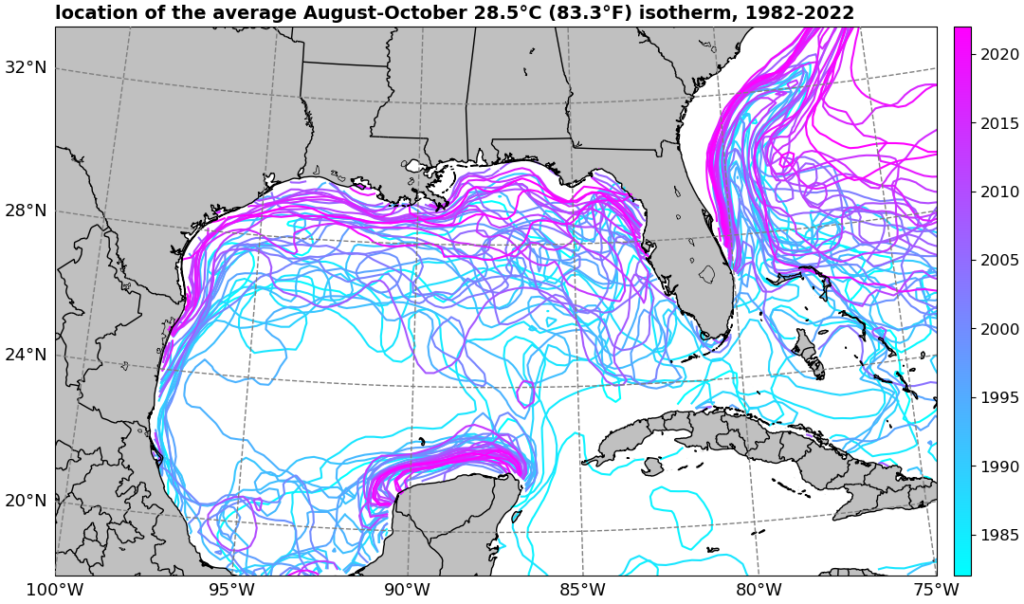
If you’re looking for something a little bit different this morning, over at The Eyewall, Matt authored a feature report about hurricane activity and the Gulf of Mexico. We’ve seen a spate of major storms in the last six years, particularly with rapidly intensifying and extremely damaging hurricanes. Matt dives into the latest research and speaks with hurricane scientists about whether this is really a trend, and what it means for coastal residents.
The location of the average August-October 28.5°C/83.3°F isotherm (line of consistent temperature) has been migrating closer to the Gulf and Southeast coasts since the 1980s, indicating that Gulf water temperatures have been warming, thus becoming more hospitable for stronger tropical systems. (Dr. Kim Wood, Mississippi State University)
Thursday
What is there to say? High pressure is dominating our weather, and this will mean mostly sunny skies, highs near 100 degrees, and southerly winds varying from 5 mph to 15 mph. Nighttime temperatures will offer little reprieve, with lows dropping only to around 80 humid degrees. If you live near the coast, daytime highs will be slightly lower, but the humidity slightly higher. Pick your poison, H-town.
Friday
More of the same.
Saturday and Sunday
The heat peaks this weekend, with much of the area hitting 100 degrees. Expect lots of sunshine. Rain chances remain below 10 percent, daily. Find some water to cool down in if you’re going to be outside.
Feel the burn, Houston. (National Weather Service)
Next week
The first half of next week should bring still more of the same, although there is some suggestion in the models that the ridge will weaken or flatten later next week, and begin to offer some relief. We’re not talking much here, but highs could start to fall back into the mid- to upper-90s. Rain chances by Friday or so may start to tick back up into the 20 to 40 percent range. But that’s eight days out, and I don’t have confidence in the ridge of high pressure breaking down until the models start to definitively show it. In other words, abandon all hope, ye who enter here.
Just what is happening around here? I take off a few days for a family reunion in a cooler climate, and return to sultry, face-melting summer heat and a forecast that includes 100-degree temperatures. I absolutely blame Matt for this and let me tell you, I’ll be writing a stern letter to the managing editor.
Alas, it’s only going to get hotter. And there remains no real confidence in when an end-date might be in sight. It high pressure domes for as far as the eye can see.
Please take care outside today. (National Weather Service)
Wednesday
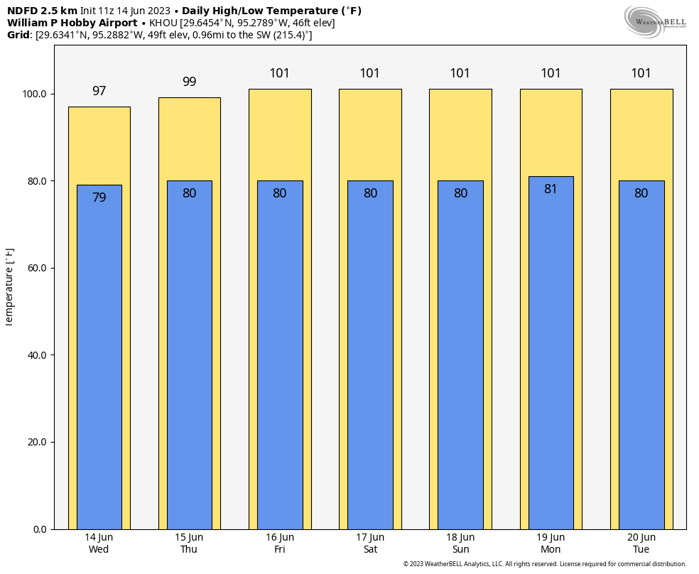
Temperatures remained confined to the mid-90s on Monday and Tuesday in most of Houston, but today we’re going to begin taking another step up. The central and western parts of the metro area will see highs in the mid- to upper-90s, and combined with the high humidity, this will bring dangerous heat to the area. The National Weather Service has issued a heat advisory for the time period from 1 pm to 7 pm CT today for all but the eastern part of our region. Winds will generally be light, at 5 to 10 mph, with slightly higher gusts. Lows tonight will only drop to around 80 degrees.
Thursday
Temperatures will pretty much be in the upper 90s to 100 degrees for the entire area, with the exception of the immediate coast. And if you’ve lived in Houston for more than 10 minutes, you probably don’t need to ask about the humidity.
Friday through Tuesday
We’re highly confident that these will be sunny and hot days, with most of the area reaching triple digits. This extreme heat will be driven by a high pressure system that will lead to sinking air, clear skies, and ideal conditions for daytime heating. Please take precautions with outdoor activities during the afternoon and early evening hours. Rain chances look to be 10 percent, or lower, each day.
Congratulations, everyone. (Weather Bell)
Next Wednesday and beyond
The truth is, there is no concrete sign that high pressure will abate during the second half of next week, so the most likely forecast is one of continued high heat and very low rain chances. Maybe some slight relief will arrive as we get toward next weekend. We’ll see.