Today and tomorrow, Matt and I will be publishing two posts to summarize the 2020 Atlantic hurricane season, its effects on Houston, and implications for the future. In Part I, today, I will discuss the overall activity this season, and share some thoughts about Hurricane Laura. Part II, tomorrow, will focus on Tropical Storm Beta and what we can learn from this season about future hurricane activity.
2020 season
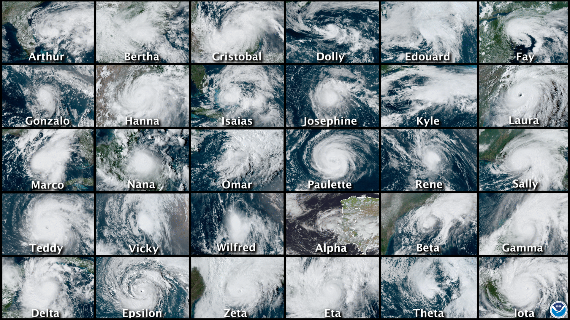
The numbers for the 2020 season are sobering. Across the Atlantic basin—which includes the Atlantic Ocean, Caribbean Sea, and Gulf of Mexico—there were a total of 30 tropical storms and hurricanes. This surpassed the previous record of 28 set in the year 2005, the historic year of Katrina, Rita, and Wilma. For only the second time, this year, forecasters at the National Hurricane Center in Miami ran out of names and had to resort to using the Greek alphabet.
Notably, a dozen of these tropical storms and hurricanes made landfall in the United States, crushing the previous record of nine landfalling tropical storms or hurricanes set in 1916. The state of Louisiana alone experienced five landfalls. (Thanks to the tremendous results of our 2020 fundraiser, Space City Weather will donate $5,000 to SBP, to assist with that state’s recovery efforts). At least one part of Louisiana fell under coastal watches or warnings for tropical activity for a total of 474 hours this summer and fall. And Hurricane Laura, discussed below, became the strongest hurricane to make landfall in Louisiana since 1856.
Harris County’s Jeff Lindner has catalogued some of this year’s other superlatives:
- On September 14, five tropical cyclones were ongoing at the same time in the Atlantic basin (Sally, Paulette, Rene, Teddy, and Vicky). This ties September 1971 for the most number of tropical cyclones at the same time in the basin.
- On September 18, three tropical cyclones formed within in six-hour window (Wilfred, Alpha, and Beta). This is only the second time in recorded history that three tropical cyclones have formed in such a short time period (1893).
- Ten tropical storms formed in the month of September, the most for any month on record
- A total of 10 systems experienced rapid intensification (35 mph increase in wind speed in 24 hours), Hanna, Laura, Sally, Teddy, Gamma, Delta, Epsilon, Zeta, Eta, and Iot).
- Hurricanes Delta, Iota, and Eta experienced winds speed increases over 100 mph in 36 hours or less.
- Of the 6 major hurricanes in 2020, four were in October and November, and bore Greek alphabet names (Delta, Epsilon, Eta, and Iota).
- Hurricanes Eta and Iota both made landfall only 15 miles apart along the Nicaragua coast both as category 4 hurricanes.
- Hurricane Iota (160 mph) became the latest category 5 hurricane on record in the Atlantic basin, and the second strongest November hurricane on record only behind the 1932 Cuba hurricane (175mph)
- NOAA hurricane hunters flew a total of 86 missions for 678 flight hours and 102 eyewall passages. A total of 1,772 dropsondes were deployed.
Despite all of this, however, the 2020 Atlantic season was not all that extraordinary by some important measurements. Perhaps our best tool for determining a season’s overall activity is “accumulated cyclone energy,” or ACE, which sums up the intensity and duration of storms. For example, a weak, short-lived tropical storm counts for almost nothing, whereas a major, long-lived hurricane will quickly rack up dozens of points. The ACE value for the 2020 Atlantic season was 179.8. This significantly higher than the climatological norm for ACE values (about 104), but does not quite make the top 10 busiest Atlantic seasons on record, which is paced by the 1933 and 2005 seasons.
The bottom line is that the 2020 hurricane season was in line with our expectations for 2020 to produce a total cluster of a year. Fortunately, we survived. In Matt’s post on Thursday, he’ll discuss what this may mean for the 2021 season.
Hurricane Laura
It’s also worth reflecting for a moment on what I consider to be the most threatening storm of the year for Houston. There was a time in late August when it appeared that Hurricane Laura might strike Houston as a major hurricane. Personally, it was rather unsettling.
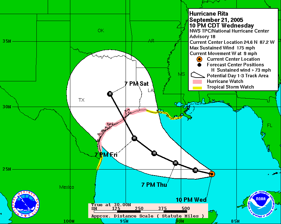
I first began writing extensively about hurricanes back in 2005. This was before I had become a meteorologist, and just after I started a blog for the Houston Chronicle. First, I tracked Hurricane Katrina and then, much closer to home, there was Rita. You may not remember the storm, or it may not have formed much of an impression on you. But it certainly did on me. I distinctly recall the evening of September 21, 2005—a Wednesday. Rita had intensified to 175 mph over the central Gulf of Mexico, and it was forecast to make landfall a little more than two days later just below Houston on the Texas coast. This was the worst-case scenario for our region. I’d bought a home in the Clear Lake area a couple of years earlier. Not going to lie, this one scared me. Eventually, Rita weakened some, and turned, making landfall near the Texas-Louisiana border.
Since then, Rita has been the measuring stick for me in terms of dreading a hurricane landfall. And in those 15 years, no storm has ranked so highly as Laura did in late August. Why? Because although Houston has been battered by a strong storm surge (Hurricane Ike) and massive floodstorm (Harvey) in the last dozen years, it has not seen a major wind storm in nearly six decades. That was the potential Laura had with a track that could have come to Texas, across a very warm Gulf of Mexico. Ultimately, that didn’t happen, Laura turned away from Houston and made a devastating landfall in Louisiana.
Thanks to fine forecasting and smart calls by local officials, the greater Houston area was spared a major evacuation. But Laura was a close call in many ways for the nation’s fourth largest city. And I won’t soon forget it.
Sponsor Note from Reliant
A big thank you goes to the Space City Weather team for keeping Houstonians informed during the 2020 hurricane season. Just as Eric and Matt provide hype-free forecasts to ensure readers are prepared for a storm, Reliant keeps Houston powered with personalized electricity plans and back-up power solutions. Reliant is also here to help before, during and after the storm with helpful guides, tips and information on reliantstormcenter.com. We all hope for a quiet hurricane season in 2021, but know we’ll be informed and in good hands with Eric and Matt should any storms develop. Thanks for all you do, SCW!