Please allow me a few words of reflection this morning before we get to the forecast. (It really hasn’t changed much—2 to 4 inches of rain for much of the area, with the potential for greater amounts possible in some locations. We have some concerns, which we discuss below, but don’t anticipate major, widespread problems at this time).
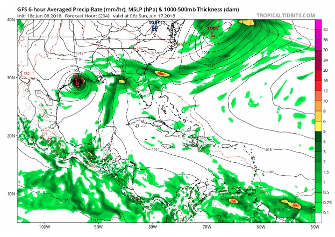
Amazingly we have been talking about the rainfall for “this coming weekend” for nearly a full week. This began late on the afternoon of Friday, June 8, when a couple of local forecasters looked at the GFS operational model (re-posted below) and called attention to the fact that it showed a hurricane moving into Texas on Sunday, June 17. I was taking a family vacation at the time, but received several messages from readers concerned about this, so I asked Matt to write about it. He authored an excellent update titled, “Yes, we saw the Friday PM GFS model; we aren’t stressing.” This kind of perspective is precisely why we started this site.
What concerns me is that we have now been writing about this event for a week, and there is a non-trivial chance that for much of Houston this will not be more than a few significant thunderstorms. This sort of rainfall does not warrant the amount of attention it has received. And if Houston does receive the 2-4 inches of rain over a few days that we anticipate, it will degrade public confidence in meteorology as the hype will not match reality—i.e. the boy who cried wolf. I understand that people are highly sensitized after Hurricane Harvey, but every storm is not Harvey (or even close). So I just wanted to reiterate what I wrote at the outset of hurricane season: “Social mediarology” plays on the fears of people, and therefore tends to get shared widely. If you’ll promise to not fall for these kinds of fear-mongering posts, we’ll make a pledge to you: If we believe there is a credible threat to Houston, we will report that immediately. And if we haven’t written about it, the post you’ve seen on Facebook is probably garbage. Fortunately we have a sponsor like Reliant, which doesn’t value clicks, but rather reliability. Now, on to the forecast.