We hope everyone enjoyed the Christmas holiday. For kids, the two week winter break has just begun, while for many others its back to work today. Weather wise, we are looking at a cold, and often damp forecast to end 2017 in Houston.
Tuesday
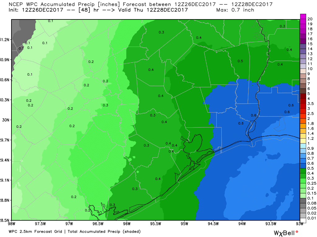
This morning has started out cold and gray, and conditions won’t change much throughout the day. The radar shows drizzle and light rain showers spreading out over the region, and this will remain the story for much of today and tonight. We won’t see much in the way of accumulations—with a tenth or two of an inch of rain on the west side of Houston, and perhaps as much as half an inch through Wednesday morning. Temperatures will remain cold, with gray skies limiting highs to around 50 degrees. Lows tonight will drop into the 40s.
Through Wednesday, rain accumulations should be greater to the east of Houston than the west. (NOAA/Weather Bell)
Wednesday
A cold front will push through the Houston region later on Tuesday or during the overnight hours, and this should bring some marginally drier air. Eventually, this drier air should allow for rain chances to end Wednesday. Even where it does rain Wednesday, accumulations should be slight. The main story will continue to be temperatures, with highs Wednesday likely remaining in the 40s—chilly.
We’ve got one more warm day on tap before cooling off to more seasonable type weather in Houston. That will make four in a row for our area. Let’s explore the details.
Today and Tonight
A mix of a low overcast and some patchy fog around the area this morning. This isn’t a repeat of earlier this week though with dense fog prevalent. That said, we do have some sprinkles or light rain around so roads could be a bit wet in a few spots this morning.
Otherwise, expect a mostly quiet Friday. High temps today will be near 80° in Houston (it’s already 73° as of 7:30 AM). We could see that light rain or drizzle continue. There is a slight chance for a shower I suppose, but it would be most likely up toward College Station or out toward Brenham.
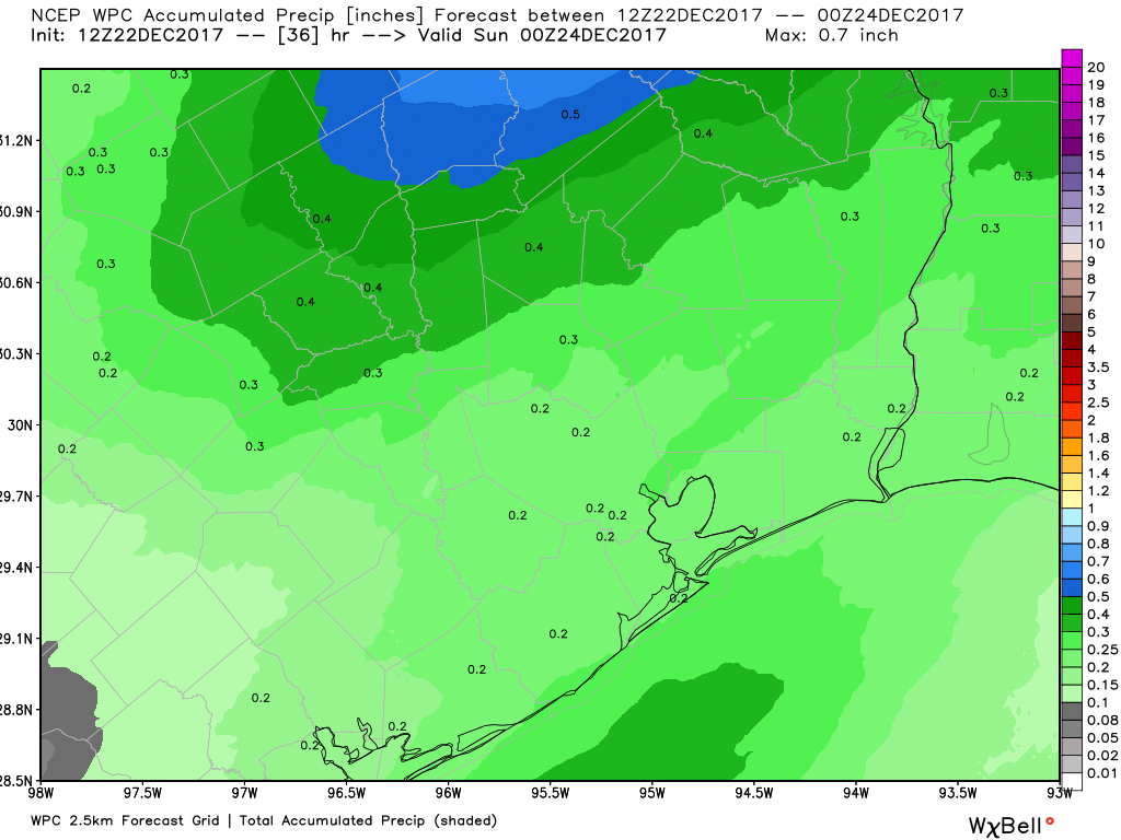
The main rainfall story develops tonight as a cold front sweeps through. Expect showers to become more likely toward sunset. We could see a thunderstorm embedded also, but that would probably be the exception rather than the rule. Rain won’t be terribly heavy and most places should see less than a half-inch, possibly less than a quarter-inch.
Rainfall through Saturday morning should be relatively minor across most of the area. (NWS/Weather Bell)
Showers continue into the overnight hours before gradually ending from northwest to southeast early Saturday morning.
Saturday
We look mostly good on Saturday with clearing likely taking place pretty fast in the morning. We’ll have a mostly sunny afternoon with just a few high clouds around. You’ll notice it’s a quite a bit colder, with morning lows in the upper-40s and afternoon highs sneaking up to the middle or upper-50s. Saturday night will be chilly with lows in the low-40s.
Well, the break was nice while it lasted. Hope everyone got to enjoy yesterday’s mid to upper-70s and sunshine. Today starts another transition.
Today and Friday
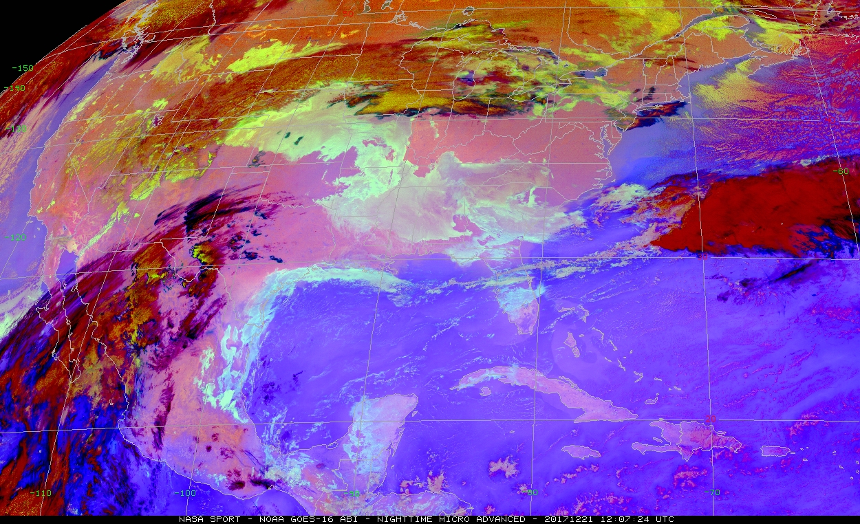
We’re starting with fog or low clouds across parts of the area this AM. Low clouds seem more common than fog at the moment until you get to Louisiana. But we’ll start today with a mix of sun and some of these low clouds. A nice, sunny start is in the cards north and west of the city.
The new, fully operational, GOES-16 (now GOES-East) satellite shows widespread low clouds and fog this morning, especially along the coast. The aqua or gray colors show this best. (NASA SPoRT)
There could be a sprinkle or shower around as well, but it won’t be anything serious. Temperatures will top off in the mid or upper 70s once more this afternoon. Cloud cover may cap how warm we get in spots though. Onshore flow is back in style, and you’ll feel it today. Expect humidity to trend upward through the day with dewpoints climbing out of the 50s and into the mid or upper-60s by evening. That means dense fog will once again be a possibility tonight, though a bit of a breeze may allow the fog to be less prevalent than we saw earlier this week.
Temperatures will only drop off into the mid or upper-60s tonight, or about 20 to 25 degrees above normal for this time of year. After a warm start, Friday looks like a mix of clouds, fog, and a slight chance of rain showers. Expect temps to hit the mid or upper-70s once more. We could do 80° with just a little bit of sunshine. The chance of rain will increase as we get closer to evening. Expect a period of steady rain or showers later Friday night into Saturday morning. There could be a thunderstorm thrown in, but overall no serious weather is expected with this front.
Saturday
Behind Friday night’s front, expect clouds and showers to linger early Saturday. Clouds could clear out from northwest to southeast on Saturday afternoon. Temperatures will be notably cooler. Expect the morning to start with upper-40s or low-50s only warming into the upper-50s to perhaps around 60° Saturday afternoon.
The fog lifted and temperatures exploded yesterday afternoon. Houston managed to hit 79° officially, just a little shy of the record of 81° set back in 2012. This is our fifth day above 75° so far this month. We did eight of them last December, but most came in the final 10 days of the month. We should add at least one or two more warm days to the record this week before a pretty significant dose of winter cold brings us back to reality.
Today
Spectacular. We try not to editorialize the weather too much, but it’s tough to argue against today’s weather by almost any objective metric. I expect today to be a chamber of commerce special, with ample sunshine and just a few high clouds. Temperatures again should reach for the upper-70s. Dewpoints today will be 15 to 20 degrees lower than yesterday meaning drier air is in place. If we hit 79° again this afternoon, it will feel a whole lot nicer than the 79° we hit yesterday.
Thursday through Saturday morning
Our foray into near-ideal weather will end abruptly on Thursday. We could start the day with areas of fog back in the picture. If we don’t, they’ll return with force Thursday night I think. Humidity should skyrocket on Thursday as onshore flow returns. It might be cool and damp Thursday morning, but it will finish downright humid. There could be some showers around on Thursday, but I don’t really foresee anything too substantial and rainfall accumulations should be minor.
Temperatures will start Thursday in the mid-50s and warm into the mid or upper-70s on Thursday afternoon. We may not see temperatures drop very far on Thursday night. The best we’ll do is probably around 65-70° in much of the area, with some places perhaps not dropping below 70° Friday morning. Fog and some isolated showers will play games with temperatures on Friday, leading to perhaps mid-70s. With enough sunshine 80° can’t be ruled out however.
Our next cold front will approach Friday night — or Saturday morning. The timing has slowed down by at least six hours since yesterday and it now appears we won’t see much rain til after midnight Friday night into Saturday morning.
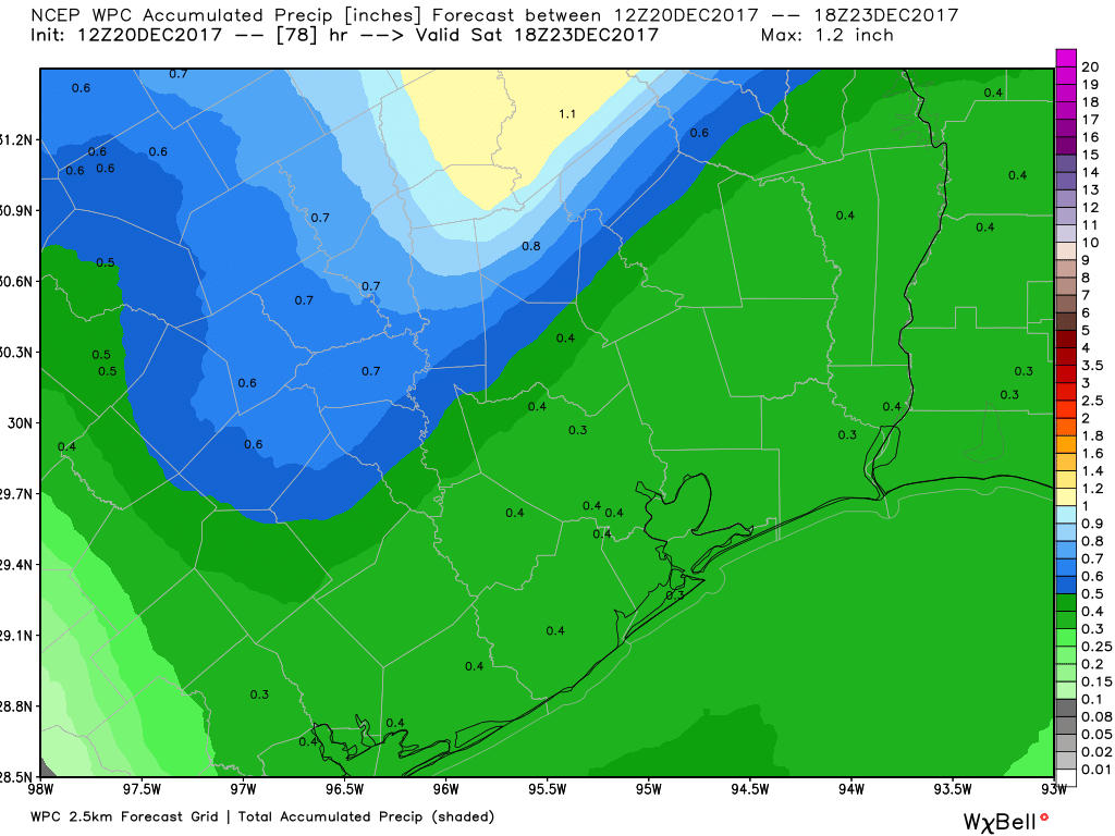
The official rainfall forecast between Thursday & Friday’s showers and Friday & Saturday’s front looks mostly minor. Expect about a quarter to half inch on average, with a few places seeing a little less or a little more. (NWS/Weather Bell)
We could have some thunderstorms with the front as it passes also, but as of now severe weather is unlikely. Behind the front, somewhat cooler temperatures will pour into the region.