Want to know what a storm is likely to do where you are? Dig into your phone’s weather app

In brief: We’re happy to have Dwight Silverman, a longtime Houston tech journalist who is working with us behind the scenes, contribute this post on how to find hyper-local forecast information from the powerful computer in your pocket. Dwight explores some features and data in your phone’s weather apps you may not know existed.

Whenever a storm is bearing down on the Houston area, Eric and Matt are swamped with questions about conditions at individual readers’ locations. They have time to answer a few of them, but given what needs to be done and the volume of work they face, they can’t respond to all of these queries.

But there’s good news: Often, the answers you seek can be found in the palm of your hand.

Nearly everyone carries a smartphone, and many weather apps that are included with them can give you a lot more detail than just the current temperature and rain chances. Some let you drill deep into the metrics you want to know most about a major storm – wind speed and precipitation. Want to know what peak wind gusts will be when a storm is forecast to be nearest you? Or how much rain is expected to fall near you? There is, indeed, an app for that. They’re not perfect, and they don’t do a great job with uncertainty in forecasts, but they offer a solid approximation of what to expect.

This post is not intended to be a manual for weather apps, but rather to shed some light on features you may not realize are there, or are hidden a few layers deep in an app’s design. There are many third party weather apps out there, and I am not going to try to cover them all. But I will offer tips for some of the better one, and those that are included on your phone.

Space City Weather

You may have heard that we have our very own, free app? It’s true, and it’s available for both Apple products (iPhones, iPads, Macs) and Android devices. The app is primarily designed to give you quick access to Eric’s and Matt’s posts, current conditions, hourly and daily forecasts for a week out, as well as radar for any of 12 cities in our region. But one thing you may not realize is that it includes detailed, up-to-date National Weather Service forecasts and advisories on storms and hazardous conditions.

The lower right hand icon on the Space City Weather app home page takes you to the National Weather Service forecasts and current alerts.

Open the SCW app, tap the bell icon in the lower right corner of the screen to get to the Active Alerters as well as short- and long-term advisories. There are also discussions of aviation and marine weather as you scroll down. (Note: The aviation section will NOT tell if your flight has been canceled! Check with your airline, and keep an eye on the FAA’s airport status website.)

Apple Weather

After Apple bought the popular Dark Sky app, it soon redesigned the app that came with iPhones, iPads and Macs to incorporate the former’s hyperlocal forecast features. It will give you details about conditions – both current and future – at relatively precise locations.

However, this integration has been, umm, less than smooth. For example, last year the app was not loading data, and in other instances it was forecasting rain when there was none. The patient seems to have stabilized lately, but it’s a good idea to double-check what you see in Apple’s Weather app with other sources. (You can find where Apple gets its weather data here.)

That said, the app makes it easy to see forecasts for specifc conditions, particularly wind and precipitation, at your location. On the iPhone, iPad and Mac, it shows you conditions in individual tiles, and tapping any of them takes you to a screen that lets you move forward in time to check the the forecast for a specific condition.

Tapping on any of the tiles in the Apple Weather app gets you more detail, including forecast for specific conditions.

For example, if you scroll down on the iPhone to the Wind or Precipitation tiles and tap one, you’ll get the current conditions for the day in a chart. Scroll to the left to move to the next day, or tap the calendar date near the top.

Traveling and want conditions and forecasts for a different location? Enter the ZIP code in the search field. You can save any of the locations for future use. You’ll also see forecast alerts, warnings and advisories for those locations.

Android devices

Unlike Apple devices, which all have the same detailed Weather app, Android smartphones and tablets use different apps and services, depending on who makes the hardware. For example, Google’s Pixel phones use Google’s own weather service for much of its onscreen information, while Samsung and OnePlus phones will kick you out to a weather website, typically Weather.com.

But there is a general strategy you can use: In the five- or seven-day forecast list, choose the day you want to explore and tap it, then look for the metric – wind or precipitation – for the target location.

On a Google Pixel 6 Pro, tapping the weather widget on the home screen goes to Google’s weather information, and from there you can get to specific forecast metrics.

In the image above, tapping on the weather widget that’s the default on a Pixel phone’s home screen, you’re taken to a general weather page. From there, tap the day for which you want details, and scroll down for wind and precipitation forecasts for that day.

Experiment with the app on your Android phone to find the best route to the information you need.

Next, let’s look at a couple of third-party apps that, while not free for all features, may be well worth buying if you live on the Texas Gulf Coast.

RadarScope

RadarScope is one of the best apps for looking at weather radar data that’s available. It’s a favorite of Eric, Matt and mine, and while there’s a limited-capability free tier, it’s worth the $9.99 annual subscription for the Pro 1 level. (There’s a Pro 2 tier, but most folks will only need Pro 1.) It’s available for Apple devices – and when you pay for it once, you can use it on all Apple products, including the Apple TV 4K streaming box. It’s also available for Android devices, as well as Windows-based PCs.

This is indeed a professional-grade app, giving you access to different kinds of radar technologies and views. Once you unlock one of the Pro tiers, you’ll be able to see the direction storm cells are heading, the location of lightning strikes and local storm and damage reports from the NWS’s crowdsourcing MPing app.

RadarScope shows lots of details about storms on radar, here displaying the initial bands from Tropical Storm Beryl as they move toward Houston on the morning of Sunday, July 7, 2024.

You can pick and choose specific radar stations, both in the United States and abroad, including 13 in Texas. It’s easier to use and navigate on a traditional PC, but still extremely useful on your phone. The help files in the desktop version are helpful, and there’s even a Facebook group you can join to learn from other users.

Windy

Windy is available as a website and an iOS/iPadOS and Android app. As the name implies, its initial focus is on wind conditions, but it’s really a full-featured weather app, with one very interesting features: You can track storms based on computer weather models. Choose the model you want, along with the date and time for a forecast, and it animates the storm on a beautifully rendered map.

Windy lets you choose your weather model, then animates its resulting storm forecast on a map.

From the home screen, press and hold the Home icon. Tap the Basic label at the bottom to see the various forecasting models that are available. Choose one to see the storm at the current location, then scroll through the timeline to see where the storm is expected to be based on that model’s forecast.

While most of Windy’s features are available for free, some – like a 15-day forecast – require a subscription, starting at $2.99 a month up to $29.99 a year. But most folks can get along just fine with the free version.

There are many, many other weather apps and websites that can help you keep track of storm developments, and as I said at the outset this is not meant to be an exhaustive list of resources. (I didn’t even mention one of my favorites, Merry Sky, which was developed for those who miss the look and feel of the old Dark Sky app. Oh, wait, I just did!) If there’s an app you like, feel free to let others know in the comments.

Beryl tracking toward Matagorda, center likely to pass near west side of Houston: Serious impacts expected

In brief: We are now less than 24 hours before Beryl will make landfall in Texas, likely near Matagorda, which is located about 90 miles south-southwest of Houston. Along this track the greater Houston area, particularly the western half of the metro area, will see significant effects in the form of strong, battering winds in addition to heavy rainfall. This post will assess all of these threats, and their timing.

Tropical Storm Beryl status

As of 7 am CT, Tropical Storm Beryl still has sustained winds of 60 mph. Its central pressure is largely unchanged overnight, dropping only slightly from 993 to 992 millibars. This indicates that Beryl has yet to begin the process of significantly intensifying. The storm is almost due south of Galveston Island, and is moving to the northwest at 12 mph.

Beryl’s satellite appearance just before sunrise along the Texas coast on Sunday. (NOAA)

It is good that Beryl has not changed much overnight, but forecasters still expect the storm to find favorable conditions for intensification during the next 18 to 24 hours before it makes a final landfall along the Texas coast.

Track of Beryl and its intensity

The trends in the overnight model runs for Beryl have not been great for the Houston metro area. The most likely track remains a landfall near Matagorda, but this could still change today with a wobble in one direction or another as a better defined center of circulation forms. Along this track the Houston region will be subjected to some of the strongest winds and heaviest rains from Beryl.

Forecast track for Beryl as of 7 am CT on Sunday. (National Hurricane Center)

Forecasters still expect Beryl to intensify today, given the lowering wind shear levels and ample moisture in the atmosphere. The National Hurricane Center predicts the storm will be a Category 1 hurricane with 85 mph winds at landfall early on Monday morning. This could be an overestimate if Beryl continues to struggle with getting organized today. However, the most likely scenario is strengthening today, with the potential for rapid intensification tonight. Expect a Category 1 or Category 2 hurricane at landfall.

Conditions on Sunday prior to landfall

Beginning later this morning, Houston may see fairly widespread showers and thunderstorms as the outer rainbands of Beryl move inland. These storms may be briefly intense, but should be navigable for the most part. Winds will be increasing today and this evening from the southeast, but still within manageable levels, with gusts in the 20s. For coastal areas, conditions will start to deteriorate after sunset, with inland areas, including the city of Houston, seeing markedly stronger winds by late evening and after midnight.

Beryl’s winds

Beryl will produce strong winds near its center and to its right. Although there are still likely to be some subtle changes in the storm’s track and location of its is strongest winds, it is now clear that strong winds will cause significant impacts for the greater Houston area, including the potential for widespread power outages. The extent of these outages will depend on the strengthening of Beryl today and tonight as it nears the Texas coast. Other concerns include downed trees and damaged roofs. It is strongly advisable to secure loose objects today, prior to Beryl’s landfall.

The greatest impacts are likely to be in locations such as Sargent, Freeport, and Lake Jackson. However, tropical storm-force winds are also likely along Galveston Island and large parts of the Houston metro area, particularly to the south and west of the city.

Best-guess forecast for Beryl’s maximum wind gusts over the Houston metro area. Note that gusts are higher than the sustained winds by which hurricanes are measured. (National Weather Service)

Matagorda, Wharton, Fort Bend, and Brazoria counties are likely to see the strongest winds, with sustained winds of 45 to 75 mph, and higher gusts. Most of the rest of the Houston metro area is at risk for winds of 35 to 55 mph, with higher gusts. If you’re wondering how these compare to Hurricane Ike, here is a map of sustained peak winds during that notable 2008 hurricane.

These winds will peak between late Sunday night and sunrise for coastal areas, and a little bit later for inland areas. Winds will be receding area-wide by Monday afternoon.

Beryl’s storm surge

Storm surge occurs when a hurricane’s winds align with the onshore flow, pushing large amounts of water onto land. Its most significant impacts occur over immediate coastal areas, and the storm surge level typically peaks along with high tide. In Beryl’s case, water levels are already higher than normal with the storm’s winds. Surge levels should peak between 6 am and 9 am CT on Monday before rapidly receding later in the day, likely reaching near-normal levels by Monday night.

Due to Beryl’s track, expected storm surge levels have ticked a little bit higher. Galveston Island and Galveston Bay should now see a surge 3 to 5 feet above normal levels.

Peak storm surge levels. (National Hurricane Center)

Inland rainfall potential

Beryl’s track also places the core of its heavier rains over the Houston metro area. Coastal areas are likely at the highest risk for heavy rainfall, with 5 to 10 inches likely from Matagorda Bay to Galveston Island, and higher isolated totals. Further inland, much of the Houston area can probably expect 4 to 8 inches, with higher isolated totals. Since this rainfall will come down rapidly, we can expect streets to rapidly flood.

NOAA rain accumulation forecast from Beryl. (National Weather Center)

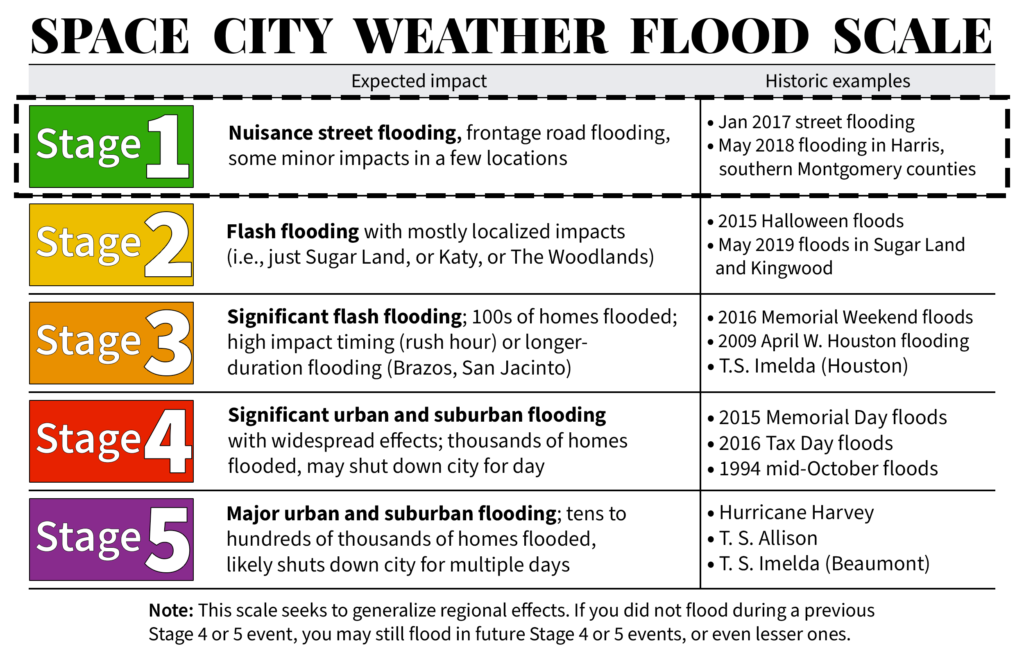
Although stronger thunderstorms will be possible this evening, the most intense rainfall should occur between midnight tonight and noon on Monday. After this time the storm will be pulling away to the north of the city. I cannot rule out an additional trailing band of rainfall later on Monday or Monday night. However, the fairly rapid northward movement of Beryl after landfall is our friend. We have issued a Stage 2 flood alert for the entire Houston metro area.

How should you be thinking about this

Beryl will be an impactful storm for the Houston region. This is far from a worst-case scenario hurricane for our area, but it will be significantly disruptive tonight and on Monday. Beginning this evening, you should shelter in your home. The worst of the winds and rains will come tonight and into Monday morning, with improving conditions thereafter. Due to the likelihood of street flooding on Monday morning, you should carefully consider any plans before noon.

The current track forecast indicates the possibility of widespread power outages, and the duration of these outages will depend on how many people lose power as it will mean more work for restoration crews.

In terms of programming, I will be conducting a video Q&A on our Facebook page at 1 pm CT today. You can submit questions in the comments below for that chat, if you like. Dwight will also have a post today about maximizing the potential of weather data on your phone to understand local conditions during the height of the storm. Our next major update on Beryl’s track and its implications for Houston will come around 4:30 pm CT today.

Saturday Night Live: With your host, Beryl, and featured musical guest, Katrina and the Waves

In brief: Just a few thoughts to share on Tropical Storm Beryl tonight—basically some things I’ll be looking for on Sunday. If you’re looking for a nuts-and-bolts forecast of what impacts to expect in Houston on Monday, please see our post from earlier today, which holds up fine tonight. We’ll have a comprehensive update for you first thing in the morning.

When will Beryl start intensifying again?

As of late Saturday night, Beryl remains a high-end tropical storm with 60 mph winds. Its intensity has not changed much today, as expected, due to shear and entrainment of dry air. However, as we’ve been discussing, Beryl is moving into a more favorable environment tonight and on Sunday, and therefore it is virtually certain to re-strengthen.

The National Hurricane Center forecast for Beryl, at 10 pm CT on Saturday night, brings the storm center to the west of Houston. (National Hurricane Center)

One key question at this point is when Beryl starts to rev back up. This is because once Beryl starts to increase its winds, it likely won’t stop intensifying until it runs into Texas. So on Sunday I’ll be watching to see how soon Beryl’s winds start to increase, and how fast its central pressure (currently 993 mb) starts to fall.

The National Hurricane Center forecasts Beryl to come ashore as a Category 1 hurricane, with 85 mph winds. However, the forecasters there acknowledge that Beryl could rapidly intensify in the final hours before it comes ashore as the system reaches an environment with significantly lower wind shear. In addition, historically, we have seen hurricanes intensify as they near the Texas coast. The bottom line is that the later Beryl starts intensifying, the better, as it could easily become stronger than a Category 1 hurricane.

A silver lining: Beryl is moving at a good clip

One bit of good news is that the storm is moving a bit faster than expected, so it will have less time over water to get going. Some of our best models, including the European and GFS models, now bring the storm to the Texas coast around 2 to 4 am CT on Monday, several hours faster than previously thought. This will give Beryl less time to rapidly intensify.

The forward motion will also help with rainfall totals, both at landfall and after it moves onshore. Houstonians are justifiably jumpy when it comes to inland rainfall from hurricanes after Harvey, and this storm will make landfall only a little way up the coast from where Harvey did. But Beryl is no Harvey. In fact, the forecast for Beryl’s forward motion after landfall is also trending faster. So while I do expect to see some very intense rainfall in the Houston metro area on Monday, increasingly it looks as though the heavy rain will exit to our north by Monday night or early Tuesday.

We should have better clarity on Beryl’s impacts in Houston by tomorrow, as we’ll be less than a day before landfall. The bottom line is that everyone in the Houston area, but especially residents south and west of the city, should be prepared for heavy rainfall and higher winds on Monday. How much rain, and how strong the wind will be is something we’ll try to fully pin down in tomorrow’s forecast. This will, of course, depend to some extent on the rapid intensification (or not) of Beryl discussed above.

Have a good night, everyone.

Beryl likely to pass near the Houston area on Monday, bringing winds and heavy rainfall

In brief: We’re less than two days before the landfall of Beryl and there are still plenty of questions about the severity of impacts in Houston. This post will attempt to answer those that we can. In terms of planning, it is becoming increasingly clear that Monday, perhaps from the pre-dawn hours into early afternoon, will be the most impactful time for severe weather.

Status of Beryl on Saturday afternoon

Good afternoon. As of 4 pm CT, Beryl remains a strong tropical storm with 60 mph winds and a slowly dropping central pressure. It’s movement is northwest, and it remains on course to make landfall in Texas on Monday, likely during the morning hours. There remains a fair bit of uncertainty about precisely what winds, surge, and rainfall the greater Houston area will experience.

Zoomed in image of Beryl 4pm CT Saturday forecast track and cone of uncertainty. (National Hurricane Center)

You’ve probably noticed the showers and thunderstorms—there has been a lot of thunder and a lot of excited dogs down my way—this afternoon. These storms are not directly related to Hurricane Beryl, but rather are due to a dying front meeting up with the sea breeze and having a party with the peak heating of the day. These storms should sag toward the southwest this evening before fading out by or before sunset. After that we can expect a quiet night, I think.

Starting on Sunday, perhaps by noon, we may see our first rains from the outer bands of Beryl. However, there should be few mobility issues with making final preparations before the hurricane reaches the Texas coast. I expect stronger winds to begin reaching the coastal areas on Sunday evening, so if you live in places such as Galveston Island or Freeport, you’ll probably not want to be out too late. After midnight our region will start to feel the full effects of Beryl, and which I’ll talk about below.

However, before jumping into the forecast I want to share a couple of housekeeping notes.

Housekeeping notes

Find us: There are lots of ways to find and follow Space City Weather online, and to be sure you know when we post updates. We’ve created a page to help you find us on social media, via our (absolutely free) app for your phones and tablets, an email newsletter, and more.

Video Q&A: I’m planning to conduct a Facebook Live on Sunday at 1 pm CT. The purpose of this will be to answer your questions over the course of about 20 minutes (or longer, if there are more questions). You can queue up questions in the comments below, or on Facebook. We’ll also be taking questions live, during the event, which will take place on our Facebook page.

Beryl’s track and intensity

As expected, Beryl is spending most of today fending off dry air to its south, and wind shear to its southwest. The storm is starting to develop better organized thunderstorms, however, and it should slowly begin to intensify tonight. Sunday and Sunday night will present a more favorable opportunity for intensification, and the National Hurricane Center brings Category 1 hurricane to the coast on Monday morning. However, the storm could be a bit stronger than this as historically we have seen hurricanes quickly gain intensity as the near the Texas shore.

Beryl is still battling dry air to its south this evening, but it is pulling away from it. (NOAA)

We are now only about 36 to 48 hours away from a final landfall along the upper Texas coast. But there remains a decent amount of uncertainty in the final landfall location, and even 50 or 100 miles matter since the storm is going to come inland relatively close to Houston. Our forecast models are pretty good, but we’re talking about relatively small errors that can still be caused by a wobble or two.

What I’m trying to say is that Houston is sort of on the edge: Depending on which way Beryl goes in the last day and a half we could see anything from fairly minor winds to near hurricane-force gusts; and a few inches of rainfall up to 10 inches or more. So my main message here is to be prepared for some serious disruptions in power and mobility on Monday, and if we’re lucky these issues will turn out to be minor. The forecast conditions outlined below are consistent with the latest operational forecast from the National Hurricane Center, which is the most likely (but not certain) outcome.

Timing and severity of Beryl’s impacts on Houston

There are three main impacts from Beryl, winds, storm surge, and heavy rainfall. Let’s go through the latest thinking on each of them.

Winds: Tropical storm-force winds could reach the upper Texas coast by Sunday evening. Generally, areas along and west of Interstate 45 have the best chance of experiencing tropical storm force winds of 39 mph or greater, with higher gusts. In terms of potential power outages, I’m most concerned about Brazoria and Fort Bend Counties, and areas generally south and west of Houston. Again, the extent of our concerns about power losses will be driven by the potential for last second wobbles which will (or will not) bring the core of stronger winds closer to Houston.

Probability of tropical storm-force winds from Beryl. (National Hurricane Center)

Storm surge: Our thinking on storm surge has not changed much, with 3 to 5 feet expected along Galveston Island, and 2 to 4 feet possible in Galveston Bay. This surge is likely to peak on Monday morning, as Beryl nears land, and on top of high tide. Tide timings vary by location, but generally the highest water levels should be anticipated between 6 am and 9 am CT.

NOAA storm surge forecast for Beryl. (National Hurricane Center)

Rainfall: We’ve issued a Stage 2 flood alert for the entire Houston metro area, but like with Beryl’s winds, the risk for flooding is greatest along and west of Interstate 45. My best guess is that the strongest band of thunderstorms will move through Houston sometime on Monday morning, perhaps between sunrise and around noon. This likely will produce the most intense rainfall, and the greatest potential for rapidly flooding streets. If you have plans to be out and about Monday morning, please be very weather aware. In terms of accumulations I think most of the area will pick up 4 to 8 inches of rain, which is mostly manageable. However, due to the tropical nature of this rainfall (which leads to high rainfall rates) some isolated areas may pick up as much as 12 or even 15 inches. That’s … less manageable.

NOAA rain accumulation forecast for now through Friday. (Weather Bell)

A note about flight cancellations

I mentioned this about three weeks ago, but I wanted to reiterate that we hear you on flight cancellations. It’s a major concern with inclement weather. I totally get the anxiety. However, neither Matt nor I are aviation meteorologists or pilots. Unfortunately, we don’t have any special expertise or insight into the decision-making at airports that lead to flight stoppages, nor the cancellation of flights. We try to be helpful, but we’re never going to be able to give you the certainty on this issue that readers want. With all that said, my general expectation is that heavy rain or winds may well disrupt and even cancel some flights on Monday or (less likely) Tuesday.

Our next update

We’ll be back late this evening, probably between 10 and 11 pm CT, with a short update on track, intensity, and some thoughts on whether Houston is likely to experience milder or more serious effects from Beryl. We will, of course, have full coverage on Sunday.