In brief: Today’s post discusses high winds expected over the Houston region this week, and our warm temperatures. Depending on clouds, some locations may hit 90 degrees. A strong front arrives this weekend and brings a chance of storms on Saturday. Next week looks much cooler and drier. Also, it’s bird migration time. We provide a way to track the nocturnal activity of these friendly fliers.
It’s bird migration time
I had a little fun with the headline this morning, but the reality is that April is the prime month for birds to migrate north across Texas from tropical South America and Mexico. There’s a fantastic resource called BirdCast which uses a variety of tools to track such migrations over Harris County, including weather radars and local observations. For example, the site estimates that about 600,00 birds flew overhead last night.
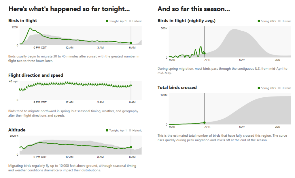
Migrations are also greater when winds are from the south, as this assists the flight of the birds, and we’re expecting fairly pronounced southerly winds this week. (Hence, this weather really is for the birds). Although birds will typically fly at 1,000 or more feet up in the atmosphere, they may stop to rest in our parks and coastal sanctuaries. If you want to help, you can turn out lights at night, as these can prove disorienting to birds. This video from Cornell University’s Lab of Ornithology offers much more information about all of this.
Wednesday
I wasn’t kidding about those winds. We are seeing gusts this morning of 30 mph, or higher, across much of the area, and we’re going to see fairly gusty conditions from now through Saturday. Winds should peak during the afternoon hours. Our high temperatures today will be determined by the extent to which we see clearing skies this afternoon, but my sense is that most areas will see enough clouds to hold highs in the upper 80s. But it’s still going to be quite warm and humid outside, especially with dewpoints around 70 degrees. There is a very slight chance of some showers, and possibly a thunderstorm or two north of Houston this afternoon and evening. We’re likely talking areas along and north of Highway 105 here, so most of the Houston region should experience none of this.
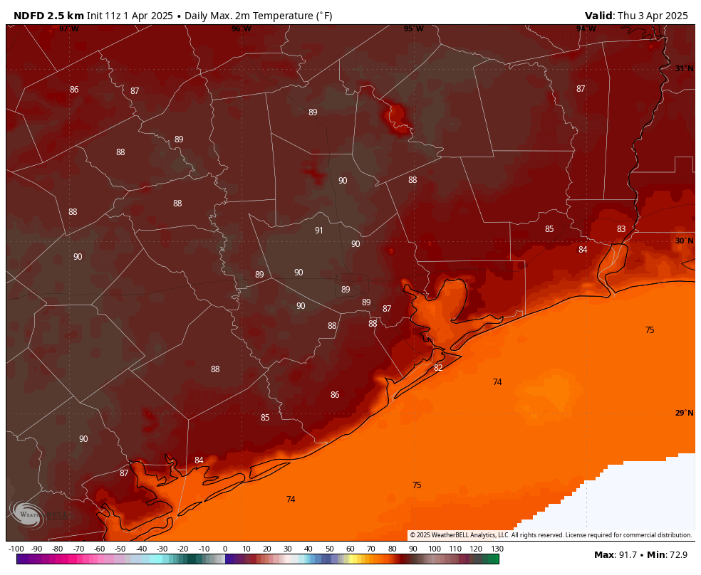
Thursday and Friday
These look to be similar days, with gusty southerly winds and temperatures slotting in between the mid-80s and 90 degrees depending on cloud cover. Thursday probably has the best chance to be sunny during the afternoon, so that’s when most of the area probably will make a run at 90 degrees. It will be humid regardless, with warm nights. Both days will have about a 10 percent chance of some showers, so most of us will be dry.
Saturday and Sunday
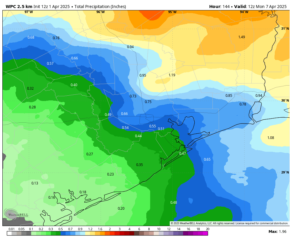
A strong cold front will push through the area on Saturday, likely during the daytime hours. This should bring a good shot of rain with it, along with the potential for severe thunderstorms. Although the dynamics for strong storms look better to the northeast of Houston, we certainly cannot rule out impacts in the city. We are talking about the potential for heavy rainfall, brief street flooding, damaging winds, hail, and possibly a tornado. Again, none of these are certainties or perhaps even likely, but conditions are such that they’re possible. (Much of the city probably will see 0.5 to 1 inch of rain, for example). We should have a better idea about the overall threat in the coming days. The bottom line is that you should be prepared for the possibility of inclement weather on Saturday, especially in Kingwood and points to the northeast.
Depending on the timing, temperatures probably will reach the low- to mid-80s before the front trundles through. Lows on Saturday night will likely drop into the low 50s for much of the area. Some slight rain chances linger on Sunday, but I expect clearing skies at some point during the day. Highs probably will still only max out in the 60s.
Next week
Most of next week looks sunny and spring-like. Seriously, if you like mild temperatures and dry air, I’d advise soaking next week up. We should see daytime temperatures in the 70s and nights in the 50s through Wednesday or Thursday before we warm back up into the 80s. In addition to lots of sunshine we can expect much lighter winds for the most part. Cannot wait.