In brief: The weather over the next 3 or 4 days looks stellar, seasonably mild, and quiet in Houston. Outdoor activities will be just fine. The return of dreary, possibly foggy weather awaits us after Monday. Our next front is penciled in for next weekend.
Yesterday’s rainfall did little to the region, with most areas seeing under a quarter-inch. A narrow corridor from Bellaire through the Timbergrove saw between a quarter and half-inch, as did the area from Alvin through Baytown and Mont Belvieu. The real heavy stuff fell from portions of Hill Country (which is good because they need it) all the way through Dallas and to just west of Texarkana. As much as 4 to 5 inches of rain fell between Dallas and the Red River.
Now, we move on to blue skies and a top 5 weekend of the year.
Today through Sunday
It may take a minute to clear out all the clouds today, especially southeast of Houston. But in general, all three days should be mostly sunny. Really, just near perfect weather. Look for highs in the 60s today with a bit of a breeze, near 70 tomorrow, and into the mid-70s on Sunday. Humidity should stay low. Morning lows should be generally in the 40s tomorrow and Sunday.
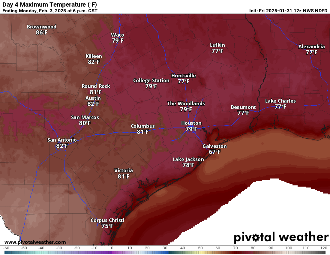
By Monday we have a shot to begin hitting 80 degrees away from the coast. (Pivotal Weather)
Monday
We’ll start next week in transition as onshore flow becomes firmly established in the area, bringing in Gulf moisture, driving up our humidity, and ensuring we see cloud cover. Monday will be in flux, so still look for sunshine, but some possible areas of fog could crop up near the coast through the day. Depending on how much sun we see, we could test 80 degrees Monday afternoon after lows in the 50s.
Tuesday and Wednesday
These will most likely be gray days in the Houston area, especially for the first half of the day.
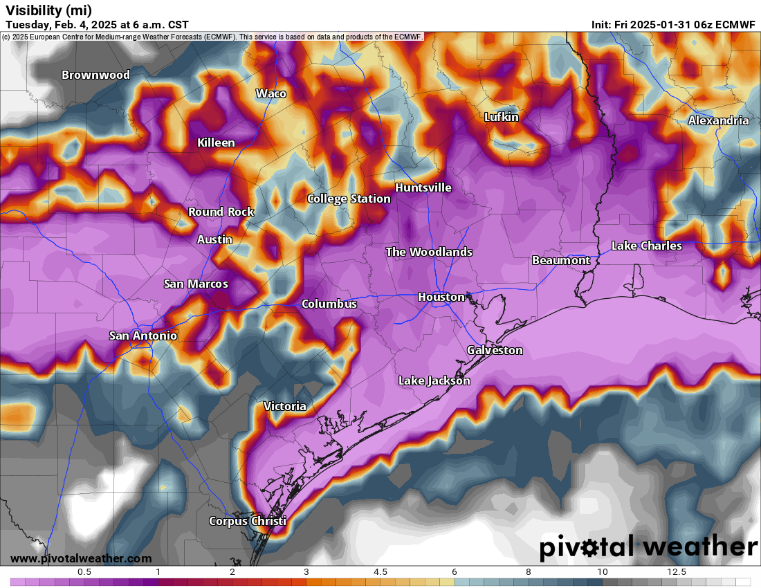
The potential for widespread low clouds and fog (purple) is rather high next Tuesday and Wednesday. (ECMWF model via Pivotal Weather)
With warm and humid air crossing the cooler nearshore waters of the Gulf, that’s a good recipe for low clouds and fog. How widespread it is and how long it sticks around each day is still uncertain, but I would anticipate morning low clouds and fog giving way to some breaks of afternoon sunshine. Areas near the coast may stay fogged in all day. We’ll likely see highs in the 70s and lows in the 60s, but we could push or pass 80 degrees with enough clearing each afternoon.
Next front?
It’s still a bit early to speculate, but it does look like our next front could come with a decent push of colder air. Not a freeze by any means but perhaps cooler than we’ll have seen since early this week. The timing is likely to be roughly next Saturday, give or take 12 to 24 hours. This front should come with at least a few showers and thunderstorms, but I wouldn’t set my expectations too high at this point.
In brief: Houston faces the potential for a few thunderstorms as a cold front rolls through the area this afternoon. Once it moves offshore we’ll see several splendid, sunny days through the weekend. Next week looks warmer, and decidedly spring-like.
Thursday
A line of showers and thunderstorms associated with a cold front is near Austin and Waco this morning, and it will move steadily southeast toward Houston today. It is likely to reach areas west (Katy) and north of Houston (The Woodlands) by or before noon, and push off the coast by around 4 or 5 pm CT. For most of us, I expect these to be briefly passing showers, but some areas may see thunderstorms and damaging winds. Ahead of the front expect temperatures in the lower 70s, dropping 10 degrees after its passage. Lows tonight will fall to around 50 degrees in Houston.
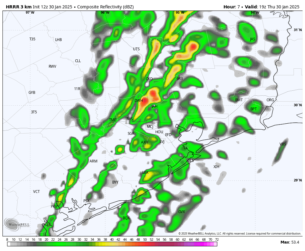
Simulated radar reflectivity for 1 pm CT today. This is for illustration purposes only. (Weather Bell)
Friday
Sunshine returns on Friday, with much drier air. We’ll see gusty winds from the north, perhaps reaching about 20 mph, during the daytime. Highs will likely rise to near 70 degrees. As winds die down we’ll see our coldest night on Friday night, as temperatures dip into the 40s by Saturday morning.
Saturday
This will be a fine day for just about anything. Expect low humidity and high temperatures of about 70 degrees. Skies will be clear and sunny, with light winds. Lows on Saturday night will fall to around 50 degrees in Houston, with cooler conditions further inland.
Temperatures on Saturday morning should be the coldest of the forecast period. (Weather Bell)
Sunday
As the flow turns more southerly, conditions on Sunday will be a tad warmer, with highs perhaps reaching the mid-70s. Skies will remain sunny, however. Lows on Sunday night will only drop to around 60 degrees in Houston.
Next week
This will be the warmest week of 2025 so far, and feel much more spring-like than winter-like. Expect highs in the mid-70s to 80 degrees, with a mix of sunshine and clouds. With dewpoints in the 60s it will feel modestly, but not oppressively humid. Nighttime lows will be in the 60s. There probably will be some scattered showers on some of the days, but I don’t see a huge signal for any rain showers. It does look like some sort of front arrives by next Saturday or Sunday to cool us down, and remind us that it’s still February. My guess is that it knocks lows back into the 40s, but we’ll just have to wait and see.
In brief: There’s a little something for everyone in today’s forecast. We’ve got clouds and some rain during the next couple of days before a nice stretch of sunny and low-humidity weather to take us through the weekend. Only thing to watch for is the low-end potential of some storms on Thursday afternoon.
Wednesday
It’s a fairly dreary morning outside, with light, misty rainfall and areas of fog. This drizzle and fog may persist for much of the morning before we’re simply left with a layer of clouds. With a warmer, southeasterly flow in place we can expect temperatures to warm to about 70 degrees this afternoon, with increasing humidity levels. A chance of drizzle remains overnight, as lows only drop into the lower 60s.
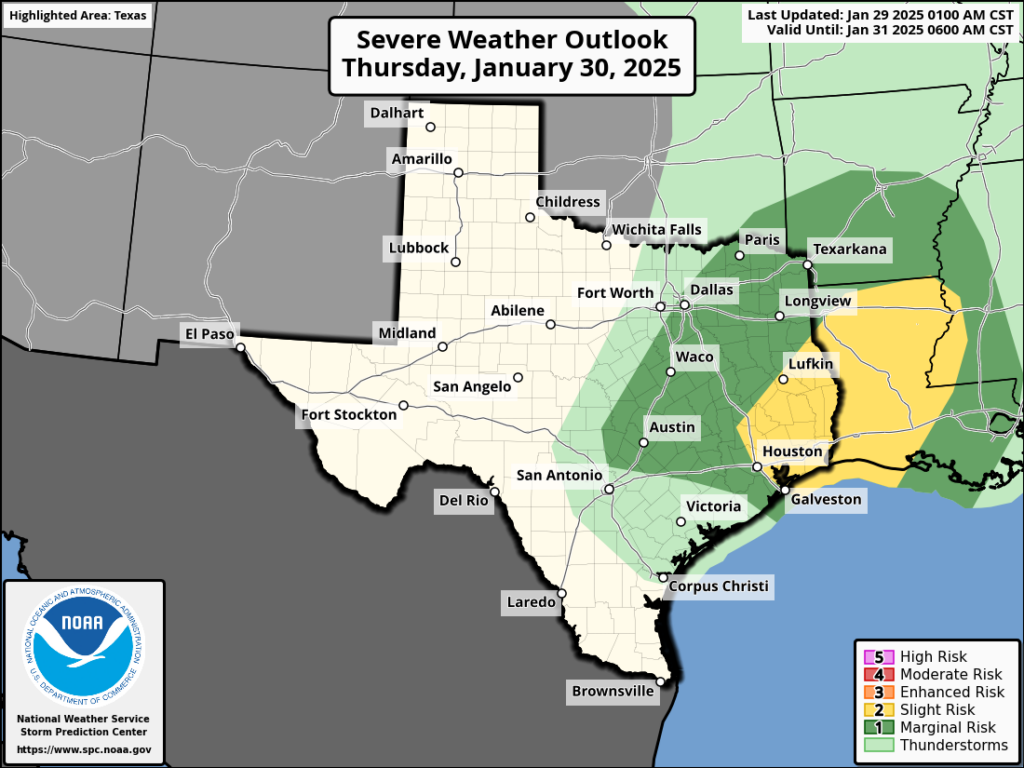
NOAA storm outlook for Thursday and Thursday night.
Thursday
This will be a fairly warm day, despite the cloudy skies, as high temperatures rise into the mid-70s with humidity to match. Some scattered showers will be possible during the morning hours, along with gusty southeasterly winds. During the afternoon, a cold front will approach the area, likely reaching Katy and Tomball an hour or two after noon. What I think we’re likely to see is a broken line of showers that may possibly fill in as it moves through Houston during the afternoon. There is a slight chance of some severe weather with the front, and this is most likely to occur as it passes to the east of the Interstate 45 corridor. This includes the potential for severe thunderstorms or damaging winds. (There is a very low-end chance of hail or a tornado). For most of us, the front should be a fairly modest event, with drier air moving in behind. Lows will drop into the low 50s on Thursday night with clearing skies.
Saturday morning looks to be the coldest of the week. (Weather Bell)
Friday, Saturday, and Sunday
Sunshine is back on the menu, along with a nice slug of drier air and sunshine. Winds from the north will be a bit gusty on Friday morning, but should back down after that. We’re looking at highs on Friday and Saturday of around 70 degrees, with temperatures at night falling into the mid- to upper-40s. Sunday will be a little warmer, with highs in the lower- to mid-70s, but still with plenty of dry air. I can’t wait to take a long bike ride and soak up some sun.
Next week
The atmosphere turns a bit messier next week, but generally I expect we’ll see warm, partly sunny days with highs in the 70s, and nights with lows around 60 degrees. There may be some slight, daily rain chances. Some kind of front works its way toward Houston by the weekend, but an Arctic blast it will not be.
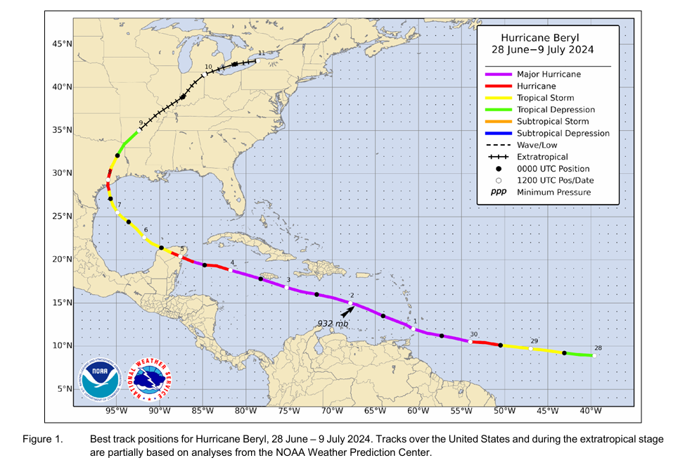
In brief: The National Hurricane Center released their post-storm report on Hurricane Beryl late last week, bumping its landfall intensity in Texas from 80 mph to 90 mph. The report also features a number of nuggets of information, statistics, and images. This post summarizes some of the highlights.
(NOAA NHC)
Hard to believe it’s been over 6 months now since Hurricane Beryl thrashed the Houston area. As is customary, the National Hurricane Center released their post-storm analysis on Beryl late last week, and there were some notable changes to the storm’s history. It is important to be clear that this is a common thing. When the storm is hitting, forecasters are consuming so much data and issuing constant updates that they don’t always have a chance to lock down all the finer details of the storm. In the postseason, there is the the luxury of being able to scrutinize all available data to make an objective determination of a storm’s data points. National Hurricane Center forecasters do this with every storm.
Beryl was a strong category 1 storm
While Hurricane Beryl was presumed to have a landfall intensity of 80 mph when it came ashore in Texas, the postseason review determined that this was too low. Beryl got an upgrade to a strong category 1 storm, with 90 mph maximum sustained winds at landfall. This is interesting, and it makes the comparisons to Ike somewhat more relevant in a data sense.
Ike came ashore as a weakening category 2 storm with 110 mph maximum sustained winds. Beryl came ashore as a strengthening category 1 storm, having rapidly intensified from a 60 mph tropical storm to a 90 mph hurricane in about 14 hours. While that’s still 20 mph of difference in maximum sustained wind, the fact that the two storms were trending in opposite directions, and all else the same, the weaker side of Ike wasn’t that much stronger than the “dirty” side of Beryl, which Houston experienced. This makes the similarities between the storms in terms of widespread tree damage and power outages more comprehensible in retrospect.
Also worth noting, Beryl peaked in the Caribbean as a category 5 storm with ~165 mph maximum sustained winds, confirming the intensity reported in the advisories. The report stated that “the maximum intensity of Beryl is somewhat uncertain due to temporal gaps in the aircraft data near the time of peak intensity, and issues with (microwave) surface wind estimates that prevented their use in this evaluation.” In other words, some of the data was unusable, and the timing of the reconnaissance flight into Beryl may have differed from the exact time of peak intensity. Whatever the case, 165 mph is dang strong.
Beryl didn’t weaken immediately at landfall
One reason Beryl came in stronger than the typical category 1 storm is that the storm likely continued to strengthen just beyond landfall. Where the storm came ashore is not exactly terra firma. Given the geography around Matagorda Bay, the technical landfall may have occurred before the storm truly got on land. The NHC determined this by noting that the minimum pressures recorded near the Texas coast occurred after landfall, indicating that the storm had passed but pressures were still lowering instead of rising as is typically the case. Basically, much like a large ship trying to make a 180° turn, Beryl needed a moment before it could tap the brakes.
(NOAA NHC)
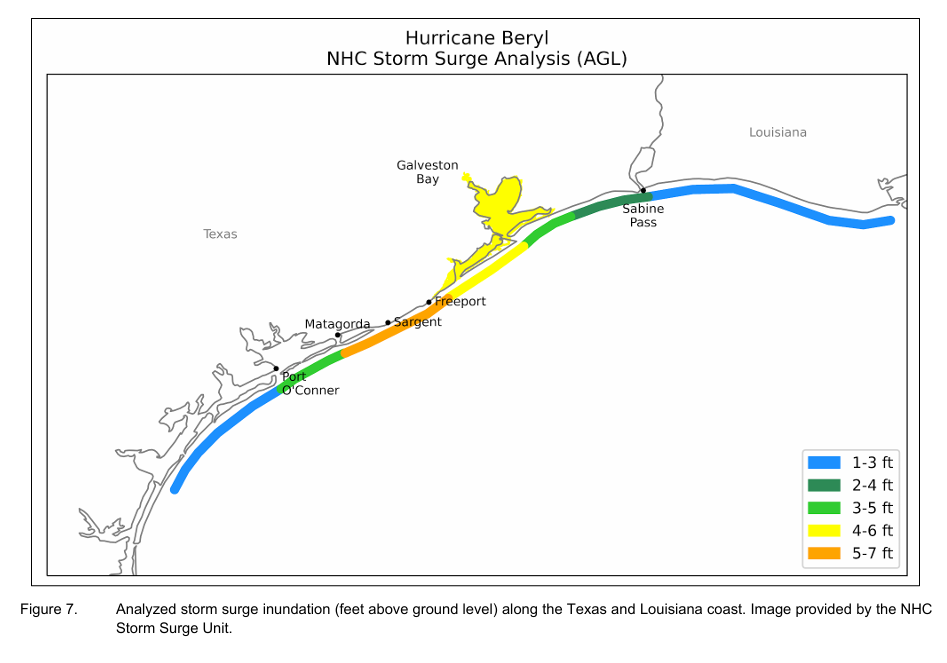
No surprises with rain or storm surge
Generally speaking, Beryl produced a surge height of 5 to 7 feet above ground level between Matagorda and Freeport. Much of this is based on high water mark assessments by teams following the storm. Surge values decreased to about 4 to 6 feet above ground level between Freeport and Galveston. Maximum rainfall was around 15 inches in Thompsons in Fort Bend County. That was an exception, as most locations generally saw 8 to 12 inches of rain.
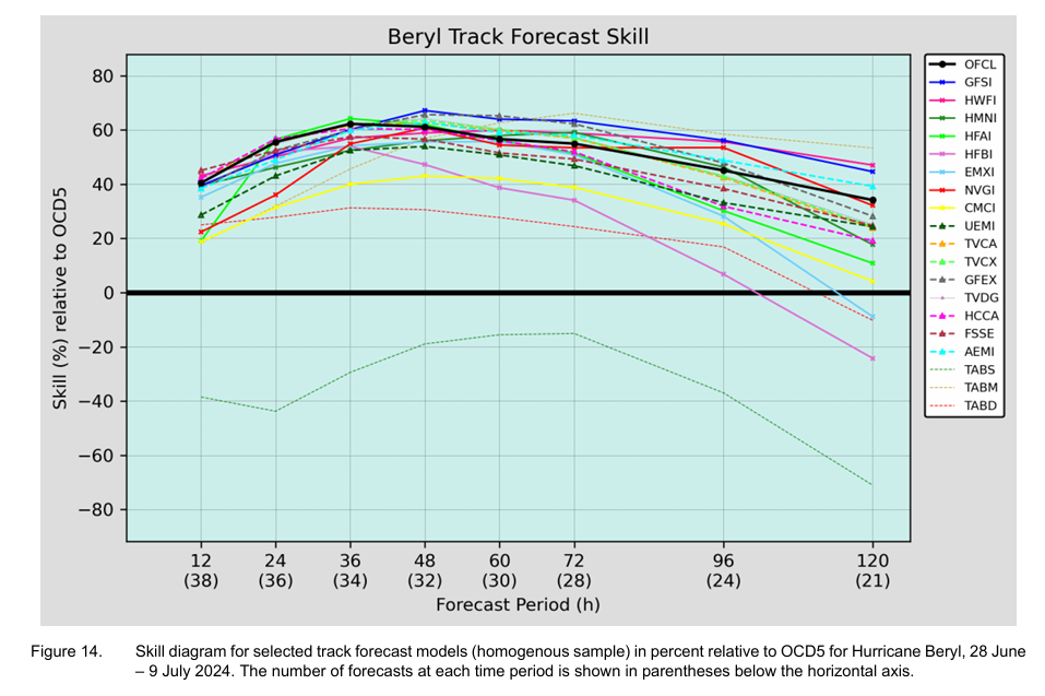
The forecast was excellent—except here
The NHC track forecast beat their average errors at almost all lead times on average through Beryl. A notable exception? When Beryl was in the western Caribbean and the majority of model guidance favored a Mexico landfall. From the report: “The largest track forecast errors occurred during the time that Beryl was moving through the western Caribbean when the forecasts for landfall on the western Gulf coast had a strong left or southward bias. Indeed, the Texas landfall position in the best track is at the right/northward edge of the official forecasts, and the forecast landfall points shifted significantly to the north as the storm approached the coast.” They go on to state that the TABM model (which basically just assumes a medium intensity storm) did best, whereas the ECMWF (Euro) and GFS (American) models failed. The reasons for the failure are not clear at this time.
Believe it or not, Beryl’s forecast track was really good on average — but the one exception occurred with the forecast of what it would do after the Yucatan, which is unfortunately what led to everyone scrambling to catch up over the holiday weekend last July. (NOAA NHC)
A glaring caveat to all this? They do not include the ICON or European AI model in track errors, which in my subjective view did best capturing the risks to Houston. One major change we implemented at Space City Weather was to give those models much more weight after Beryl, and they continued to perform well last season. Google’s AI GraphCast also did a very good job identifying the northward risks early on.
Beryl remains a warning to Houston
We’ve said this countless times in the wake of Beryl and since: It was a warning to this region. Beryl had 14 hours of favorable conditions over water to strengthen and went from a tropical storm to nearly a category 2 hurricane. What if it had 24 hours, and started from a 70 mph tropical storm? 36 hours? We’ve seen this play out in Florida, Louisiana, and the Coastal Bend several times since 2017 with storms in the Gulf of Mexico. Harvey, Michael, Ida, Ian, Idalia, Helene, Milton to name some others. It really is a matter of when, not if. We need to continue to focus on ensuring we’re prepared every year with our hurricane kits, getting more people to adopt that practice, and continuing to invest in resiliency and infrastructure improvements, which is to say: Build the damn Ike Dike.