Saharan dust just began to infiltrate the Houston area yesterday, and it was not yet thick enough to obscure the sunset, which proved to be a real treat in spots.
The sky is putting on quite a show in Aggieland this evening. @KBTXShel @BillyForney3 @NWSHouston pic.twitter.com/ce45ifzNGM
— Danny McConnell (@dannytamucc) June 26, 2020
Compare that to yesterday’s sunrise off the coast of Louisiana where dust was thicker.
Scene from the Mummy? Saharan Dust sunrise near the Mouth of the Mississippi. 📸Christopher Green @HankAllenWX @BrookeLaizer_Wx @NWSNewOrleans pic.twitter.com/5eH6ArvxRE
— Scot Pilié (@ScotPilie_Wx) June 25, 2020
Your sunrise and sunset mileage during dust events will certainly vary. Should the clouds clear, we expect thick dust today, but it may begin to disperse somewhat toward sunset, so there’s a chance we end up doing well. I think sunrise on Saturday may be fairly nice as well.
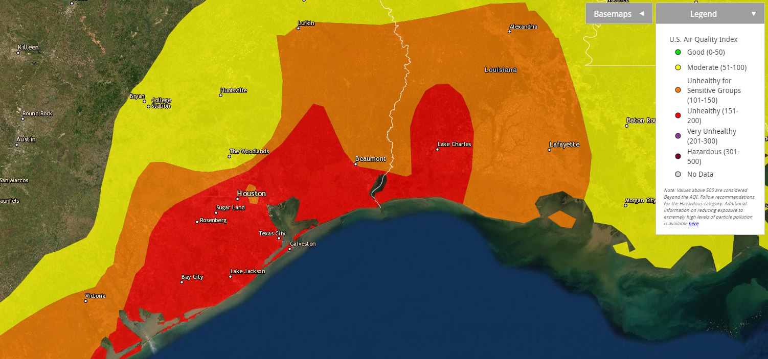
Aside from optical treats, there are practical issues with Saharan dust. The Texas Commission on Environmental Quality is forecasting today to be “unhealthy for sensitive groups” in the Houston area. Per the EPA air quality maps, we’re already one notch above that and “unhealthy” in much of the southeast half of the region.

If you have allergies, asthma, or other respiratory ailments, you will probably prefer to spend the better part of today indoors. Air quality should be improved a little bit tomorrow, though still probably considered poor. Sunday will be a little better than that.
As far as the rest of the weather goes….
Today
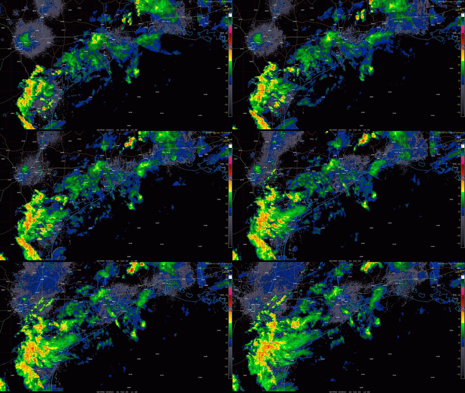
Radar is quiet for a change in the Houston area this morning, aside from a few light showers here and there. There are some storms north of Beaumont and some locally heavy rains in the Victoria area, with just nuisance showers in between.

Expect the heavier rains to our south and west to continue down there and lift northward today. This should keep those west of the Houston area and west of the hardest hit areas yesterday morning. While we could still see a few downpours or thunderstorms today, the focus will likely be between San Antonio and Columbus. If that should change, we’ll let you know. Yes, you might see some dust or “mud” residue on outside surfaces if it rains. Maybe. Rain would also help improve air quality.
With clouds, haze, or dust, don’t expect much in the way of true sunshine today. Highs will be in the 80s.
Weekend
Both Saturday and Sunday will feature a chance at a shower or thunderstorm. There may be a few small pockets where rain moves slowly and falls heavily for a time. So while many of us may not see much of anything this weekend, it’s not out of the question that a few neighborhoods end up with a couple inches of rain in a short time. I might give an edge to Sunday for having a higher rain chance, but both days will be setup for a few storms. Outside of that, expect a mix of clouds and sun with highs around 90, give or take a couple degrees and lows in the upper 70s.
Early next week
The overall weather pattern next week should be one where we gradually unwind this weak upper low over Texas and return to more of a typical weather scenario for late June or early July. Expect sunshine, some clouds, and at least a chance at a few afternoon showers or storms along the sea breeze as it rolls inland off the Gulf each day. Temps will top off in the low- to mid-90s each afternoon, with lows in the 70s.
Later next week
I’ll just set the table a bit here with a couple items to watch. The good news is that the tropics look quiet for us right now. I do think the Atlantic basin is going to turn more active beginning later next week, but that should not include the Gulf at this point. We will be resuming a weekly tropical outlook next week.
Saharan dust may surge back over the area by Wednesday or Thursday of next week, though we don’t believe it will be as significant as the current dust event will be. So hopefully slightly better air quality. There are some minor hints in modeling of a slightly stronger upper disturbance to bring a better chance of showers on Thursday or Friday, but that would be about all. We’ll have more next week!

It is a good thing we are all wearing masks when we leave the house anyways, so we will have one thing to filter the dust.
I think the dust might be a bit fine for a typical home-brew COVID mask. This stuff made it all the way from Africa, not from someone sneezing 4 feet from you 30 minutes ago.
This morning walk was dreadful between the 80+ degree temperature, near saturation humidity, and now the dust. And I’m not even in a sensitive population.
Super humid around here for sure. My home weather station says the current dewpoint is 81.
Definitely agree. This dust is small, only about 2.5 microns wide, and most homebrew cloth masks typically only filter down to 6-10 micron range. An N95 or P100 mask would catch these particles.
When I get back home, going to check the PM2.5 readings. Might be off scale.
With that description provided by Blackhawks Fan on walking outside, the Houston Chamber of Commerce won’t be calling him/her to write their next tourism campaign. Kidding!
Working from home, I haven’t driven my car since Sunday and only went outside to put out the trash midweek. On a bright note, hopefully all of these conditions will keep the temp down for a few more days. If there is rain, send it to the Hill County and Big Bend area to dampen things there.
Oh, did mention I’m leaving Houston In about two years for somewhere cooler with snow?
I cannot find anything about driving visialbility. My husband is driving to Houston from west TX today.
Visibility won’t be a problem.
Is the rain mitigating the dust in any way?
If it rained hard enough, yes. What we have right now won’t do much.
I’ve been sitting in my car for about an hour waiting on a barber, and the rain drops on the windshield definitely have dust in them.