Summary: We’re now in the worst part of this Arctic freeze, when we need to be cognizant of the very cold temperatures and wind chills, some remaining icy spots on roadways around Houston, and the Texas electricity grid. Fortunately the end is in sight, even if the next 24 hours look cold.
First, let’s discuss the forecast, then look at roads and the electricity grid.
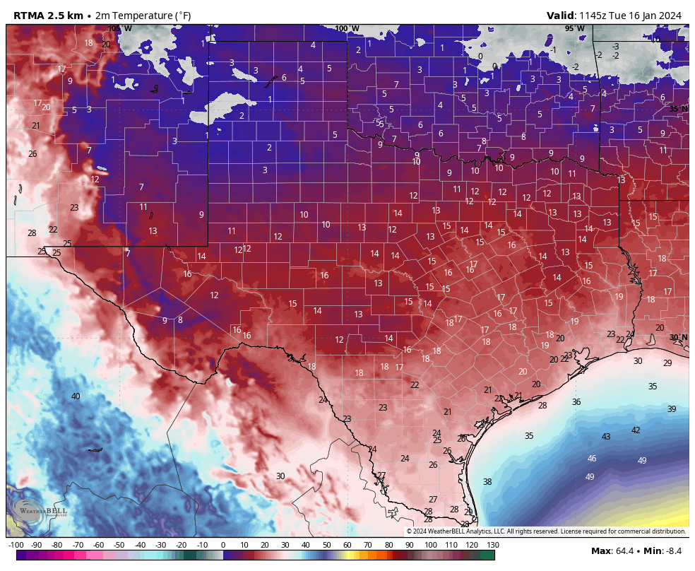
Tuesday
The temperature at Houston’s official station, Bush Intercontinental Airport, dropped to 19 degrees this morning (After publication, the temperature fell to 18 degrees at 6:50 am). This set a new record low for today. If you’re wondering how this temperature compares to the Valentine’s freeze in 2021, the lowest recorded temperature then was 12 degrees at Bush. (See lows during that freeze for a bunch of Southeast Texas locations here). When you layer on winds of 15 mph and higher gusts on to these temperatures, it feels like single-digit temperatures outside. That’s pretty brutal for Houston.
Winds will remain up this morning, but should subside some this afternoon finally. We’ll also see clearing skies this morning, which should help the temperatures some. Highs today in Houston should climb above freezing for a couple of hours, but their upper limit is likely mid-30s. Areas further inland, such as Katy and The Woodlands, may only briefly touch temperatures above freezing, or may not make it at all.
Low temperatures tonight should be similar to Monday night’s temperatures. The upside is that with significantly reduced winds, it will feel less cold outside.
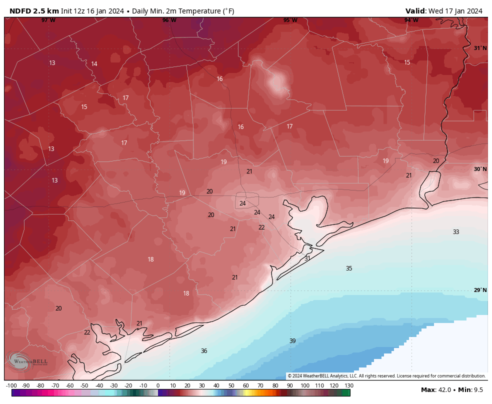
Wednesday
This will be another sunny day, but some clouds will start to build during the afternoon or evening hours. Temperatures will reach about 50 degrees, with lows only falling into the 40s.
Thursday
This day looks even warmer, if cloudy. Look for highs near 70 degrees. Alas, another cold front arrives later on Thursday to bring another round of rather cold air. Lows on Thursday night will drop to around 40 degrees in Houston, with slightly cooler conditions further inland.
Friday
Winter’s back, baby. Look for highs of around 50 degrees and a cold night. Expect temperatures to drop to around 30 degrees in Houston, so a light freeze is possible for the city. Inland areas may drop into the upper 20s. So maybe just keep your plants covered this week. This surge of colder air won’t be as sharp as the one we’re presently experiencing, but it still will be rather cold by Houston standards. Fortunately there is no precipitation in the forecast during the coldest periods.
Saturday, Sunday, and beyond
The weekend looks cold. Saturday should be mostly sunny with highs in the 40s. A light freeze will be possible for inland areas overnight. Sunday may reach 50 degrees or so with more cloud cover.
After this point we’re going to see a significant pattern change, although the details are still fuzzy. We’ll see warmer weather for awhile, with highs in the 60s or possibly low 70s for most of next week. We’re also going to see the return of some rain showers, possibly a few inches in accumulation starting on Sunday night or Monday. So after the cold, we’re going to get warmer and wet for awhile. I’ve been faithfully placing my orders for days in the 60s and 70s with lots of sunshine this winter, but y’all must be outvoting me.
Roadways
A lot of roads have dried out overnight with the winds. But icy patches remain on elevated freeways and exit ramps and bridges around the region. There are still quite a bit of closures, and travel is inadvisable until later this morning when sunshine and rising temperatures should help to dispatch the ice. You can track icy road locations at Houston Transtar’s website. After today there should be no concerns about winter-related mobility in the Houston area.
Electricity
As of 6:20 am CT, the Texas electricity grid is maintaining between 6,000 and 7,000 MW of excess capacity according to ERCOT. We’re expecting peak demand during the next couple of hours, but given the current capacity it seems that rolling blackouts are unlikely. After this morning, as most of Texas starts to warm up, the grid should have plenty of capacity to cover demand. So, crisis averted.


Should I make ice cream this evening by placing my kitchen aid outside on medium-low speed with the paddle attachment?
I prefer hot chocolate stranger
Thousands of people in NW Houston have had power outages off and on since about 1 am. At least 5 times sometimes
for an hour or 2 and sometimes for 15 minutes. I’m assuming these are rolling blackouts. Just wanted to mention that here.
No outages here in Magnolia (yet).
Most likely due to the wind
I’m in NW Houston; the outage we had (for about an hour) was due to a blown transformer.
Well, we’re at 16°f here in Magnolia. Looks like it’s scratching to get to 15°.
Isn’t it ironic that these are the exact days (dates) that we saw in the Feb 2021 freeze
Fingers crossed no probs on our property!👍
How is that? We’re in January.
They probably meant it was a Monday the 15th and Tuesday the 16th only in February last time.
Shout out to the NW side, we appreciate you.
The power grid is not ‘holding’. Just came out of a rolling blackout and some companies are closed today due to power concerns.
No you didn’t. TNMP and Centerpoint both say they have not started any rolling blackouts, and you can check this yourself. If you had an outage, it was the old fashioned kind, probably caused by ice on the transmission wires.
I’ve never had power restored in 20 minutes due to a natural event; and it’s never been an entire neighborhood. There is no ice anywhere in my neighborhood. Believe what you want…
I’m with you. Never had a “regular outage” last 1 hour to the minute and start exactly on the hour. 6:00am to 7:00 am.
People down the street from me are complaining on ND about no power, rest of the subdivision and surrounding ones are fine.
I wonder how our little friends in the mosquito “community” are doing?
They’re just dormant, will be back soon.
Well their cousins the ants are trying to get inside my house to get warm! LOL
Friendswood just bottomed out at 20F. A full 5 degrees colder than forecast by the NWS for our area. Which only verifies the fact that the GFS does have a warm bias when it comes to forecasting lows.
Some of the weather models apparently can’t believe that a mass of cold air pushing in from the north can ever prevent air from the Gulf warming things up near the coast.
So far GEM and ICON have been more accurate for the area … though Houston is in for some pain tonight if the reality is even close to what GEM predicts. If temps don’t get above freezing this afternoon, maybe its forecast of a low of 9F will look more plausible.
It is not going to be 9 degrees tonight. The GEM always way overestimates the cooling effect of clear, calm nights. It is much more of an outlier on such nights than on nights immediately after the passage of a front, like Sunday night.
It’s not really my original observation. It was pointed out to me by Eric Snodgrass who posts a daily video on Youtube. But my antedotal evidence kind of verifies it. Especially on cold, clear mornings…
Except that all the models showed substantial cold across the areas. Just that this particular airmass overperformed.
Note: temps as of this afternoon have already shot above freezing (NWS time series at IAH, Hobby, Sugar Land, Lake Jackson, etc). GEM had the ENTIRE AREA stuck in the mid 20s the entire day. GEM is cold-bias, it just happened that it was the “broken clock being right” for this particular morning.
Incorrect, UHI has an effect regardless of the level of cold.
The factor is generated by impervious covers + waste heat generation (i.e. even without cars, building heating and cooling systems still manifest).
Not to mention, UHI is most maximized on less windy, clearer nights (like we will be seeing tonight). If you look at conditions from last night/this morning, you’ll notice that they were accompanied by blowing winds … meaning that it was an “advective freeze” — that tends to have a more “uniform” temp spread that diminishes (if not outright eliminates) “microclimate effects (i.e. whether from UHI, bodies of water, elevation changes, etc).
GEM is cold biased. But ICON/NAM/HRRR might be a good call for tonight.
incorrect? there was evidence these past 2 days that the heat island effect does not make a difference in these temps…
Are you under the impression that GFS is the only model that NWS uses?
It seems the models underestimated things once again after yesterday’s mess. We were only supposed to get down to the mid 20s yet here we are at 18. Given that winds will subside and we’ll be set up for ideal cooling tonight, I’m worried we might reach the low 10s tonight..
Thank you SCW forvyour hard work!!
I agree with Glenn and Sean, the forecasts in this event, regardless of the source or media, seem to be 3-5 degrees higher than the actual. What’s different about this one?
It’s been like that for each of the arctic storms the last few years. The forecast always underestimates the lows. The models in use aren’t very accurate for this kind of thing. For next year’s arctic blast, just take 3-5 degrees off what the forecasts say will be the low for your area.
Isn’t it close enough? I mean how has the low being 3-5 degrees lower than expected significantly impacted anything?
If it was 5 degrees warmer yesterday, there would have been no ice, and we’d all be at school and work right now.
I guess I was thinking once below freezing what’s another few degrees, but I get your point.
It’d be nice if all winter we could just enjoy highs in the 50s and lows in the 40s without all these massive swings. Just when I get the right mix of blankets and cats on the bed sorted out for sleeping on cold nights we get these random 70 degree days that just confuse everything.
Still after the trauma 2023’s summer I’ll take whatever weather winter throws at me with a smile…
Water pressure is very low, probably the pipes are frozen, and this is a regular feature of the cold in Houston, from the forecasts I hadn’t expected it to be as cold as it was. Houston just wasn’t built for the cold, I do think that the ice age predicted during the 70s and 80s is beginning.
Water pressure is low from so many people running/trickling their taps.
A day of record low temps and you think an Ice Age is upon us? How far back does your memory go? Apparently not all the way to this past summer when we were knocking out heat records left and right lmao.
What I find interesting is that the county Institute of Forensic Science listed all of the heat related deaths, but never lists cold related deaths. Of course the cold kills more people. But cold weather doesn’t fit the narrative. I do remember the predictions of an ice age back in the 1900s. And when I first moved to Houston in the late 1900s, there was never extended freezing temperatures.
Seriously? You’re probably still having Jade Helm flashbacks. What “narrative” does the HCIFS have? Honestly?
These cold snaps are the result of a warming planet. A warmer Arctic means a weaker jet stream means more instances of freezing air masses able to escape containment and head south.
So if it gets cold it’s the result of a warming planet and if it gets hot it’s the result of a warming planet as well? Interesting outlook. Personally I think far too many people want to make this fit the narrative of their liking and not attributing it to what it really is. Natural climate variability.
And I am not denying the climate is changing and man is having an effect…
It’s not a narrative, it’s a statement of fact. Overall warming of the globe (global warming) can have effects on base atmospheric circulations such as to produce (or enhance the frequencies and forms of) variabilities like the cold snaps that have been hitting Texas/Southern US (climate change).
“Natural” is just a deflection. Even if it were true, that still represents a shift that impacts human civilization as we know it (and hence, spurns a need to mitigate/deal with the effects).
“Those bugs got INTO the house, and it’s the result of that broken window, but the cat got OUT of the house, and it’s also the result of that broken window? Interesting outlook.”
Hey Eric and Matt thank you for all you do keeping us well informed. Question—- why do you always reference Katy and The Woodlands and not Cypress? We Cypress residents feel left out 😢😂
Because Katy and TW would otherwise have image complexes if not mentioned. Cypress just hangs out and chills.
Yes, we do! 😑 Never a mention of our area. But, Eric and Matt, we Cypress residents are grateful for all you do.
At midnight last night, National Weather Service forecast low for my area was 23. The actual low was 18.1; it’s only 21.4 right now. Interestingly, last night Matt tweeted that he wouldn’t be surprised if temps would be lower because it was trying to clear–he should work for NWS. Matt and Eric are pretty clear when there is uncertainty in the forecast; in fact Eric used the word “guess” in one of the SCW titles a few days ago. That’s refreshing.
It wouldn’t have mattered even if it didn’t clear — winds were whipping throughout, meaning that it was an advective freeze.
Clearing is a factor regarding radiational freezes, which is what we will experience tonight. Calmer winds will allow any microclimates (waterside, UHI, etc) to reveal themselves.
It will be nice if we don’t have these ridiculous cold spells in Houston every other year. Can we go back to mild winter weather in Houston, please? Hopefully the roads will thaw out today, but right now it looks like the temperature is struggling to get out of 30 degrees.
Now THIS is a winter! Yeah, this is extreme is pretty dang cold, but after endless summers we’ve been enduring, I ain’t complaining
I come for the comments daily. This is a great community of HTX weather watchers who love to comment on the blog and other comments.
Today I spent an hour outside at 20F getting my darn TPS light to go out when I should have pumped up on Jan 10 when “BHawk” said to. Great advice. P follows T but I can confirm does not track the ideal gas law.
Thanks to “Anaconda”, I did not sweat the queen palms. As others have said the models are missing how cold it will go by 5 degf or more, even the day before. I shall remember this. The palms be wrecked… but this was indeed a big freeze. 33 hours and counting in the URBAN CORE and it does seem high teens are in our future. I don’t believe the worst is over.
And “Joseph” that same day gives his fine perspectives on the history of weather here. I’ve have learned over time that he’s got a lot of hard data. The freeze? ….this is normal
Yep I wouldn’t say that it is very common by any means, but throughout the recorded 135 years of data we have for this region it has happened many times. We typically go through intermittent periods were we will get harsh cold snaps like this. We had a big drop off in the frequency of arctic blasts that dropped us into the teens in the 90s and 2000s. Now we are entering a period where we are getting hit hard again by arctic airmasses frequently so, it appears that it is something new and unheard of because it simply hasn’t happen much since the 80s.
I definitely remember plenty of frigid winter days around here back in the ’70s and ’80s, with December of 1989 being of particular note. Growing up, that’s what I always expected Texas Gulf Coast winters to be like, so was disappointed when they started becoming milder in the ’90s and 2000s.
My family and friends have come to depend on the Space City Weather’s complete and accurate forecasting!!
Can we get a realistic worst case low for Houston proper tonight? These forecasted lows have been way off last 2 days.
9F is the lowest prediction for Houston I’ve seen, coming from the GEM model. GEM and ICON have been the most accurate so far for the area, though ICON “only” shows it getting down to 21F. My random guess would be that it’s somewhere between those two.
Nah, CMC is a cold-bias model — it just so “happened” to be accurate in overperforming arctic blast.
Temps across SE Texas now are in the 30s … whereas CMC kept the area no higher than mid 20s. Lows tonight will be closer to ICON/NAM/HRRR. So similar to last night, but should have more “microclimate effects” (i.e. water, any UHI generated, etc).
SCW – can y’all address the Canadian model forecast and its applicability (or not) to our situation? It seemed to line up better with what happened Tuesday morning but I’m not sure if that’s a coincidence or something to do with the unexpected clearing. Thanks so much!
It was 18 with a windchil of 7 in Sweeny. This is the 3rd time in the 2020s that it has dropped into the teens in this region. It seems like we have reverted back to the way it was back in the 70s and 80s where we had harsh arctic blasts almost every winter.
Totally agree with you, this is nothing new to this area.
34 degrees and sunny at 13:50 today in the Westchase area.
Topped out at 37.
Weather is not something we can change in the moment. It’s going to be what it is. Thank you, Eric and Matt, for doing your best within the parameters, experience, and astute observations over the years to let others know what we might expect to experience where we live. I appreciate you serving up your best in the constantly changing science of meteorology.