Summary: Temperatures have trended a bit cooler than expected today, with the freezing line extending all the way down to near the coast. This has caused more problems on area roadways. Elevated highways and bridges, especially, should be treated with caution this evening, and overnight. Tomorrow morning will also feature very cold wind chills, so staying home is advisable, if possible.
Monday night roads
We missed the temperature forecast today by a couple of degrees, but those degrees mattered and led to freezing conditions for most of Houston. With just a couple of hours of daylight left, temperatures are not going up today. Accordingly the freeze line has moved far enough down through the metro are that the light precipitation we’ve been seeing today has caused issues on roadways, particularly bridges and overpasses. This is understandably leading to mobility problems around Houston.
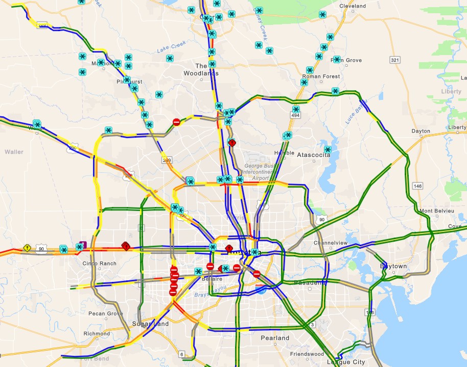
In particular, an accident on icy roads at Interstate 10 and FM 359 in Brookshire, to the west of Katy, shut down the freeway this morning. With the earlier onset of freezing temperatures in the metro area it is clear that drivers need to take care if they’re going to be out and about today and this evening, especially for areas along and inland of US 59/Interstate 69. Travel northwest of Houston, toward College Station; and north toward Dallas is inadvisable (see icy conditions map).
This light precipitation will clear out of the area later this afternoon and evening, but with a hard freeze setting in—and already there over inland areas where there are already some ice accumulations—it will take some time for the ice to sublimate. How long? That will depend on how much ice there is presently on road surfaces, the effectiveness of de-icing by transportation officials, and sunshine on Tuesday morning. The bottom line is that roads will be potentially hazardous for the rest of today, likely overnight, and possibly into Tuesday morning.
Monday night temperatures
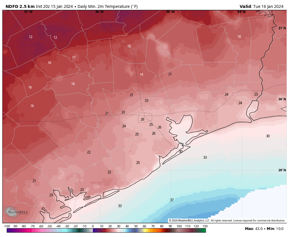
We should see cloud cover for most of tonight, which will help keep temperatures from bottoming out too hard. Winds will be another factor. Paradoxically, winds elevate air temperatures through mixing; but make apparent temperatures feel colder. Accordingly, lows tonight will drop roughly into the mid-20s in the urban core of Houston, with colder conditions expected for outlying areas.
When you tack on gusty winds, up to 20 or 25 mph through the night and into Tuesday morning, it’s going to easily feel like the teens out there. That is not cold to be easily dismissed, and it’s understandable that some school districts have already canceled schools due to the combination of potentially icy roads and very cold wind chills.
Power conservation
ERCOT has issued another call for electricity conservation on Tuesday morning, during the hours of 6 am to 9 am, due to cold temperatures statewide and surging power demand. The current forecast for electricity shows demand forecast to be higher than supplies during this time frame, so it is possible that we see some rolling blackouts for a couple of hours. It’s something we’ll all be monitoring early tomorrow morning, I am sure.
Tuesday and Tuesday night
At some point on Tuesday morning the skies will clear, and we’re going to see the sunshine. This should help sublimate any remaining ice on the roads in the Houston metro area, even though air temperatures are likely to remain below freezing during the morning hours. Parts of the city near downtown and closer to the coast will briefly climb above freezing on Tuesday. But we’ll cool down quickly as winds die down, and with clear skies overnight. Expect low temperatures to be a couple of degrees colder than Monday night.
By Wednesday morning we’ll be warming nicely, with sunny skies, to daytime highs of about 50 degrees.
A message from Reliant
We’re grateful for Eric and Matt’s dedication to keeping us informed during this wintery weather. When it comes to energy usage during extreme weather, Reliant also wants to help Texans be prepared. With temperatures dipping, Texans may crank up their heaters to stay warm and because many have electric heaters, freezing temperatures could result in increased energy usage and costs. Heating the home can use up to five times more electricity in one hour than the AC does in the summer.
Through a few simple actions, Reliant is arming Space City Weather readers (regardless of their electricity provider) with tips to help save energy while staying warm:
- Check your thermostat. If you have electric heat in your home, keeping your thermostat around 68 degrees can help you save energy. For every degree above that, you can typically expect a 3-5% increase in heating costs.
- Let the sun in. When the sun is shining, open blinds and shades during the day to naturally warm your home. Close them at night to help block out the chill.
- Close heat escape routes. Keep the chimney damper closed when not in use and be mindful of how often you’re opening entry doors and using bathroom or utility room ventilation fans, as heat can escape through these outlets.
- Set your ceiling fan to rotateclockwise. This helps force warm air down from the ceiling into the room to create a more comfortable environment.
For more tips on staying warm while managing your energy usage, visit Reliant.com/WinterTips.


Remind him to take his dog to Cancun this time!
I went to Florida during the snowpocalypse. I ain’t mad at him
You’re not an elected “leader”
I know a lot of industry has shut down for freeze protection, I don’t understand how ERCOT still needs individuals to conserve power, all of those plants going down should have freed up a lot of the power demand. Interesting.
I would guess with more people staying home from work and school that there would be a higher demand for electricity with these low temps. An office building heated to keep 100 people warm that gets closed vs 100 people now working from home accounts for 100 houses that need electrical heat and lights, for example. Just a guess it’s not a 1:1 demand.
Phew! And a new word for at least a few of us… Sublimate. As in cause to pass directly from the solid to the vapor state. Correct? Personally I am staying solidly parked in the upstairs rooms where it is warmest… Thanks for your great coverage.
Happy that I knew what sublimate was do to the crafting.
Sublimate: v. OED; 2. transform into a purer or more idealized form. As in, Matt is now sublimated. 😉
Thank you from all of us for ERIC & MATT Space City Weather forecasting. They give us a much better look at all the different communities weather outlook instead of a blanket report trying to cover all the area. I watch for their posts every day and no such thing as a 100% accuracy on meteorology I know though these guys know Houston and they’re really good at getting the word out.
Just think that 4 to 5 months ago we were stuck under relentless extreme heat. I wonder what people would prefer the excessive triple digit heat last summer or this extreme cold?
Cold for me. You can always put on more clothes. With the heat, you can only take off so much…
disagree, no matter how many clothes I put on Im still cold and I hate wearing so many clothes. So… heat is better
Cold as well, and I’ve always made the same comment about being able to put more on compared to how much you can take off. Also, this is Houston, theis cold is only going to last a few days, not 4 or 5 months with no relief.
Cold! No humidty, no dripping sweat, no mosquitos, no threat of hurricane, feels crisp and not like an armpit outside all the time! I can put on blankets, fireplace and be so cozy. When I’m hot im miserable.
Can the grid go down, causing my pipes to freeze and costing me $10k worth of repairs in the summer?
HEAT ALL DAY EVERYDAY!!!
hot weather for me for sure… I dont have to be shutting down my water in the summer heat or insulating things much less worrying about losing power and dying of hypothermia. We are in the south, heat is a given. This cold mess is not something the city is prepared for. Plus I spend a lot of time outdoors and I actually work. So, heat is not the best but better than this.
cold is a given in Texas as well
Cold…all year!
Prefer heat. No fear of frozen water pipes or power outages in sub freezing temps. Ice on roadway, etc
What an awesome tip from SCW regarding using ceiling fans clockwise to bring down warm air. It works great for us old folks under a blanket.
I will gladly take the heat, don’t have to worry about freezing roads and flyovers, power outages, pipes freezing and breaking and the list goes on. Thanks for all the updates and keeping the forecast real and without all the hype, greatly appreciated
I personally prefer the cold just without the icy roads.
Don’t mean to be overly critical, but you missed the temperature prediction by at least 5 degrees. That is disappointing and not what I am used to from you guys. You’re also saying we may have rolling blackouts Tuesday morning. That was not supposed to happen either. Don’t know what to believe any more. Apple’s weather app blew it also.
weather prediction is never perfect Jack and rolling blackouts was always a consideration for Tuesday given the temps predicted to be fir that day
I agree but it really is not their fault. ALL the models have been wrong, the European, American, etc. None of them were able to forecast this mess and I have a feeling it is going to get worse. Temperatures are already dropping and it is not even dark as Im typing this. You just cant trust anyone but be prepared. I shut down the water at my house because all this “drip your faucets” is pointless with temperatures this low and these many hours below freezing. These events were supposed to happen every 30 years and now they are happening every winter. I think all meteorologists and experts need to reconsider low temperature forecasts and models need to be tweeked and updated to take in consideration other factors that are making these extreme changes. That’s the beauty of technology, always has room for improvement. If you dont even try then we would be stuck in the Ice age. No pun intended.
Not true. ICON and GEM have been much closer thus far. It’s GFS and ECMWF that can’t handle cold air hitting that far south, especially near the coast.
Went outside at about 2 pm today in 4th Ward, and saw fine snowflakes mixed in with the drizzle!
Overly critical Jack needs to tell us how much he paid for exactness. What a whiner…
I dont think it is about whining, it is a call to improve forecasts which need a serious reconsideration in how they are being put out there. If I had known the mess it was gonna be with the frozen streets, I woudlnt have gone to work. Was stuck on the roads for hours and my house heater just gave up because it was on so many hours… now my pipes are at risk so I shut down the water but it took me forever to get home. It was all unplanned and inconvenient because I also trusted the forecasts of not freezing today.
And I’ll say it again please for the love of God bring the pets indoors.
For sure. My cat loves being outside. He lives out side most of the year. The first night he came in and slept all night. Now he’s up and wants out. Had to drag him him back inside and give him snacks. I was out there for 15 minutes and I grew up in this. Make your pets happy and safe.
I understand it’s all just predictions but I left work early with my car covered in ice after all predictions said no freeze till tonight. I heard (not here) fred Hartman bridge would likely be icy. As of now does not appear it ever was nor was ship channel bridge. If anyone has any idea whats going on in those areas please share because everyone is just focused on katy and the woodlands it seems
Not at all surprised by the wreck on I-10 at 359 shutting down the freeway, seems it’s, at minimum, a weekly occurrence, and probably would have happened even without the ice.
Prediction for us up in Magnolia … we should experience 16° to 18° Tue night thru Wed morning :/
If you have to be out and about tonight/on Tuesday or Wednesday, bang on your hood and look under your car before you start the engine and move it. Wildlife and other animals seek out any shelter they can find and parked cars are often considered safe havens.
Truth be told, the bigger risk to pipes and infrastructure will be tonight rather than tomorrow night, even though tomorrow will be colder, due to the wind. The ground and structures will still be above freezing and radiate heat, but the wind serves to whisk that heat away and bring colder air where it wouldn’t be absent the winds