In brief: Yes, you are not crazy. Monday did feel incredibly hot outside, and the smoky haze from agricultural fires in Central America did not help. We’re now going to see a pattern change that could bring storms into the metro area as early as this afternoon. Today will be a day to be weather aware and we’ll update the site again by around noon.
Memorial Day madness
Houston did not set record high temperatures on Monday. The official high at Bush Intercontinental was 96 degrees, two degrees shy of the all time high of 98 degrees for May 27. However, it felt extremely warm thanks to incredibly high dewpoints. For example, at Houston’s Hobby Airport the heat index reached 115 degrees. This is a combination of temperature and relative humidity.
Even if you don’t have context for how hot that is—and believe me, it’s hot—Houston has never had a heat index of 115 degrees in May before. Moreover, Hobby Airport did not have a heat index that warm during all of last summer, which was excruciatingly hot. You’ve got to go all the way back to August of 1998 for a reading that high. Last summer recorded much hotter temperatures, but the humidity was somewhat lower, in part due to drought-like conditions. Fortunately, we’re now going to step back from the abyss of extreme heat for awhile.
Tuesday
Today will not be nearly so hot. Partly cloudy skies will help to moderate temperatures a bit, although we are still likely to see highs in the low 90s with plenty of humidity. The difficult question is severe weather potential, with the possibility of storms this afternoon, and then again overnight. As of 6:30 am CT there was a cluster of storms near Dallas, moving southward. The question is what happens to this system, and whether it holds together long enough to affect the Houston area. There has been a lack of consistency in our guidance.
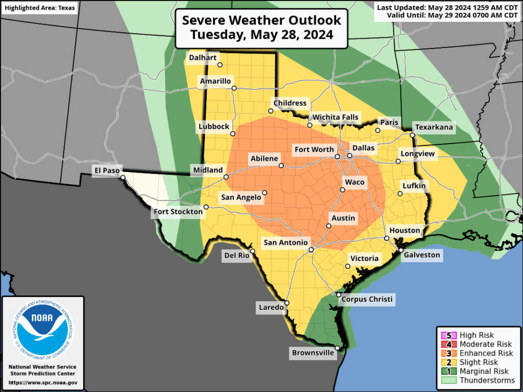
Right now my sense is that this system will hold together as it approaches our northern areas, such as Conroe and College Station, shortly after noon. Then we could see this line of severe weather move from north to south, with strong thunderstorms, wind, and hail pushing into Houston during the afternoon hours. It could reach the coast by 4 or 5 pm. The usual severe storm risks are there, with heavy rainfall, damaging, winds, hail, and possibly a few tornadoes. We will update the site by around noon when we have more confidence in this forecast.
Then there is the potential for a second round of storms tonight after midnight. However, this is probably conditional on what happens this afternoon. I.e. if we get a fairly pronounced line of storms this afternoon, things will be quieter tonight. But if storms peter out later today before reaching Houston, a more pronounced line of storms could pass through tonight.
Wednesday and Thursday
These should be a pair of partly to mostly cloudy days, which will help limit highs to the upper 80s. Each day will also see a healthy chance of showers, although the likelihood of severe weather appears to be considerably lower. Nights will be warm, in the upper 70s.
Friday, Saturday, and Sunday
The end of the week and the weekend look slightly warmer, with daily highs of around 90 degrees and partly sunny days. The atmosphere will remain somewhat unsettled, but daily rain chances will drop to perhaps 30 percent, so if you have outdoor plans this weekend I don’t see anything like a total washout at this point. Let’s see how the forecast evolves.

Is there any sense of when we’ll see the haze lift from the fires? My daughters and I are all asthmatic and would love to.know when we’ll see better days.
I was wondering about the haze! It felt like we were in a fog at 2 in the afternoon.
I knew we weren’t going to get anywhere close to 100 yesterday, but that heat index was awful. Was sitting in the shade with absolutely no breeze around 2 PM watching my kids play in the splash pad, and was wiping the off sweat every 30 seconds. Just glad it was short lived.
Does the weather this afternoon have the potential to as bad as May 16?
They had a crazy hail storm in central Mexico this weekend. Their streets looked like NY or something, 1.7 feet of hail packed down, 30 minutes of hail fell. They were shoveling out from it. Extreme heat, then an ice storm. How in the hail did that happen?
Crazy is the only word.
Since when is May is scarier than hurricane season?
But Climate change ain’t real
Not denying but you realize we had heat like this back in the early 1900’s long before any man made sources altered the climate. There are powerful natural cycles.
Except there is research data showing climate change was occuring as early as the 1900’s
The science would say it was happening much earlier than the 1900s.
Here we go again. Round 2. I cannot wait to move. I am so sick of this heat and these stupid storms that damage my house every time!!!
Ain’t life grand! Can’t take the heat get outta the kitchen.
We moved to the upper midwest last year and I have to say I don’t regret it one bit… Being here for a visit this week has made me realize what a great choice we made for us… We just are not people that like sweltering heat. We like to be outdoors and do things and so this is a terrible place to live if you like that sort of thing.
I can tell you with absolute certainty that not every storm we get will have a derecho attached.
Probably headed to the mid-South myself.
Is there a source to see historical heat index data…and specifically heat index numbers for 2023?
The only way I can find historical heat index values is to go to Wunderground.com and type in the city you want then click on history. You can view daily and hourly history with temperatures, humidity, and dew points. You can look at daily and hourly data from Houston Hobby airport going back to the late 1940s. To get the heat index you just have to go search for a heat index calculator and plug in the air temp and dew points to see what the heat index was on a specific day 50+ years ago. There may be a better way to find historical heat index data I just haven’t found it yet. I wish I could post links on here but I can’t.
Were off to a warm start with 10 days in May above 90F. But I am still thinking this summer is going to be just hot and humid and not the blowtorch we had last year. Fewer than 8 days above 100…
Once again I’m basing this forecast on nothing other than a whim and certainly not on any scientific evidence…
I like your optimism
Getting tired of all the rain from this drought
I’m really glad that my landlord decided that the tree that got slightly uprooted a bit after the last storm should not have anything done to it…
True, well done for him. We need THAT tree! 🙂
It’s one of the only trees left in the back yard… fortunately, thanks to the last storm, it’s now leaning slightly towards our bedroom. Just a great decision from him. Truly the best decision ever made. Fingers crossed that it makes it through the forthcoming 80mph winds.
“ it’s hot—Houston has never had a heat index of 115 degrees in May before.” You know you don’t have the kind of data to support such a claim. Come on guys, let’s leave the drama out of it.
You should start your own weather related site since you have the answer about historical heat indexes than meteorologists who study this for a living
Heat index values started being used in 1979. We can extrapolate before this period but there is no definitive heat index numbers prior to 1979.
There is nothing wrong with calling these guys out once in a while!
Is it reasonable to ‘call out’ people who give you free information?
What kind of a weather pattern is generating these strong straight line winds? I know we’ve had occasional tornado outbreaks in the past, but derechos on repeat feels like an unprecedented thing. “Climate change” may be the quick answer, but I’m asking about the specifics of the pattern that keeps generating these storms. Does the wildfire smoke from down south have anything to do with seeding the clouds?
did houston experience another derecho that I don’t know about?
This May and last June we had northwesterly flow aloft with a heat dome high pressure to our south. This pattern is what often brings derechos to the Midwest in the summer: being on the north side of a heat dome. Instead of storms forming with the sea breeze or moving in from the northeast with a dying front, the storms form west of us and move quickly around the high.
(also, instead of storms forming from a stalled upper level low west of us, as often happens in late spring. Such storms would be unlikely to form into a derecho, since they would probably be moving more slowly. We haven’t really had such a pattern yet this year.)
You guys said we were done with spring storms.
yea they did. you do know weather forcasting can be tricky right, just go with the flow, you’ll be fine.
Patiently waiting for the noon update…
Same Here. Though I’m being extra paranoid because of the Derecho.