Houston continues to face the prospect of a wet Labor Day Weekend—but we’re not concerned about anything more than the potential for some street flooding and spoiled outdoor barbecues with intermittent showers and thunderstorms.
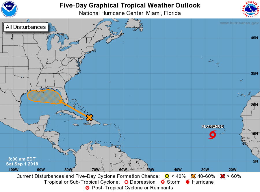
However, we did want to update you on the potential for tropical mischief in the Gulf of Mexico next week. Some forecast models have become a little more bullish on low pressure forming in the northern Gulf next week, which could lead to development of a tropical storm. As of Saturday morning, the National Hurricane Center predicts a 40 percent chance that a tropical depression or storm will form during the next five days.

There are a lot of uncertainties with this system, and forecast models are having a difficult time resolving them. Of course, everyone will want to know where this will go. However, that’s simply impossible to say without a reasonably well defined low pressure system, and that probably won’t exist for a couple of days.
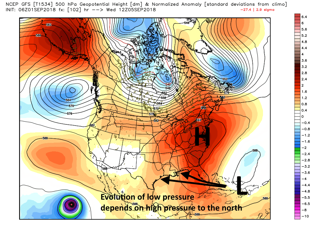
Overall I think there are probably two main scenarios, and which one happens depends upon the strength of a high pressure system over the eastern United States.
Scenario One: The tropical system holds to a more or less west-northwest movement through the middle of next week, as high pressure over the eastern United States does not block some northward movement. This brings the bulk of the tropical moisture more toward Louisiana than Texas, and most likely a tropical storm does not form.
Scenario Two: With stronger high pressure, the system is forced nearly due west once it reaches the northern Gulf of Mexico. In this case, with more time over water, the tropical system has the potential to become a tropical depression or perhaps a storm as it moves toward the Texas coast late next week. In this case the Houston region could see some significant rainfall, but at this point the likelihood of anything extreme (i.e. 10 inches or more in a couple of days) seems fairly low.

In any case, we always want to watch tropical weather in the Gulf of Mexico, during September, carefully. And so Matt and I will do just that.

Eric, thank you for the update and the objective, matter of fact updates.
Thanks for the update! Always a great source of hype-free forecasting!
…uh, I mean “and the matter of fact discussion”.
Thanks guys. Enjoy your holiday
As someone who weathered life-changing events in Hurricane Katrina before relocating to Houston, I find great reassurance in your forthright, hype-free insights and analysis. Your service is indispensable to me… thanks for being a voice of reason and experience!
Thank you for facts that help us. Thankyou for using science to
keep us informed
I don’t like this last paragraph from the NWS discussion this morning, so I’m going outside to clear out the french drains:
“Concerns though that the area of low pressure lingering in the NW
Gulf overnight/Sunday with dry air being replaced by the large
moisture plume over MS/FL and the Eastern Gulf. This has some
potential to increase threat of heavy rainfall Sunday and Monday.
Stay tuned.”
Love the handle, There Ain’t no such thing as a free lunch. Used to be a restaurant in Midland, TX with that name
I see a Euro 10 day forecast for cumulative rainfall and it has some very alarming rain totals in a triangle of Sugar Land, Bay City and Lake Jackson approaching 27″. Of course it is a 10 day forecast and just one forecasts. Thoughts?
Can you point me to the model URL
Thanks
I am traveling to the Caribbean late next week for vacation for about a week. Getting a little worried about traveling there this week with the disturbance in the gulf and getting home with the expected storms after Florence. Should I be concerned at all about my travel?
As always, very much appreciate the straightforward weather analysis provided on a daily basis. Thanks!
Not suppose to have any hurricanes, due to the three SAHARA DESERT DUST STORMS we’ve experienced this summer!!!!’😬😬😬