In regard to rainfall and the Houston metro area, we have two separate issues to discuss. There is the potential for heavy rainfall on Sunday, Monday, and Tuesday; and then the renewed potential for heavy rain toward next weekend, as a tropical disturbance—perhaps Tropical Storm Gordon—brings rainfall to the northern Gulf of Mexico coast.
Labor Day Weekend
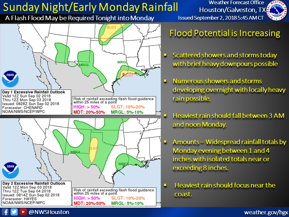
A weak low pressure system over southern Louisiana and the northern Gulf of Mexico will drift westward over the next few days, bringing an excellent chance of rain to the Houston metro area on Sunday, Monday, and Tuesday. The National Weather Service will issue a “Flash Flood Watch,” and there is a general expectation of 1 to 4 inches of rainfall, with isolated areas seeing as much as 8 inches. The best chance for heavy rainfall will come on Sunday night, and throughout Labor Day. If you have travel plans on Monday, please to check conditions before venturing out. For the most part we expect street flooding, but can’t rule out some more serious effects in areas where the storms establish themselves and don’t really move.
We have reasonable confidence that after this system clears the area, we should see somewhat drier conditions on Wednesday and Thursday for Houston, with partly sunny skies and more scattered showers. Which is a good thing, because …

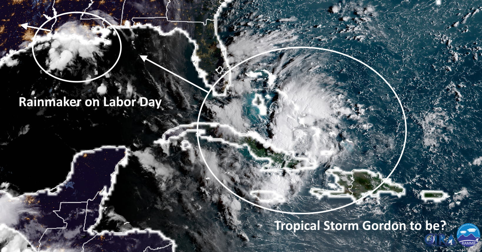
Gulf disturbance
As of 7am CT Sunday, the National Hurricane Center has elevated the chance for development of a tropical depression or storm in the Gulf of Mexico over the next 5 days to 80 percent.
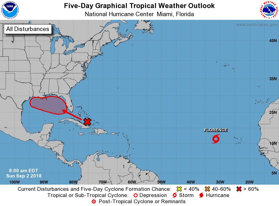
Confidence is increasing that this system will move into the eastern Gulf of Mexico, and then likely become Tropical Storm Gordon as it tracks northwest. Most likely, it seems bound for Louisiana, so initially (Wednesday and Thursday time frame), Texas should be on the drier side of the storm. There is little indication—at this time, at least—that Gordon would become a hurricane. The primary threat from this system therefore appears to be rainfall. (Note that we can’t entirely rule out Gordon staying offshore, and moving more toward Texas, next week. But that seems a fairly low probability for now).
By Friday or so of next week, it seems most likely that the remnants of this tropical disturbance will track toward Texas, and regardless of whether the center is inland it could still prove a potent rainmaker. It is too early to predict rainfall amounts with any confidence, but next weekend again looks wet in Houston, with possibilities ranging anywhere from 1-2 inches of widespread rain up to 8-10 inches. For now, it’s just not possible to say.
The important things to know right now:
- Heavy rainfall threat in Houston Sunday night and Labor Day
- Tropical Storm Gordon may form in the Gulf next week, and move toward Louisiana
- The remnants of Gordon may bring more heavy rainfall next weekend to Houston
- There is plenty of uncertainty about Gordon to have much confidence in its Texas effects
Oh boy… my students are gonna have panic attacks if they hear about this. Most of them got flooding in 2 outta the last 3 floods. Heavy rain really makes them nervous now. Thanks for the heads up so I can help soothe fears when I see them Tues.!
Right now there is no reason to expect a major flooding event. We can’t rule it out, but overall 8-10 inches of rain over the next week is more than manageable for nearly all of Houston.
Build higher houses that don’t flood.
When was the last holiday Houston didn’t flood?
This weekend is Labor Day, next weekend is Rosh Hashanah. I starting to not look forward to Holidays.
Thanks for being the edge of reason. Other blogs would rather have doom casting than look at an array of facts.
Thank you Eric! So glad to have your analysis!
Didn’t we say something about NOT having it all it once? I know it could be worse, but I think the entire city has a panic attack at the same time when we see the words “heavy rain possible.” Also, happy 10th anniversary Hurricane Ike! UGH. Can it not storm on my nephew’s birthday every year?
Eric, thanks for summing everything up in bullet points at the very end of your multi-topic posts. I personally find that reiteration helpful.
Thanks for the feedback!
I have been following you since a friend told us about your blog last August. You do a great job and we are truly grateful for your insights and guidance regarding weather and what to expect!! Thank you so much!
You’re quite welcome.
Eric or Matt, how’s it looking for those of us NW of Houston, ie: Brenham area? We need rain so badly!
You’re going to get some. Best guess would be 2-6 inches over the next week.
Thanks Eric, for working the holiday weekend.
So, isolated 8 inches today and tomorrow…. with time to drain away before next weekend.
We can manage that.
Hi Eric
Can you post the link for the rain forcast models, which one in your opinion is the most accurate or which do you use.
Thanks for everything
None of the models are particularly accurate. These are official NOAA estimates, and they’re probably the best.
https://www.wpc.ncep.noaa.gov/qpf/day1-7.shtml
Thank you Sir
Well, at least all the local news reporters will have no trouble finding a water filled ditch to stand in for their reporting of this non event.
This labor day mess reminds me of Allison. Hope it dissipates and moves on
Remember Hurricane Ike hitting us in September? Concerns are how many inches of rain will we have in Houston in view of poor drainage and the bayous that lost their depth and got so much debris during Harvey.
Just a thank you for the excellent service you provide.
Any estimates of effects to NorthEast Pearland Area
So, basically, it’s going to be wet, really wet or really, really wet this week?
Since the Chronicle days you have brought a sense of calm to my weather anxieties (childhood tornado experience) And yes, the end summeries are the best
If we are supposed to be driving back from South Padre tomorrow into Houston… would you recommend an early morning start, or leaving later in the day?
Thank you for your straightforwardness. Have so much more faith in you than all our local weathermen.!!
Thank you, as always, for your excellent weather reporting. You are who I trust and follow.
I have followed your column for quite some time and appreciate reading the easy to read scientific forecasts. When I want truthful, straightforward facts I know where to turn. Thanks, Eric, for being there!
Glad to be of service.