As Eric covered this morning, we’re watching rain chances here in the Houston area for the midweek period, as some rainfall rates may lead to street flooding in parts of the area, especially north of I-10. But we wanted to also catch you up on what’s happening elsewhere in Texas, as we know many of you travel to and fro or have friends and relatives across the Lone Star State. Here’s a quick rundown of what’s happened and what to expect.
DFW Metroplex flooded
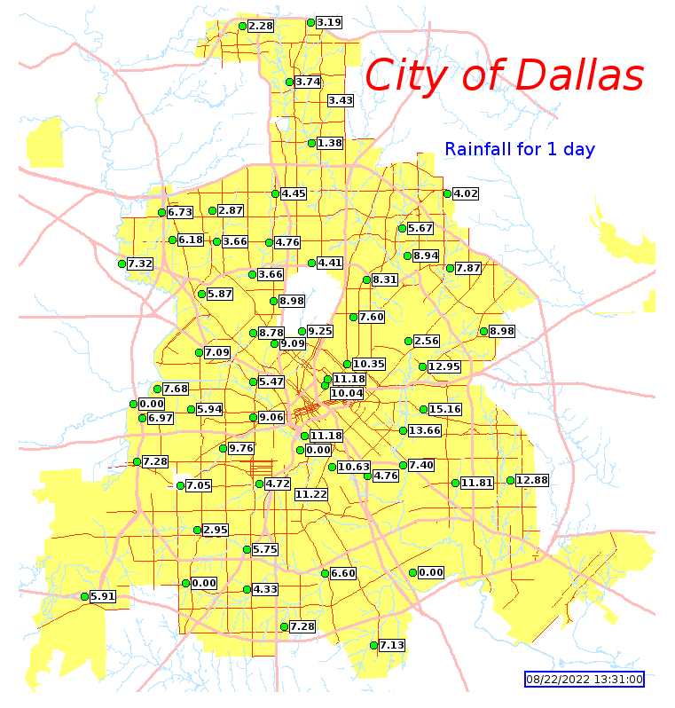
Incredible amounts of rain fell on the Dallas and Fort Worth Metroplex overnight and into today, with some parts of Dallas and Tarrant Counties seeing 12 to 16 inches of rain in 24 hours. DFW Airport is approaching its single day rainfall record, and at worst it will finish as the second wettest day there on record.
Many roadways are flooded, and if they aren’t, they are littered with flooded cars. Travel is discouraged to Dallas or Fort Worth the rest of today. Tomorrow seems like a better day for that, though you may encounter heavy rainfall between Houston and Dallas. So whatever your plans are, please use caution and budget in patience and pad.
City of Dallas rain total map
Tarrant County rain total map
Next round of flooding concerns
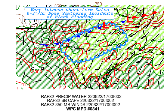
For folks in Dallas, the good news is that rain should ease up a lot this evening as the frontal boundary that has helped focus the rains has sagged south of the city. They will have a chance to clean up. Rainfall should begin to pick up in intensity a bit farther south though, and tonight’s focus could be Hill Country or the San Antonio and Austin areas.
In fact, Hill Country and parts of San Antonio, Austin, and Waco are being highlighted by the National Weather Service Weather Prediction Center (WPC) this afternoon for potential 2 to 3 inch hourly rainfall rates.
In addition to this, areas of northeast Texas may be targeted with heavy rainfall as well, and the flooding threat will extend to places like Texarkana and Tyler. Tyler is under a Flash Flood Warning as of this writing. Flood Watches include those locations, down to Lufkin and east past Shreveport, LA.
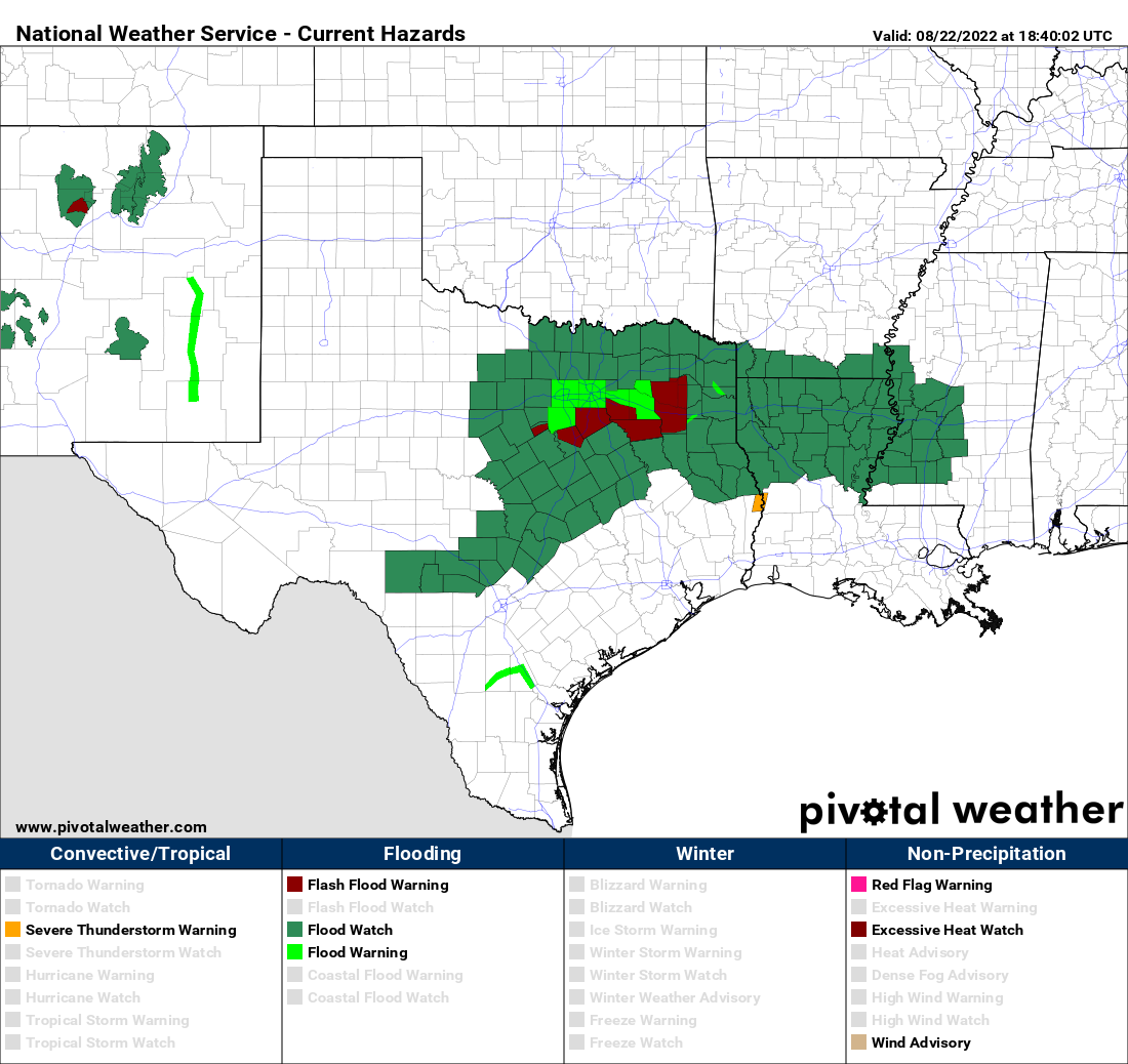
Look for flood watches and warnings to shift through the week as the rainfall threat shifts.
Tuesday and Wednesday’s risks
Both Tuesday and Wednesday will see rain drop closer to Houston. We aren’t expecting the level of tremendous rain rates and flooding as seen in Dallas, but we’ll want to watch things closely over the next few days, as model precision in handling rain rates through these types of events is rather poor. As of now, the primary risk of flooding rains will extend from just northeast of San Antonio across northern parts of Houston into Louisiana tomorrow.
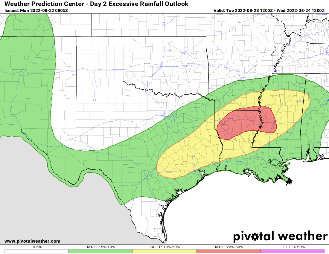
Then on Wednesday we’ll deal with residual rain chances in Houston and most flooding risks in Louisiana.
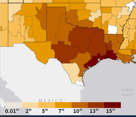
Will this end the drought?
Yes and no. Drought is complicated. The amount of rainfall needed to officially end the drought in Texas is 10 to 15 inches over a wide swath of the state. Other than the Dallas area, we aren’t seeing those kinds of totals over a wide enough area.
Drought is a little more complex than just needing a certain amount of rain, however. There are longer-term droughts, like the one Texas is in, which impacts agriculture, deep soil moisture, water supply, etc. Then there is short-term drought, which we also have had this summer. That leads to all of the above but also things like wildfire risk. This rain will absolutely help, if not end the short-term drought in much of eastern Texas. It will help the long-term drought as well, but we will need more rain in the coming weeks in order for that to be effective. I spoke a bit about this on Texas Standard this morning.
Why is this so bad so fast?
There’s a saying that droughts end in floods for a reason. Texas is a state of extremes, becoming further exacerbated in a warming climate. In this case, a persistent weather pattern that plagued us with drought and heat all summer finally flipped, simultaneous to a bunch of added moisture from the Southwest monsoon (which itself may have been energized somewhat by the old tropical disturbance that flooded parts of South Texas over a week ago), as well as added moisture from this weekend’s PTC 4 that went into Mexico. All of this hit a sagging cold front, and someone will get slammed in that instance.
In a timely turn of events, new research has come out showing how dry soil can exacerbate flooding issues with heavy rain. You can read about that here.
The bottom line: Texas has a history of droughts ending with floods. That’s sort of what’s happening here. While this may not necessarily be the “end” of drought for all of Texas, it will be for some of the state. Please use caution and stay aware of rain risks over the next few days as it all moves through.
What is the weather looking like for the upcoming labor day weekend? Does it look like the wet weather pattern will continue? Trying to plan ahead. Thanks!
I would anticipate a wetter and cooler than normal pattern to continue, but I am skeptical it would be a washout right now. So plan normal for now!
interesting book:
https://www.tamupress.com/book/9781585445905/flash-floods-in-texas/
I strongly second this recommendation. This book is on my shelf and makes for an interesting reference.
Matt may I suggest a “bookshelf” link on the homepage? ( George Bomar’s Texas Weather got me interested in the topic some years ago.) Or a list of web links to useful weather sites.
This is exactly the update I was looking for. Many thanks!
Why does it look like a heavy rain is coming straight towards Conroe and then disappears and reforms just south of conroe?
R we in some sort of weather erasing dome?
The funny thing is that if the rain is helped by moisture from the strong southwest monsoon, then because the monsoon was increased by the persistent high over Texas, that high’s effects are now helping to flood the same areas that it was keeping dry.
The rain setup over Dallas earlier today gave me flashbacks to the Tax Day and Memorial Day floods. Slow-moving front in just the wrong place, and plenty of moisture to work with. I hope we don’t see that kind of setup again around Houston (or anyplace else, for that matter) over the next few days.
How will the Houston area be impacted, if at all, when all of the rain currently falling on DFW drains toward the gulf?
I would expect the Trinity River to be most impacted by this. It’s possible the Brazos and San Jacinto Rivers also see rises, but I would anticipate minimal flooding issues for now. Thankfully the starting point on the big rivers was fairly low.
This seems sort of like the mid 1950s all over again.
I will never forget it being so dry that you could literally walk across White Rock lake in Dallas.
After enduring multiple years (1953-1956) of drought, it finally started raining.
And I remember Austin being badly flooded in 1957. After that, the drought was broken.
Anyone who has lived long enough (I have been here almost 72 years) in Texas kiows:
“If the floods don’t get you, then the drought will”
That is awesome to know that you were here during that time. I was born decades later but I’ve been fascinated with that subject. From the research I’ve done the 7 year drought in Texas was at its peak on 1956. The pattern suddenly changed during the spring of 1957 which led to numerous heavy rain event’s that caused several rivers to flood way out of their banks across Texas. The Brazos and San Bernard river met in Brazoria county causing disastrous flooding. I’ve talked to people who lived here at the time. Harvey was eerily similar to this event.