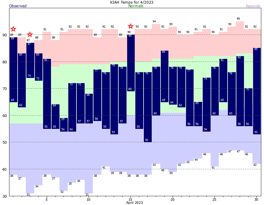
Good morning. Houston just experienced what was very likely its final truly spring-like weekend of the season, with temperatures bottoming out at 53 degrees on Sunday morning. We’re about five degrees warmer this morning, and after a few more nights in the 60s, lows are headed to the 70s by Friday morning, and we probably will stay there for awhile.
In truth, it has been a splendid spring. We have seen mild weather since mid-February, and while March was a few degrees above normal, April was a few degrees below normal. The bottom line is that we’ve had about 75 days of mostly temperate days and mostly cool-ish nights. To top it off, April brought some widespread rains that provided our region with a nice foundation of moisture heading into the hotter time of year. After these April showers, only Brazoria County is experiencing slightly drought-like conditions.
Of course all good things must come to an end. We still can see decent cold fronts in May, but time is running out. And there is scant sign of the next front in the models through the middle of the month. While things can certainly change, it seems pretty clear that spring is ending, and pre-summer has begun. For the next four to five months we can expect predominantly humid conditions, with warm to hot days. Some of you live for this weather, to which I say bless your hearts.
Monday
Quiet weather will prevail for much of this week due to a pattern known as an “omega block,” in which the pressure pattern over the continental United States looks like the Greek letter omega (Ω). With this pattern high pressure persists over the central part of the country while the coastal regions are under the influence of low pressure. For Houston that will mean partly sunny to mostly sunny weather through Thursday with moderate temperatures.

Expect highs today to reach about 85 degrees with mostly sunny skies. Light winds will turn more southerly this afternoon. Lows tonight will drop into the mid-60s with partly cloudy skies. Rain chances are zero.
Tuesday and Wednesday
Expect a pair of partly sunny days with highs in the mid-80s. Lows will again be in the 60s. Winds will generally be light, out of the east and southeast. Humidity will be slowly rising, but not reaching oppressive levels. So these days should be fairly nice.
Thursday and Friday
A more pronounced onshore flow resumes by Thursday or so, and this will lead to more humid air. Highs may hold on in the mid-80s on Thursday, but by Friday we’ll see temperatures close to 90 degrees. Both days have a slight chance of seeing some light rain, along with partly to mostly cloudy skies.
Saturday and Sunday
The weekend looks warm, with highs of around 90 degrees, and partly to mostly cloudy skies. Lows by this point will only be dropping into the mid-70s—so almost summertime lows. Rain chances are sort of a question mark at this point. The air will be moistening, and we’re going to see a few disturbances pass overhead. But is it all going to come together and produce some rain? I’ll broad-bush some 30 percent chances for both days, and hope to get a more precise forecast for you in a day or two.
Next week
The pattern we see this weekend looks set to continue for most of next week. So lots of upper 80s and possibly lower 90s, to go along with warm-ish nights. As I said, welcome to pre-summer, Houston.


Yes, the Global Warming zealots have been quiet lately A beautiful spring indeed!.
You don’t seem to understand how climate change works.
kztoy, here’s a shiny toy – go play while the adults talk.
One month does not mean too much. You need to study years and decades, not a single month. Here’s a run down of monthly data starting in November:
Nov – 1.6 below average
Dec – 1.7 above average (even including the cold snap)
Jan – 4.1 above average
Feb – 2.8 above average
Mar – 3.4 above average
Apr – 1.9 below average
That is very true. Since 2015 most months have averaged above normal with a few sharply below average months here and there. But overall temperatures have been well above normal for years here in the Houston area. The last cooler than normal years we had where 2013 and 2014. I have hoped for another “coolish” year like that again but it seems like a pipe dream at this point.
How about closer to the Corpus Christi area?
We didn’t see much rain inside the loop for April. Hobby is now reporting 10.5 inches below normal for the year. That lines up with the very dry weather seen here at least. So we’re either going to catch up with some epic rain events or the new normal is a very dry place.
I think that the pattern will start to shift toward more wet rainy weather this fall and winter since they are predicted a pretty solid El Nino to develop this summer. We may end up with the exact opposite problem next year. However that is no guarantee because the weather is always going to weather. By that I mean stay unpredictable lol. Hopefully we don’t end up with another region wide flood where rivers are literally overflowing there banks like what happened in the Spring of 2016. And god please not another Harvey.
The past several weeks have saved me a great deal on utilities, with no heat and no AC. I ‘ve been able to wear spring jackets and sweaters in the evenings. Hopefully it will stay cool enough not to need AC for a little longer.
It was a wonderful Spring!
By “pre-summer” I assume you mean “summer”, and by “summer” I assume you mean “super summer” 🙂
6 months of swamp weather has started. Too miserable to step outside.