After this morning, Houston has two more somewhat cool nights—with lows in the 60s and not oppressively high dewpoints—before things begin to warm up toward the weekend. By Friday morning we’re going to see lows only in the 70s with more humidity and well, that’s a fairly typical pattern for summer-time weather. So let’s talk about summer, which typically lasts about five months in Houston.
By strict definition “meteorological” summer runs from June through August, and “solstice” summer runs from June 21 through September 22 this year. For me, Houston’s summer typically runs from about mid-May through mid-October. Here are the four phases:
- Early summer: When we first start to see 90-degree temperatures with some regularity, but some nights in the 60s are still possible, and there’s still the thinnest hope of a weak front
- Mid summer: When highs run from 90 to 95 degrees, and nights are sultry, but you know it could still get worse
- High summer: Somewhere between late July and early September there’s a period where temperatures reach the upper 90s to low 100s and you realize, “Ok, this really is the worst.”
- Late summer: This is the period in September and early October when days grow shorter and we usually see the first front or two of the season. But most of the time it’s still hot.
We’re going to reach early summer this weekend, when we probably will see a handful of 90-degree days.
Tuesday
Today will be the last of three days with temperatures in the low- to mid-80s. High pressure will help to maintain an easterly flow, so we’re going to see a mix of sunshine and clouds, with clouds likely becoming more predominant later this afternoon. Winds will be light, out of the east. Low temperatures tonight will drop into the mid-60s in Houston, with cooler conditions further inland.
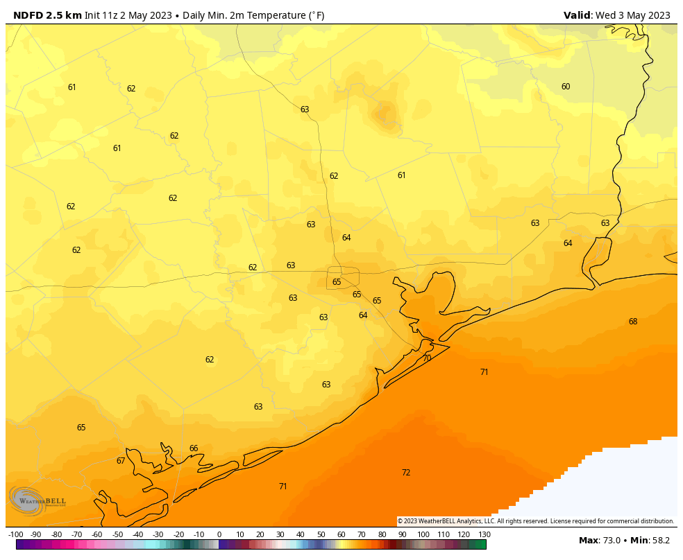
Wednesday
Temperatures on Wednesday will reach the mid-80s, and we’re going to see a fair bit of sunshine. For a few hours on Wednesday afternoon we should actually see dewpoints drop into the 50s, which is going to be our last smidgeon of dry air for awhile. So maybe step outside and enjoy that last bit of light humidity. Because you know what’s coming, right? Winds will be light, and overnight lows will again drop into the mid-60s.
Thursday
We’ll see one more day with temperatures in the mid-80s, but with more clouds than Wednesday. Winds will also be more pronounced out of the south, gusting to 20 mph or even a bit higher. This, my friends, is the full-on return of the onshore flow from the Gulf of Mexico. As a result, lows on Thursday night will only drop into the low 70s. There is a slight chance of light showers on Thursday night.
Friday
Despite mostly cloudy skies, we’re going to see warm and humid weather on Friday, with highs near 90 degrees. Rain chances are about 20 percent.
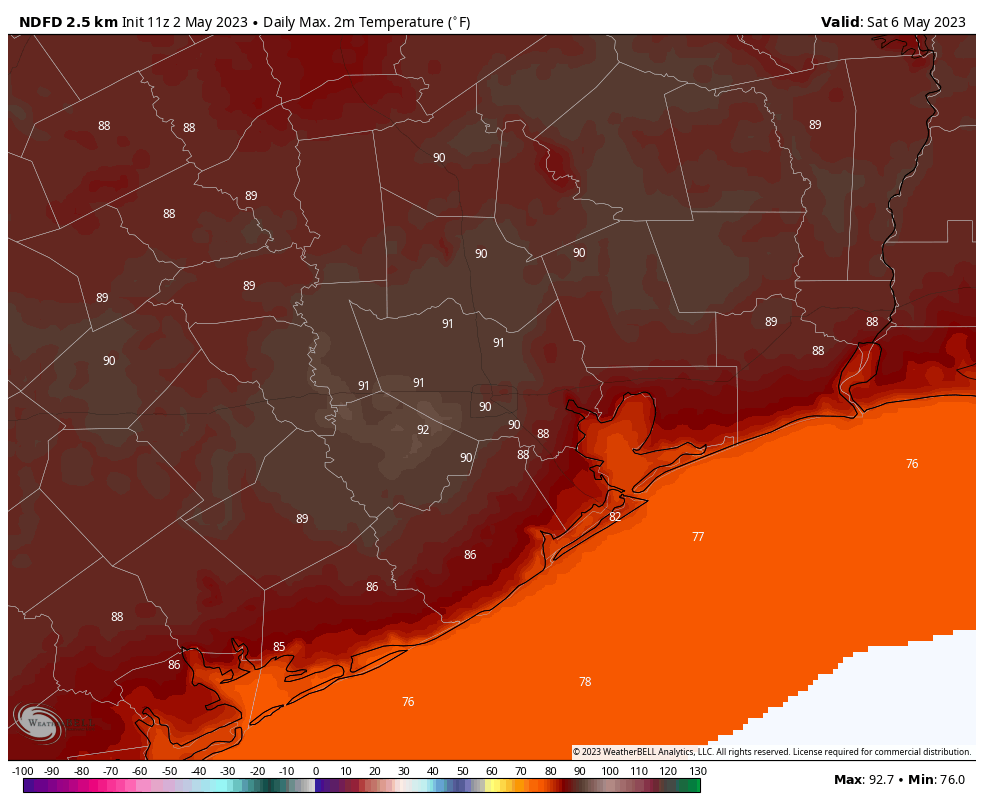
Saturday and Sunday
Expect more of the same this weekend, with partly to mostly cloudy skies and high temperatures of around 90 degrees. Given the moisture and a bit of instability to work with, we could see some scattered showers or possibly even a thunderstorm each day. But overall chances are probably only on the order of 20 percent. If you have plans, we’ll try to refine this forecast in the days ahead.
Next week
Temperatures back off a bit next week, maybe. Rain chances perhaps will go up. I’d ballpark chances at 20 to 40 percent each day, but my overall confidence is low. The humidity looks to stick around. The models are hinting at a chance for a weak front in 10 to 14 days, but that is far enough in the future that I’d probably not even be writing that in pencil yet. Settle in, y’all. Summer is at the gates.


Mid-summer: … “you know it could be worse”
High summer: Worse.
Love all phases of summer. Bring it on (except for hurricanes).
😭😭😭
I don’t even care about the heat. It’s the humidity that makes you feel like you need scuba gear to take a walk to the mailbox. When I had my last cup of coffee with the back door open to morning temps in the upper 50s until next winter, I cried.
Hot and Humid is fine. Drought is the bane. Counting last year and up to now we are 20+ inches below normal. Afternoon thunderstorms provide a lot of relief. I’m curious if people think it’s dry or just about right.
Hot and humid is never fine. Only alligators think this is so.
😅. If you could float around in water all day you’d be pretty happy. Except when it’s cold out.
Up north, they divide up winter the way you divided up summer.
The best part of summer is none of it.
You could always move.
You could just chill out Matt
Matt and Blackhawks can both go chill up north. They got snow pretty recently.
I grew up in SLC, UT. But I have lived down here for 23 of the past 26+ years (came here for work, not because I wanted to). All of the snow that fell in the mountains just east of SLC is now rapidly melting. And all seven of the “creeks” that drain out of the canyons on the east side of the Salt Lake Valley are all at flood stage and above, flooding houses and businesses. And all of the rivers that drain into the Great Salt Lake are also flooding.
Although I hate the heat and humidity here, I do not miss shoveling snow, or worrying about the excess snow collapsing the roof of my home. Everywhere has its plusses and drawbacks….
Just have to worry about the hurricanes that occasionally hit here unfortunately.
That is true. What I hate worse though are the deluges that we seem to get where an inch to 2″ seems to fall in like 15 minutes. I am getting real sick of that. At least my lot drains well.
Just got my AC serviced, Come on Summer I am ready for you!
When it the good time to remodel my siding ?please advise tks