Several posts in our Weather Why series deal with hurricanes. In the past, we have discussed what affects a hurricane’s path, as well as why winds are strongest on the right side of a hurricane. As the peak of the Atlantic hurricane season draws near, we wanted to focus on the part of a hurricane that impacts people along the cost the most—storm surge.
While many people are concerned with rain, wind, and tornado risks when discussing the impact of hurricanes, the storm surge is by far the most dangerous factor. A 2014 study by the National Hurricane Center showed that 49 percent of all deaths attributable to a hurricane or tropical storm come from storm surges (by comparison, hurricane-spawned tornadoes only account for 3 percent of tropical storm and hurricane deaths). So what causes the storm surge? And when a tropical system makes landfall, what can you do to avoid it?
Storm Surge
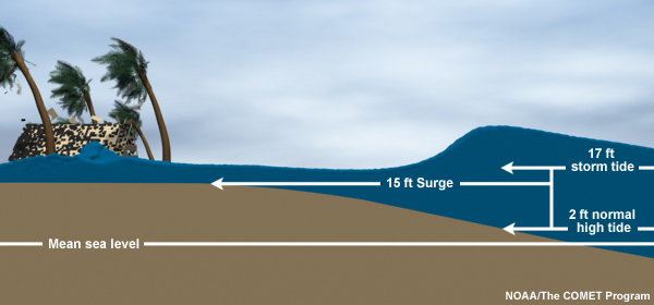
A storm surge is a steady rise in water, above mean sea level, due to the presence of a storm. It is not, as often described, a ‘wall’ of water, a la Hollywood disaster movies. Approximately 95 percent of the rise is due to winds from the storm pushing water toward the shore, while the remaining 5 percent results from a small rise due to the lower atmospheric pressure around a tropical system. If a hurricane creates a 15 foot high storm surge that occurs in conjunction with a natural, 2 foot high tide, this would create a 17 foot storm tide. Depending on if the tide is high or low during a hurricane’s landfall, a storm’s impact can be significantly enhanced—or, mitigated.
Several factors go into predicting a storm surge. Strength of wind is obviously important, but other variables must be considered, including the width and slope of the continental shelf, storm speed and size, storm angle of landfall relative to the shoreline, and the shape of the shoreline. Just because a hurricane is a Category 4 on the Saffir-Simpson scale, that doesn’t mean the storm surge would be stronger than, say, a Category 1 hurricane. For example, Hurricane Ike (a Cat. 2) produced a 15-20 foot surge, while Hurricane Charlie (a Cat. 4) hit the gulf coast of Florida in 2004 and only produced a 6 foot surge.

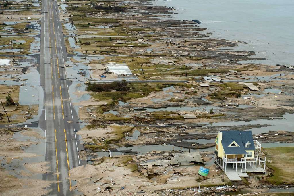
Storm surge has a tremendous impact on the coastline when a tropical system makes landfall. While land erodes from beneath, strong, tall waves of water damage or destroy the structure itself. This animation created by the National Weather Service shows how the water impacts the shoreline. You’ve seen photos from Hurricane Ike before, especially like the one below, but they serve to show the true impact of storm surge, especially on the Texas coastline.

How do you avoid a storm surge?
The most foolproof way of avoiding a storm surge is, obviously, to go where the storm surge isn’t. When the National Weather Service issues mandatory evacuations, especially along the coast, it means that area is susceptible to the storm surge. And though you may have a ‘stormproof’ house on stilts, as you can see from the photo above–that’s not a guarantee of anything! It’s always a good rule to evacuate sooner, rather than later. A storm surge can approach well ahead of the tropical system itself, and potentially cut off evacuation routes. So plan ahead of time, and listen to officials!
If you’re interested in viewing the potential storm surge in our region, the National Hurricane Center has this handy map, which shows modeled storm surge levels based on hurricane category. Just keep in mind that this is not a real-time product, and different storms will have vastly different effects.


Good read, good illustrations. Thanks!