The radar is mostly quiet this morning across the region, but that will soon change with the onset of showers and thunderstorms later today. From there on we will enter a very wet, and somewhat unpredictable period, during which rainfall should peak from Thursday evening through Saturday. Below, we do our best to assess this mess, and use our new flood scale for the first time.
Tuesday
Generally, we expect rain showers and thunderstorms to develop south and west of Houston this morning, and then migrate north of I-10 later today. But admittedly, that is just a guess. The high-resolution models we use to predict the development of these small-scale storm systems have been failing us of late, so we don’t have great confidence in these storms. Accumulations of 0.5 to 1.5 inches are possible for some areas today, while parts of the region are likely to see no rainfall at all. Highs will only reach about 80 degrees. Lighter rain will be possible Tuesday night, but most of the region should see a break.
Wednesday
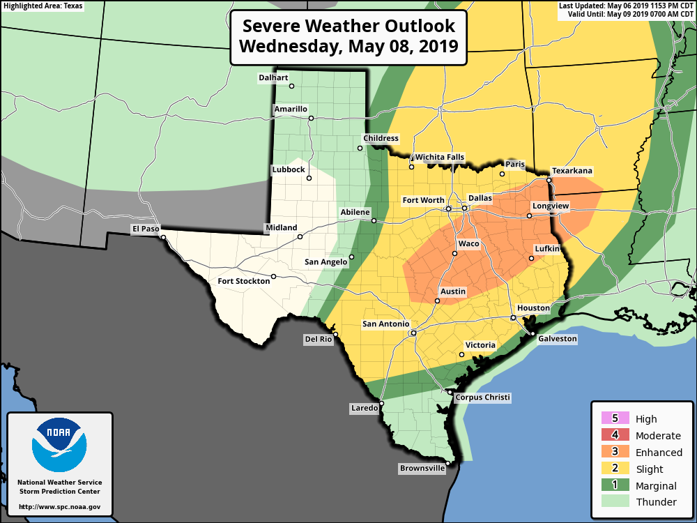
The weather story for Wednesday will be the propagation of an upper-level system across northern Texas, which will drive the potential for severe weather over parts of Texas, including Austin, and East Texas (see map above). It remains to be seen how close these storms come to the Houston metro area, but Waller, Walker, and Montgomery counties could well see damaging winds and hail in addition to 1 to 2 inches of rainfall. Southern parts of the Houston region may not see too much rain Wednesday.

Thursday, Friday, and Saturday
Here’s the part of the forecast where we run into real uncertainty, and our biggest concerns. The front moving across Texas on Tuesday and Wednesday will likely stall somewhere over the greater Houston region at the end of this week, and wobble around. It is not possible to predict where this will occur—Interstate 10? the coast?—but the bottom line is that this surface front combined with favorable upper-level dynamics to produce widespread, heavy rainfall for much of the region. Because we’re uncertain where the boundary stalls, it’s not really possible to say where the heaviest rainfall will come at this time.
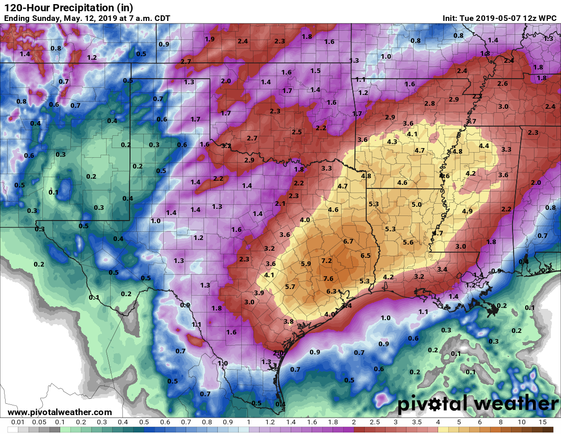
Generally, I’d expect most parts of Houston to get 2 to 6 inches of rain from now through Sunday morning—which should be totally manageable. However, some parts of the region will probably get 10 or more inches. This bullseye could happen almost anywhere near Houston—in Liberty County, downtown Houston, Fort Bend County, or somewhere else. Because of this bullseye potential; accumulating rain totals over a five-day period; and the likelihood of river flooding, especially along the Trinity or Brazos rivers; we’re rating the potential impacts for this weekend as a Stage Two flood on the Space City Weather Flood Scale, which ranks flood events from 1 (street flooding) to 5 (Harvey).

Sunday and beyond
It appears as though the wobbling front will finally move off later on Saturday or Sunday morning, which could lead to some clearing skies and nicer weather for the second half of the weekend. Perhaps Sunday will live up to its name—or perhaps clouds won’t move off until the evening.
There is some question about conditions next week, and the European model keeps us fairly dry, but the GFS returns the potential for heavy rainfall as early as Tuesday. At this point I’d lean toward the drier European model.
Have a graduation party Friday evening in El Lago—will people be able to make it across town to come? Also family flying into Hobby on Thursday afternoon for the graduation—they don’t like to fly and are concerned about the storms. Will there be problems Thursday afternoon?
Without knowing where the front stalls it is going to be hard to pinpoint such exacting situations. I would keep an eye here for further updates as things develop.
Amen, Ben. This is a weather FORECAST not a foretelling of a future certainty.
Thanks for trolling your fellow Houstonian, Blackhawks fan.
Thank you for the well thought out and informative update. We flooded during Harvey and I am one of those people whose anxiety hits the roof every time there’s a threat of flooding. Thank you for the scale. It’s very useful. May I suggest doing a post-event scale as well that can provide reference and further understanding?
Do I understand correctly that the flood scale will be applied to the Houston region, as a whole, or will there be some attempt to vary the rating for particular subregions? Thanks, I think it’s a great idea to implement.
Is there any way to add an overlay to the map showing the Brazos River? I’d like to see the rain projections in the Brazos River watershed. The levels are already high and I wonder how the system coming in will effect the levels over the next week.
I’m a new subscriber & am finding your weather forecasting to be so much better than I can find anywhere else. Refreshing.
Thanks for finding us, Gayle!
Thanks Eric and Matt for the great updates.
You guys are awesome. Thanks for this important public service!
With a changing climate and ever expanding cityscape, we will need you more than ever in the future.
Thank you!
What about College Station? A&M graduations to go to on Thursday and Friday.
Neither day looks good for any sort of outdoor activities.
I believe this will be appropriate considering the level of quality and honesty in your continued weather reporting.
A fiesta will most certainly ensue once you click this link!
Thank you for the forecast. This may be a silly question but how often to the forecast models update?
Depends on the model. Globals update every 6- to 12-hours. A lot of the regional models update every 6 hours. Some of the very high resolution models such as the HRRR update every hour.
Wow that is a lot of updating. Will you send out additional forecasts (more than 1 a day) if changes occur?
I’ve got to say, I love the new ranking system. Thanks for all of the effort and thought you guys sink into this stuff, it’s a HUGE help to get the background information! My personal interpretation of how to react:
Stage 1: Slow down and pay attention. Heavy rains are coming, traffic will be BAD, and a few local spots will have water in the streets but this is more of a “slowly draining” than a “water rising” situation. Pay Attention but go about a mostly normal day. Don’t forget to pay attention and slow down.
Stage 2: Extra heavy rains are coming, localized streets will see large impacts (possibly be closed) – we just don’t know where. Pay attention. Don’t be dumb and don’t drive through water. Plan to be caught in an extra heavy rain situation (because you may if you’re in the wrong spot at the wrong time – all up to chance) but don’t worry about your house.
Stage 3: If you have flooded on multiple occasions (like the home I grew up in) – take precautions because you may flood now. Everyone else – avoid those spots and limit your “out and about” time to tasks that are absolutely necessary. Otherwise, stay home and watch the rain.
Stage 4: Stay home and pay close attention to weather reports for your local spot. React accordingly. Don’t evacuate the city but be prepared to take care of your family and your stuff just in case.
Stage 5: We all remember Harvey or we wouldn’t be on this site…
The cooler temps and lack of sun will be welcome at work. The A/C in our building is out for the third time in two weeks.
Such a meaningless comment. No one cares about your AC. Move along
Dang.
You mad bro? Show some sympathy. Houston wouldn’t be the city it is today without A/C.
Thank you! I guess I’m not the only one tired of his complaints! Don’t worry about flooding, folks, blackhawks fan is going to be spared from the heat!
Well, this could make the drive downtown for Comicpalooza all sorts of entertaining this year. Here’s hoping that the street impacts are minimized. Thanks, as always, Eric.
I should ask, do you guys have any plans on moving into app-space going forward? I had to retire WeatherUnderground after years of use this past week when it failed to notice that we had tornado warnings. . . .
We’re looking into an app, but it would require a large commitment of time and resources.
Really appreciate the Stages, but extremely confused. Stage 2 is equated to May 2016, which was far worse than April 2016, which is Stage 4. Both caused flooding in my home (1.5 ft in April & 5 ft in May), but May 2015, at Stage 3 did not. Worse yet, the 2016 floods were both worse than the two hurricanes listed (other than Harvey which was 13ft). And those are Stage 4/5.
I get that Stage 2 is not at those extremes, but I have no way of fully understanding the Stages when the reference points are opposite of what I would expect.
Any guidance and clarity is appreciated.
You are taking it far too personal. I’m not trying to offend, but the scale is about more of an overall impact on the area. Weather is uncertain and difficult to predict, so you have to be able to step back and look at it in bigger chunks. Your mileage may personally vary as far as the impacts and previous dates listed goes, but Eric and Matt are trying to take a step back and give us the whole picture. If you know that your street has had issues in the past on lesser events, educate yourself as to the parameters that caused those previous events and make adjustments to the forecast and outlines like this for your own interpretation of how a weather system could potentially impact you.
Weather is weird. One person can go completely unaffected while another just a few blocks away can lose everything. Weather forecasts are NEVER about your home, your street, your minute by minute calendar. My advice is for all of those concerned about “okay but how is this going to affect ME” is to take a step back and educate yourself, even if its just a little bit, on how difficult of a job meteorologist have and just how many factors go into putting together a forecast. You’ll learn to appreciate the info that people like Eric and Matt put out there for the masses for free a whole lot more and be better able to understand what it could mean for you.
I do appreciate what they do, which is why I want badly to use the new tool. I don’t see how I am taking anything personally. This is about understanding the reference points in order to make an informed decision about any potential actions to take.
Not only have I educated myself by attending seminars and having one on one conversations with other meteorologists, but I have analyzed 25 years worth of rain and river history to better gauge the impact of any given event.
I am now attempting to correlate that data to match up with the Flood Stage tool (and I would guess, much as they did). My guess is that their data points are from different locations than mine, but without knowing those data points, I can’t make adjustments.
Thank you for the updates on this! A question: how “patchy” do you think this weather will be when it comes to flight cancellations–i.e. is this the sort of thing where flights might mainly just be delayed (waiting for patches of weather to pass over / less flights being able to get in/out) or full on blanket cancellations?
I need to make it to another state for work by Friday AM, so I’ve booked a Thursday AM flight out (e.g. so it’s OK if it gets crazy delayed or cancelled / rebooked for Friday AM). I’m trying to figure out if I should rebook for Wednesday or if the weather on Thursday will be “workable” at some point for making it out.
Thanks!
THank you a million times over for reasonable and honest forecasts that we can all understand. One question: since we are a bit behind on rainfall and the grounds can absorb a bit more due to that, do you think vulnerable neighborhoods will still flood? I live in Meyerland where we are all nervous. Thanks a bunch
Looks like I’d better clear out the storm drains in the back yard. And of course a trip to Spec’s…
Eric & Matt: Do you expect widespread rain in central Houston on Wednesday between 7 am and 10 am? May 8th is national Walk & Bike to School Day (http://www.walkbiketoschool.org/) and several school arrival events are scheduled. I’m wondering if we should wave people off (by email this evening), or if we will likely be fine/dry? Thanks in advance for your expert guidance! Robin
My guess is tomorrow morning is OK. But I don’t have super-high confidence in that.
Thanks, Eric!