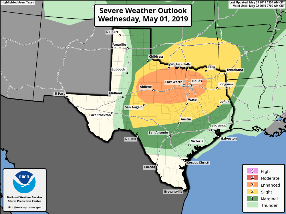
Good morning. Houston will remain in a muggy, partly cloudy, and somewhat rainy period through Saturday, but we have no major concerns. However, the same cannot be said today for northern Texas, particularly the I-20 corridor from Abilene through Dallas and Fort Worth. Severe storms could affect the Metroplex during the afternoon, and evening hours, with the distinct threat of large hail, heavy rainfall, and potentially tornadoes. Please take care if you’re traveling that way today or tonight.
Wednesday and Thursday
Back in Houston, conditions will be much more sedate. We’re going to continue under a pattern of a warmer southerly flow, with breezy winds from the Gulf bringing moisture into the area. Both Wednesday and Thursday should see some sunshine, which will allow highs to nudge up into the upper-80s for most areas, likely.
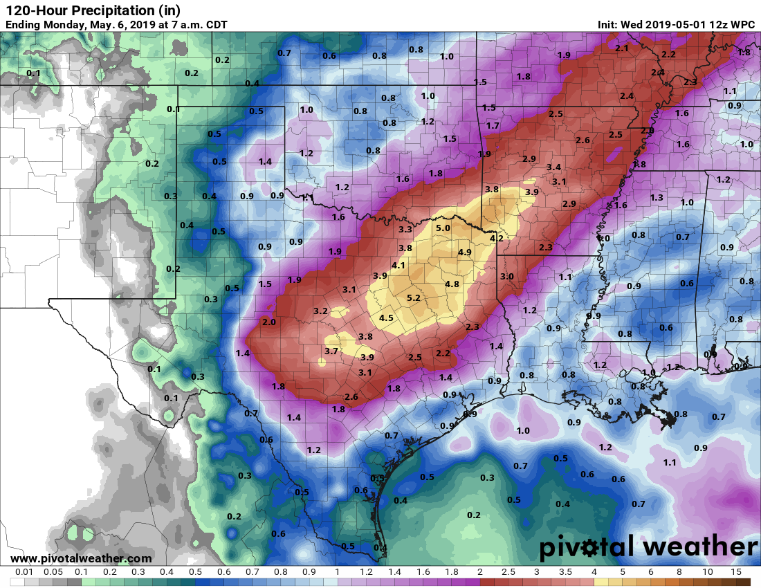
The bigger question is rainfall, and I think we’re going to see some light to moderate rain showers over the northern half of the area (think north of I-10), while southern areas remain pretty much dry. Overall inland parts of the region could see as much as one-half inch of rain through Thursday, but it should be nothing to write home about in terms of impacts. Nights will remain steamy, in the low 70s.

Friday and Saturday
Somewhat more dynamic weather may arrive by the end of the week as a weak front pushes down toward Houston. Most forecast models are converging on a scenario in which some sort of mass of showers pushes through the region from Friday afternoon through Saturday morning. While we cannot rule out heavy rainfall at this point—it is spring, after all, and moisture levels are high—right now most of the region probably will see 0.5 to 1.5 inch of rain from whatever’s coming, so beyond some intermittently strong thunderstorms it should not be too impactful. But we’ll keep an eye Friday evening’s commute, and the potential for any overnight storms.
Saturday afternoon will hopefully see some clearing skies, with a clear night on tap. The front won’t bring too much cooling, but we might see some moderately drier air and that would be nice.
Sunday
This continues to look like the prime pick for the weekend, with sunny skies and highs in the upper 80s inviting outdoor water activity.
Next week
This drier air won’t last too long, however, with the onshore flow (and associated moisture) likely returning by Monday, and bringing at least 20 to 30 percent rain chances back into the forecast along with it. Temperatures look to remain mostly in the 80s, with continued warm nights.
Our church has an outdoor event planned in Richmond tonight. Would you say we are good to go as far as no rain? I know only God controls the weather, and we are certainly asking Him for no rain. 🙂
Hi Dave. Can’t rule out some very light showers in Richmond this evening, but I’d bet against it.
Thanks for all you do. How does Galveston beach look Friday, Sat and Sunday? Same as Houston, a little better, or a little worse ? Thanks in advance!
Galveston will probably be a little bit better. The moisture looks like it mostly north of Houston and the onshore flow should mean any thermal uplift will be over the mainland instead of the island
thanks!
Heading north to chase tornadoes, wish me luck.
Username checks out.
Agreed!