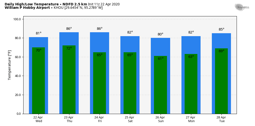
Houston will see the threat of severe weather this afternoon and early evening as a storm system moves through the region, ahead of a cool front. After this we expect several days of dry, sunny weather to dominate the region. It will be warm, but not too warm for late spring, with some reasonably cool nights this weekend.
Wednesday
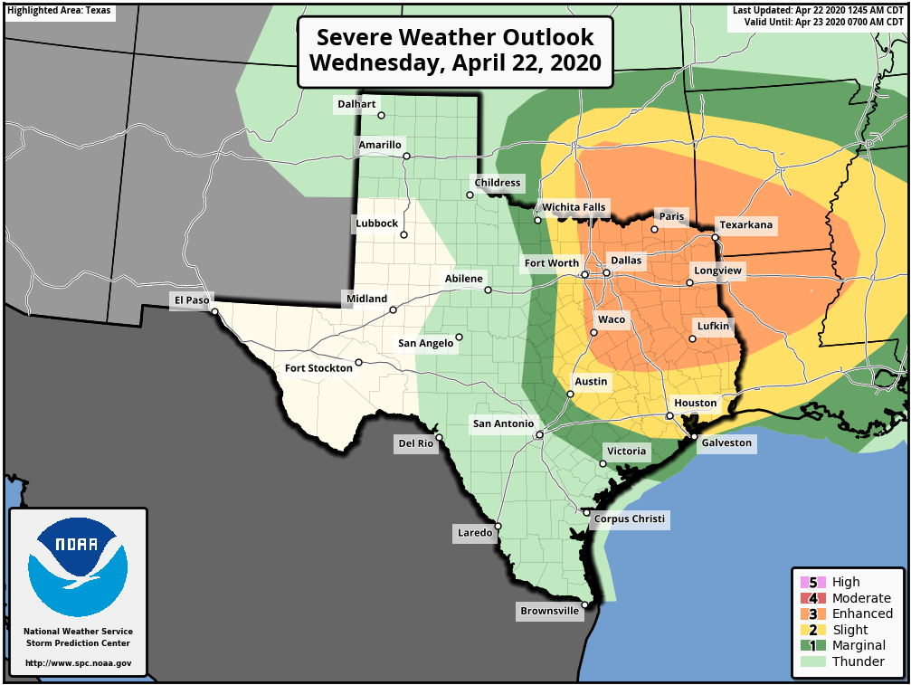
Temperatures this morning are in the mid-70s, with cloudy skies. Unlike Monday and Tuesday, however, we won’t experience much if any clearing skies later today. Instead, the region will see an increasing chance of storms. The bigger threat lies north of the metro area, over areas such as Lufkin and Waco, but almost the entire Houston region faces a “slight” chance of hail and damaging winds. The rain chances with this storm system are pretty meager for Houston, especially areas south of Interstate 10, as the capping inversion may prove unbreakable. That’s unfortunate, because there are a lot of dry areas such as Brazoria County that could use some precipitation and probably won’t get much, if any with this system.
Thursday
A secondary, thin and broken line of showers may pass through the area early Thursday before sunrise along with the cool front itself. In its wake, we should see clearing skies and highs in the mid-80s on Thursday. Lows will drop into the mid-60s.

Friday
As southerly winds return on Friday (some gusts above 20 mph will be possible), the Houston region will see a warmer day with rising humidity. Expect high temperatures in the upper 80s, and some areas may briefly hit 90 degrees. Sunshine will predominate, with clear skies over night.
Saturday and Sunday
We would be in for a real cooker of a weekend if not for a second front pushing into the region on Friday night or early Saturday morning. Without much moisture to work with, we don’t expect much in the way of rainfall, but it should bring a pair of drier, sunny days for the weekend. Look for highs in the low 80s, and overnight temperatures in the low 60s for most of the metro area—warmer along the coast, and cooler inland.
Next week
After the weekend, we anticipate a warming trend for next week. The most likely outcome is hot and mostly sunny weather, with temperatures in the upper 80s to 90 degrees. The models are mixed as to whether an atmospheric disturbance will bring another shot of rain into the weekend around the middle of next week, so we’ll set aside those tea leaves to be read for another day.
It is brutal down here in Brazoria County.
yea it is. All the rain seems to break up right when it gets to us. Hard to get the pastures to grow for the cows without rain. Eric, see if you can talk to mother nature and tell her to send rain our way please.
Please explain capping inversions and how they control storm potential. Thanks.
warm surface air tends to rise. As it rises, it cools, but remains warmer than the pre-existing air at that higher level, so it keeps rising through the vertical air environment as long as it remains warmer than the air around it. If it can maintain that difference high enough, eventually it reaches dewpoint and condenses moisture into clouds, rain, storms, etc. A cap is a layer of warmer air above the surface air mass. As the surface air hits this layer, it’s rather suddenly no longer warmer than the surrounding air, so instead of rising, it starts sinks and stabilizes.
Why do we get such “caps”? Our geography. Desert mountain regions to our west and southwest generate plenty of hot and dry air that can slide across the top of our cooler, gulf moderated and moist air. Sometimes it’s weak or thin enough for the surface instability to punch it’s own hole through. Most of the time it’s strong enough it requires another forcing mechanism, like a front, dryline, outflow from other storms, etc
Thanks for the excellent explanation!!
Yes, capping explanation again please! And we certainly must have one over Sugar Land, as like Saturday, storm lines literally separated as they went above & below us
To build on the previous two comments, why specifically has Houston consistently been under the cap? Just luck? Or does it have something to do with our proximity to the coast?