Good afternoon. Overall, the forecast remains on track. Houston will experience scattered showers and a few thunderstorms this afternoon and early evening. The threat of severe weather will increase after sunset, and peak overnight, before storms clear the area on Tuesday morning. Let’s examine the dual threats tonight: Severe storms and flooding.
Severe storm potential
NOAA has updated its severe storm outlook for Monday and Monday night, and upgraded some parts of our region to a “moderate” chance of severe storms. This is the second highest level of threat, and is indicative of the potential for supercell thunderstorms. Such storms can produce large hail, strong wind gusts, and tornadoes. The area with the most favorable conditions for these storms later today and tonight is northwest of Houston, and includes Austin and College Station. Most of Houston faces a lesser albeit still notable threat tonight, while the coast is at less of a risk.
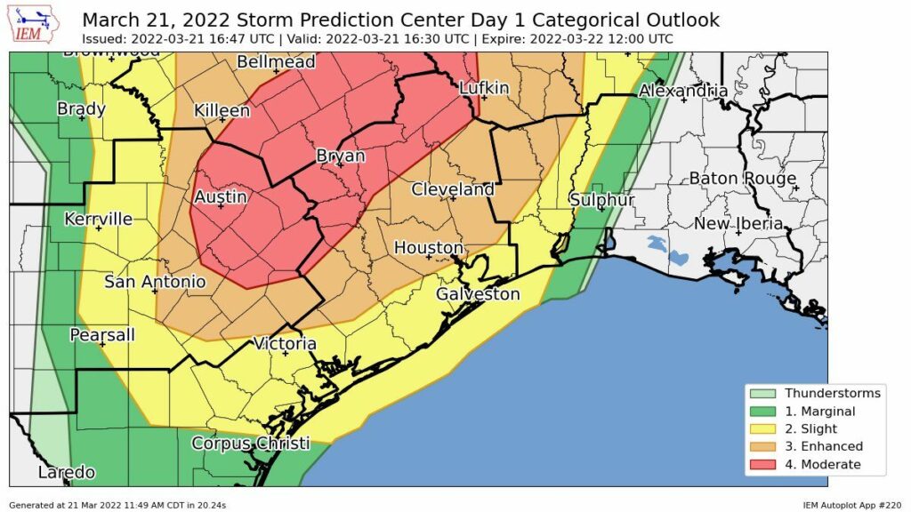
The bottom line is that strong and severe storms are possible tonight in the Houston metro area, particularly after 8 pm and continuing for about a 12-hour period. Not everyone will see severe weather, of course, and we cannot predict precisely where such storms will develop. So be weather aware, and take shelter in the event a tornado warning is issued.
Heavy rainfall potential
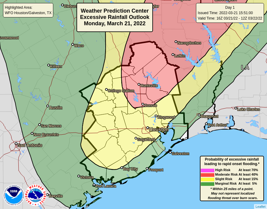
Later tonight the potential for heavier, training rainfall will also move into the picture. The problem is that as the cold front nears Houston early Tuesday it will start to slow down. This may cause storms to slow, and thus produce greater accumulations over certain areas. We’re still looking at 1 to 4 inches for most of the area, but bullseyes of 6 inches or more are possible for some locations, especially away from the coast. For this reason we’ve issued a Stage 1 Flood Alert for the metro are north of Interstate 10. Street flooding is possible in these locations.
The good news is that this mess will clear out pretty quickly on Tuesday morning, taking its rainfall off to our east. But it could make for a stormy night, and potentially a messy commute to work on Tuesday morning before that happens.
Matt will have an update for you later this evening.
Thanks Eric for the update, will keep my eyes peeled for the next one. Thank you for all you do!
Thx for the updates I look forward to seeing them for a more Accurate weather forecast!!
I always check your forecasts. I’m in Clear Lake and it’s nice to see coastal specifics! I’m a storm watcher. Thanks!
Thank you, it is so good to have a local out-look.
Keep up the good work, we are depending on you.
Check your messages EVERY day.
Taylor Roz
Can y’all implement an automatic “boot” for any tiresome Katy evacuation comments? Those ceased to be amusing about 2018 or thereabouts
Thanks for keeping us informed hype-free 🙂
I am up in Burleson. It is downright SCARY up here. Not liking this at all.
I live in Katy. Should I evacuate? 😉
Thank you for all you guys do.