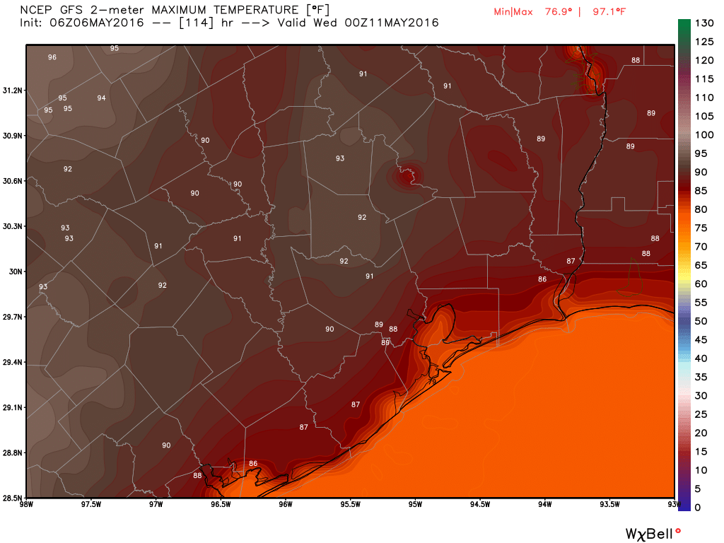
It’s another beautiful morning across the Houston area, with lows in the upper 50s across the northern half of the city, and the low 60s closer to the coast. But these temperate spring days won’t last as summer looms.
TODAY
Lots of sunshine with highs in the low 80s. By late tonight we will probably see winds begin to swing back around, and come out of the Gulf of Mexico, heralding the eventual return of moisture.
SATURDAY
A little bit warmer to start the day thatn Friday, in the low- to mid-60s across the city. But still nice, with mostly sunny skies and highs in the low 80s. A few clouds are possible.
SUNDAY
That southerly breeze continues to pick up, with gusts to about 20 mph. Under partly sunny skies we’ll see temperatures in the low 80s. Some slight rain chances, but I’d bet against it for almost everyone.
MONDAY
Breezy again, with better rain chances. The capping inversion will be weaker to the north of Houston, so I expect the best chances there. We may see a few tenths of an inch in the city itself, if that much. Again, most areas may not see much, if any rain.

TUESDAY through THURSDAY
Well, it will feel almost summer like. Houston will see partly sunny days, with highs in the upper 80s to perhaps 90 degrees, and a slight chance of some afternoon showers. Come to think of it, that is pretty much summer. So enjoy the next couple of days.
Yesterday got pretty darned warm!! Driving home in the convertible, the temp was 89 at one point!! After 90, the top goes back up and doesn’t come back down until October… *sigh*….
Eric, you said:
“Breezy again, with better rain chances. The capping inversion will be weaker to the north of Houston, so I expect the best chances there. We may see a few tenths of an inch in the city itself, if that much. Again, most areas may not see much, if any rain.”
I take it the models are STILL in agreement that the best chances for thunderstorms (heavy, or worse) are north of Houston? (Note I said STILL).
This what you’re talking about, Mr. Berger?
.PREV DISCUSSION… /ISSUED 329 PM CDT FRI MAY 6 2016/
DISCUSSION…
ONSHORE WINDS HAVE RETURNED AS SFC HIGH PRESSURE MOVES EAST OF THE
REGION. OTHER THAN SOME CIRRUS SKIRTING THE AREA…NOT EXPECTING
MUCH IN THE WAY OF CLOUD COVER TONIGHT. THE NAM AND SREF ENSEMBLE
GUIDANCE SUGGESTS SOME PATCHY FOG EARLY SATURDAY OVER THE W/SW
ZONES BUT NOT SURE LOW LEVEL MSTR WILL BE SUFFICIENT. CIRRUS
SHOULD BECOME A BIT MORE PREVALENT ON SATURDAY AND HAVE TRENDED
SKY GRIDS TO REFLECT PARTLY CLOUDY SKIES. THE GRADIENT WILL BEGIN
TO TIGHTEN ON SATURDAY AND WIND SPEEDS SHOULD BEGIN TO INCREASE.
THE GRADIENT TIGHTENS FURTHER ON SUN/MON AND BREEZY CONDS
EXPECTED AREAWIDE BOTH DAYS. CLOUDS INCREASE ON SUNDAY AS LOW
LEVEL MSTR DEEPENS. FCST SOUNDINGS SHOW A BUILDING CAP AND VERY
DRY AIR AT 800 MB. CLOUD COVER SHOULD BE THICK ENOUGH TO KEEP MAX
TEMPS IN LOWER/MID 80S. TEMPS WARM A BIT ON MONDAY AND PW VALUES
ALSO MOVE UPWARD. PW VALUES EXPECTED TO RISE TO AROUND 1.60-1.70
INCHES. CAPPING WEAKENS OVER THE NORTH AND WEAKENS TO A LESSER
EXTENT FURTHER SOUTH WITH CAPE VALUES APPROACHING 2000 AND LI`S
BETWEEN -6 TO -8. A WEAK S/WV WILL CROSS THE CENTRAL PLAINS ON
MONDAY AND THE TROUGH AXIS AND SFC DRY LINE SHOULD HELP TO
INITIATE SHRA/TSRA MONDAY AFTN. ITS UNCLEAR HOW FAR SOUTH THE
CONVECTION WILL BUILD BUT HAVE TAPERED HIGHER POPS NORTH WITH
LOWER POPS SOUTH AND TOWARD THE COAST. THE INSTABILITY LOOKS
SUFFICIENT FOR A FEW STRONG/POSSIBLY SEVERE STORMS OVER THE NORTH
LATE MON AFTN/EVENING.
“HIGHER POPS NORTH means north of Houston, like you said, right?