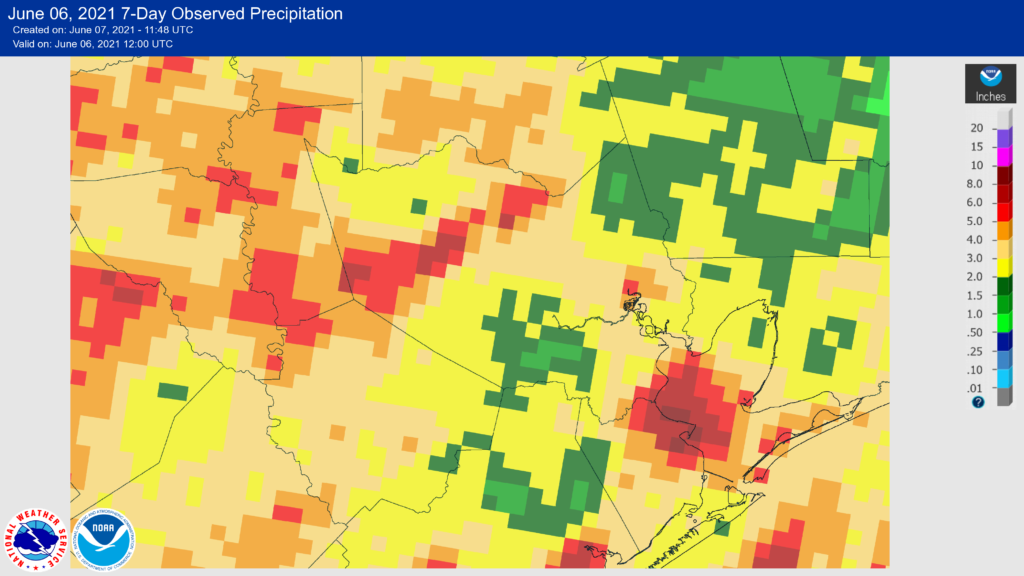
Good morning. The threat of widespread, heavy rainfall has ended, and Houston will now enter a much more summer-like pattern. Looking back at last week, the map below shows seven-day rainfall totals, which varied widely across the region. Much of the area saw between 3 and 10 inches of rain, which periodically led to street flooding under the stronger storms. This is more or less the definition of a Stage 1 flood event for us. We’re glad to move beyond it.

Monday
This morning has started out cloudy, but we should see more sunshine as the day goes on, and as a result high temperatures will likely reach about 90 degrees for much of the area. A few scattered, strong storms are possible mainly north of Interstate 10 later this morning and during the afternoon, but they should progress from west to east fairly quickly. Otherwise, it will be breezy, with winds out of the south at 10 to 15 mph, and gusting higher. Lows tonight will be sticky, in the upper 70s.
Tuesday and Wednesday
As high pressure builds this week, we’ll eventually reach a period of mostly sunny skies. However, by Tuesday and Wednesday the high won’t yet be fully established, so we’ll retain some slight rain chances—perhaps about 20 percent—each day. Otherwise we’ll see a mix of sunshine and clouds, along with highs of around 90 degrees.

Thursday and Friday
Right now I think both of these days will yield mostly sunny skies and warm summertime temperatures, with highs in the low 90s. Rain chances should be low to near-zero.
Saturday and Sunday
The weather for the coming weekend is a bit uncertain as a weak front will drift into Texas, and may make some progress toward our region. At this point I doubt it will have much effect on our temperatures, but it may allow for the development of scattered showers. At this point, I’d bet on hot and sunny this weekend, but I’m far from confident in that outlook. Stay tuned.
Tropics Outlook
The Atlantic hurricane season began a week ago, and we’re seeing some suggestions in the global models of potential activity in the Gulf of Mexico during the middle of next week. While this certainly seems possible, it is beyond the ability of any model to accurately depict what will happen that far out. My guess would be some sort of tropical depression may move into or form in the southern Gulf of Mexico, rather than anything significantly more organized.
However, it’s that time of year, and we’ll keep an eye on things for you because the Gulf is fairly warm already. In return, we ask that you not bite when someone on social media shares a single run, of a single model, depicting a hurricane in the Gulf ten or more days from now. That kind of information is just not credible and usually intended to stoke fear.
Sounds like I should probably fix my sprinkler system that broke in the freeze. Finally getting a hot, dry week.
Hey Guys,
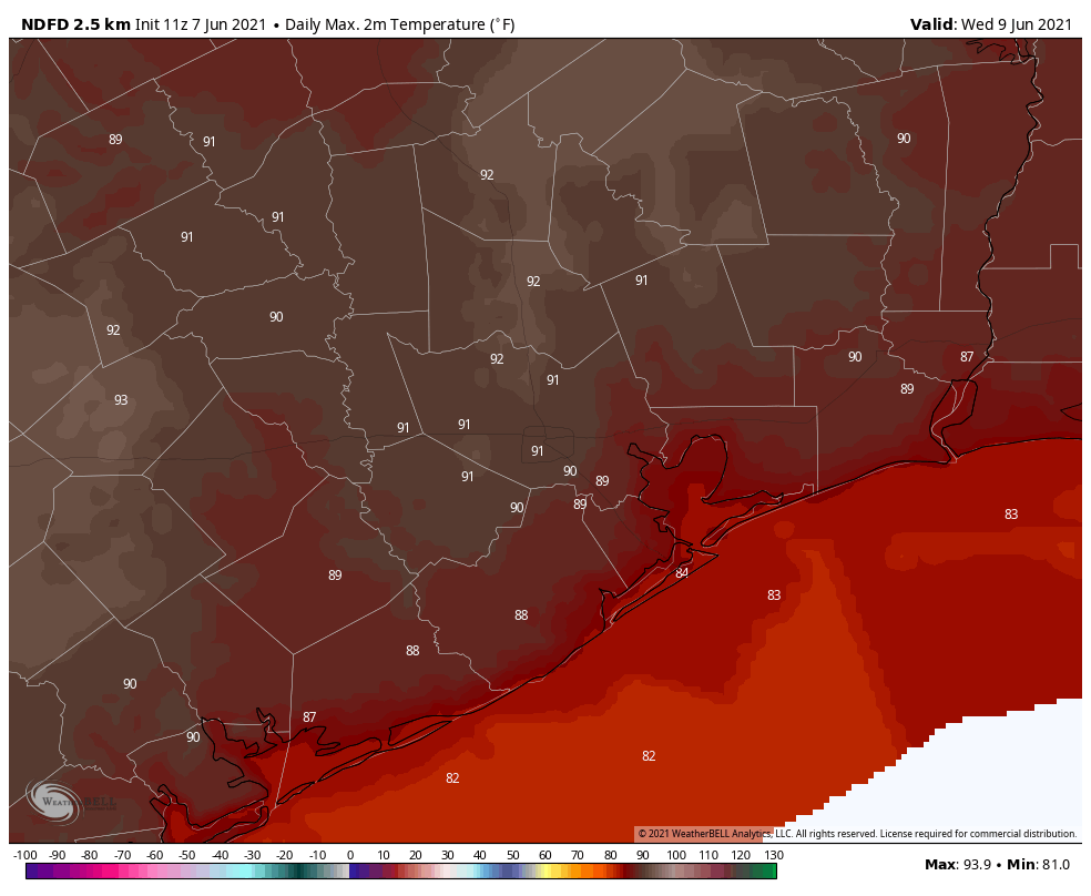
I’m a big fan and I’m sorry to be dumb, but you often show an uncoded and unscaled map of the region that is unintelligible to me, as you did today. The only place I can identify is Galveston. Are the other lines county lines, highways, rivers, zombie parade routes, or what? Somewhere apparently got a ton of rain but I don’t have the slightest idea where that is.
Coastlines are black, county lines are white, and the major highways are subdued.
That is on the temperature map. On the rainfall map, I think that there are just county lines and coastlines. Harris county is in the center.
I didn’t know either, so thanks for asking. 😉 And I wouldn’t be surprised to see Zombie parade routes around here 😀
i would also recommend clicking through on the source map photos, which usually takes you to the national NOAA sites or other sites where they cite their sources from. Clicking through to look at it full screen if you’re on a laptop or desktop instead of a phone can help with making more sense out of the maps. I, too, sometimes have trouble with them and have to look at them a while before the proverbial lightbulb goes on in my head. That is how I stumbled across clicking on it and it taking me to the source site such as NOAA for a larger image and map key.
It was starting to get a little brutal cutting the grass yesterday and the morning walk today. I guess the “S-word” is back and will be staying around another 5 months or so. Any word on when Canada is opening up to tourists???
“As we welcome back” 90-degree days”? Who is this “we” of which you speak?
Exactly what I was thinking. I’m perfectly fine with a little stage 1 alert for the rest of the summer if it keeps the 90s away
Addicks Reservoir Bear Creek Langham Creek water level is almost up to highway 6 now soooooo I’m cool with it not raining for a while so it can drain. Knew it was gonna fill up but when driving around Sunday did not expect it to be almost to road level. Whoa! That also would mean that George Bush Park is filled up too but I hadn’t gone to look at it yet. Which then will mean Buffalo Bayou will be high for a long while as those flood gates drain out. That Buffalo Bayou smell is going to get intense coming up soon!
I’m going to make my predictions for the weekend and following week based on the meteorological principle of Murphy’s Law. Since I’ve only got one weekend left to get my garden irrigation system installed, as I’ve been trying to do for the last two weeks, whatever rain is potential for next weekend will in fact happen.
And since I’m going on a road trip headed east on I-10 the following Friday, there will in fact be a hurricane in the Gulf as of the middle of next week.
I’m with Blackhawks Fan and note that it was pretty brutal this weekend being outside. I may be showing my age but I’m already over summer already.
With pandemic’s end, I’m giving heavy thought to bailing for a drier climate. I can put up with hot but “hot + humid + 6 months + floods + hurricanes” just may be too much.
I had my eye on colorado for a while, but as a small business owner, Texas has been good to me. Honestly not sure my business would have survived the pandemic in some of the other states.