Overall, the forecast remains pretty much the same. We’re watching for the possibility of storms on Friday night with the passage of a pretty robust cold front, and then looking for several days of really pleasant spring-time weather.
Thursday
The story for today will be winds. Onshore breezes will ramp up to 10 to 20 mph this afternoon, with higher gusts, in response to a large low pressure system in the Midwestern United States. Along with these winds, Houston should see a partly to mostly sunny day, with high temperatures around 80 degrees. A warm night, with lows only falling to around 70 degrees, will follow.
Friday through Saturday morning
Scattered showers, and a few thunderstorms, will be possible during the daytime on Friday as a cold front moves into Texas, but a capping inversion probably will keep most activity north of the Houston metro area. Most likely, we will have to wait until around sunset, or perhaps the overnight hours, for rain chances to really rise as the front moves through Houston.
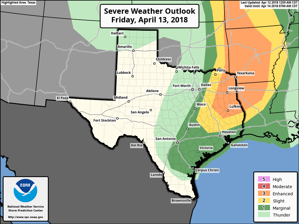
Forecast models indicate a relatively quickly moving line of storms is likely to form along the front, although it’s not clear how intense these storms will be as the slide down toward Houston and the coast. Most areas probably will see less than 1 inch of rain as the front rolls through, and if this line of storms is broken, parts of Houston may not see much rainfall at all. The front will push off the coast by around 7am on Saturday, ending the chances of any storms, although some light rain may linger for a few hours.

Saturday afternoon
The rest of Saturday will see clearing skies, and brisk northerly winds blowing into the area. It may get fairly gusty, with highs only in the 60s. Overnight temperatures will be quite cold for mid-April, with lows in the 30s possible north of the city. This, along with Sunday night, almost certainly will be the region’s coldest weather until October or November.
Sunday
The jewel of the weekend. After a cold start, look for mostly sunny skies on Sunday, with a high in the upper 60s to 70 degrees. Winds will have died down some, making this a perfect day for working outdoors or whatever you may have in mind. Expect another chilly night, with temperatures perhaps a degree or two warmer than Saturday night.
Next week
Most of next week looks quite nice, with highs generally warming to around 80 degrees after Monday, and overnight low temperatures in the 60s, and a fair amount of sunshine. At this point rain seems unlikely before the end of next week.
The “Next week” outlook is promising. Y’all can have the rest. Lol. Too windy and YES cold for this South Texan. Low of 60 high of 80 is pretty much perfect in my eyes. Cleaning my pool filter may have to wait until next weekend.
We have a fun run and community field day scheduled from 5-9 pm Fri in Pearland, nervous about weather. Thoughts?
Hmmm. I think there’s a decent chance you’ll skate by with no rain, or only intermittent, light showers. But we can’t rule out thunderstorms in that time frame.
***cautiously happy dance!!!!!***
Low 30s are cold for mid-December much less Mid-April. 🙂
It didn’t say low 30s. It said lows in the 30s are possible far north of the city, which could mean for example, 38.
How does it look in College Station for Friday late Friday afternoon’s outdoor senior ring presentations?
Not great, to be honest. I’d expect at least some scattered thunderstorms in the area.
They changed the ring day activities to indoors! Somewhere at Kyle Field.
Fabulous!!!!! Thank you.
I am planning a poolside crawfish boil on Saturday,in Conroe. But does not look like Saturday is turning out to be a swimming pool/crawfish boil kind a day. I don’t want to deal with cold or wind so would you suggest I reschedule seriously…. what would you do?
This is mainly about weather in the UK
but it could affect Houston too.
http://www.bbc.com/news/science-environment-43713719