As Eric has been alluding to all week, things have now changed, and they will continue to do so in a big way for not just Houston but all of Texas. Last evening’s rowdy (and in some cases damaging) storms were the first phase in what will be a much different weather pattern for the rest of the month. The Texas-wide drought is on notice for what should be significant relief.
Today
We’re starting the morning off with some noisy storms south of Houston. The storms are generally moving east, but the overall trend seems to be to build storms back to the north some. None are severe at this point, but there are some special marine warnings on the coast due to 35 to 45 mph wind gusts, or a bit stronger, as well as the potential for waterspouts.
As the day goes on, storms should continue expanding northward and inland. Locally heavy rain is again possible today. Thus far, rates are fairly manageable, but a few spots may need to be watched today for some street flooding. Most of Southeast Texas has been outlined in a marginal (Level 2/4) risk for flash flooding today. As a precaution, we are going to issue a Stage 1 Flood Alert, based on the SCW Flood Scale.

Street flooding is possible anywhere in the area today, but I would watch areas west of Houston that saw 2 to 3 inches of rain yesterday, as well as areas south of Houston, where the heaviest rain is right now. Yes, this is welcome rain to be sure, but some nuisance street flooding feels possible today, especially through early afternoon.
Storms should calm down by evening. Clouds and showers will keep temperatures down today. Highs should only be in the 80s, though if you see sunshine in your location, you could pop above 90, especially north and west of Houston.
Invest 99L & weekend
The weekend forecast will be hit and miss for most folks. At this point, I think both Saturday and Sunday carry a good chance of at least scattered showers or storms, near the coast in the morning, expanding inland during the afternoon. Locally heavy rain is possible, but widespread heavy rain seems unlikely this weekend. Both days should see some sunshine, which will allow us to punch back into the 90s in most spots, with morning lows in the 70s.
Regarding the tropics, the National Hurricane Center continues to highlight the potential for now-classified Invest 99L to become a tropical depression or storm over the next 24 hours before moving inland over Mexico on Saturday.
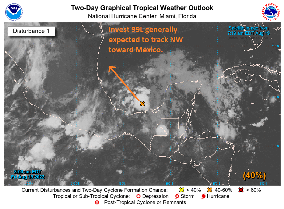
This should have no direct impact on our weather in the Houston area, but it’s possible that some heavier rains get close to South Texas later in the weekend or early next week.
Next week
I am not going to even try to pin down the specifics of any day next week. What we know is that there will be rain chances every day. Some of the rain could be heavy. Parts of the state are going to see a lot of rain (see below), probably to the north or northwest of the Houston area. Daytime highs will flirt with 90 every day, but days that see more widespread showers or storms will probably stay in the 80s. Humidity will stay high, so nighttime lows well into the 70s are still likely.
Rain totals
So just how much rain will Texas see over the next week or so? The answer is a lot. The current NWS outlook for rainfall across Texas is below and shows as much as 7 to 8 inches in interior Texas, including the DFW area and possibly the Austin and San Antonio areas as well. Higher amounts are possible, as is flooding across the state.
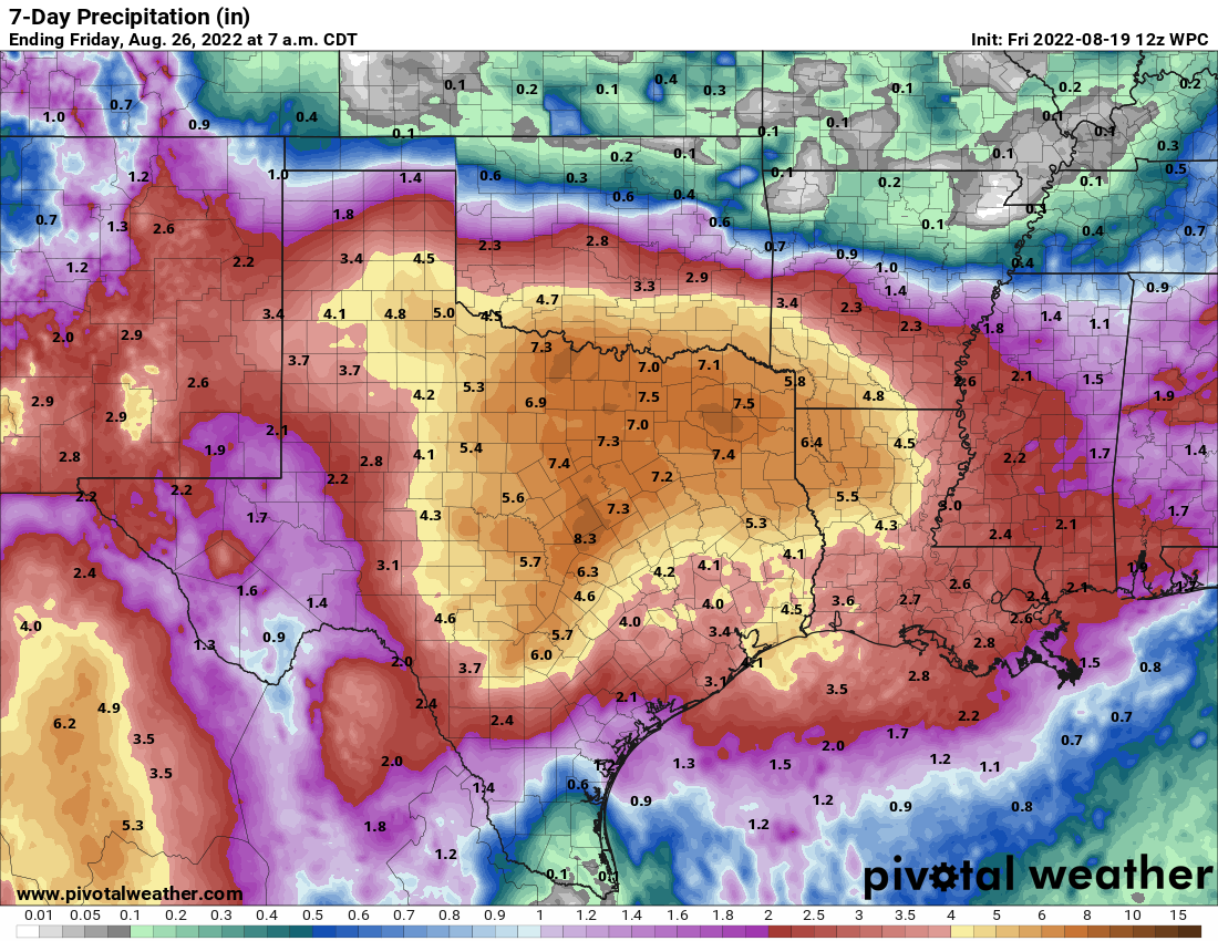
While the Houston area should see a bit less than other parts of the state, there’s still enough uncertainty in the forecast to think we have a chance at higher amounts, especially north and west of the city. Whatever the specifics, this is a big, big drought denter for the entire state of Texas. We’ll keep you posted as needed over the next few days.
yesterday’s rain forecast map for the afternoon was spot on.
I’m happy that Central Texas is finally getting some relief. When I was up there in May, the Pedernales was so dry you could walk across it and barely get your feet wet. They are due for some substantial rainfall.
Meh – can we not have it all at once? ah well, can’t have it perfect ever! 😀 thanks for the info!
ALL AT ONCE?!?!?!?!?!
You’re an idiot
“Noisy” is a very good word for yesterday evening’s and this morning’s storms. But, its noisiness was a good indicator that some welcome soaking was to start.
It is comforting to see the accumulation forecast (last graphic) will soak a good part of Texas to ease the drought for a bit.
As always, thanks to Matt and Eric for the continued no-hype weather reports!
Hopefully it won’t cause major flooding on the very Dry terrain.
Got 4″ in about two hours yesterday at my pecan orchard in Thompsons (due south of Sugar Land across the Brazos River).
Too late to save the crop – there will be no pecans this year – but this will help ease the stress on my trees and get the grass growing again.
Higher amounts possible north and west of the city next week? We’ll take it, hopefully it’s not too late for the hay yield we need for our livestock!
My 30 minute drive home last night to over 90, thanks to not being able to exit the Freeway and having to go several exits past the normal one, then while working my way back I get caught in the apartment fire (weather-caused) traffic and had to head back south again.
When people ask me why I’m leaving Houston when I retire, the easy answer is “the climate” (among other things).
Oh, yes, killed my first mosquito in many months during the morning walk today. They’re baaaack……
Not only the climate, but without zoning laws, the city is down right ugly, from IAH, down Will Clayton, south on I-69 to downtown and beyond….ugly!
It really gives first time visitors a good impression of the city!
It’s beautiful
There are so many great things about our city! Such diversity, friendliness and opportunities. I feel that the climate has something to do with the friendliness. After all every one of us walks out the door in the morning and gets soaked from the humidity. Hard to put on airs when everyone is brought down to earth by that. Such a smart group of people, too. From NASA to the energy corridor to the medical center to the refinery areas. And the restaurants! Did I mention the restaurants?
Yes, we need better transportation but at least we have freeways built for capacity. (Austin, I’m looking at you.) Also we’re blessed by (at least) four people who give us no-hype weather information. I like H-Town. Maybe it’s Stockholm Syndrome but it’s MY Stockholm Syndrome, haha!
Four people being Eric, Matt, Maria and Lee.
I was born in Houston, TX and I’ve lived in the surrounding areas all of my life. Yeah the weather sucks and its ugly, so don’t live here. Go back to wherever you call “home.”
Zoning isn’t the answer ,be grateful u don’t have zoning or code enforcement.because im in a little town and they are banning gravel driveways and if u park on dirt like many of us do that is proposed to become illegal soon . Zoning is just another way to control the people. Sure some take advantage of lackluster zone enforcement or no code but which would u rather have the iron fist telling you what kinda driveway u can have or the freedom to do as u please on ur property? If u say zoning move away dont try and bring what u desire to the area. Im sure denver or California has lots of communist areas u can live in!!! Leave Texas alone
calm down stranger, this is a weather site