Well, we sure didn’t start the holiday week on a bright and cheerful note, as Monday was a December or January-like gray Southeast Texas day. We will have a much brighter day today before we head into the holiday weekend with some low-impact unsettled weather to discuss post-Thanksgiving.
Today & tonight
Skies have mostly cleared out across the area, with the exception of a few spots south of I-10, as of about 5:30 AM. Expect those locations to clear out also, and we’ll have a mix of sun and just a few clouds in the area today. It will feel world’s warmer versus yesterday. Monday struggled to hit 50°, but today we should have no issues getting into the low-60s for high temperatures. Clear skies will continue tonight. Look for overnight lows to range from the low-40s northwest of Houston to the mid-40s in Houston and the upper-40s southeast of town.
Wednesday
The good news: If you’re traveling around the region on Wednesday, it should be mostly uneventful. There will be some low clouds or light rain and drizzle that materializes in the afternoon, mainly in East Texas. So just be prepared for some wet roads if traveling anywhere from Houston late. But any meaningfully significant rain will develop overnight and mainly over the open offshore waters of the Gulf of Mexico or east into Louisiana.
If you’ll be traveling outside of the region on Wednesday, there shouldn’t be a ton of issues to deal with.
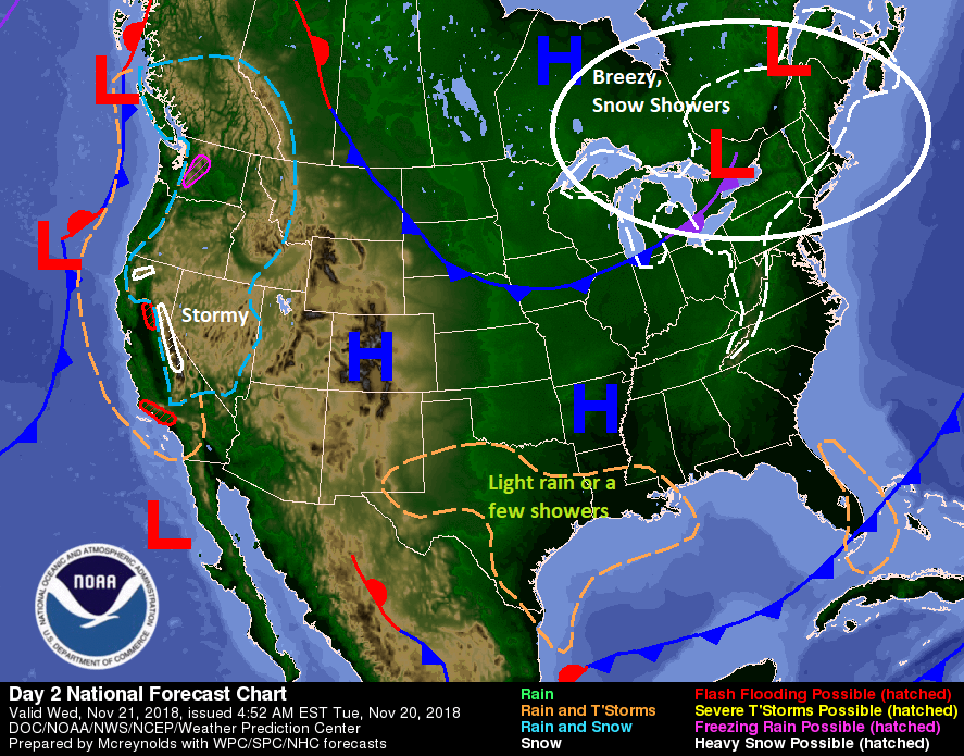
There will be snow showers and some gusty winds in the Northeast, so if you’re flying toward New England or the New York City airports, that could give you a delay. Atlanta and Chicago both look good Wednesday, so a couple trouble-free hubs will help matters. There will be no issues in Denver, but a storm bringing much needed rains to California may cause some issues at San Francisco or Sacramento. Overall, this is an acceptable travel day forecast.
Bringing it back locally, we’ll see clouds gradually increase during the daytime. Some light rain, drizzle, or a few showers may develop toward evening and that would continue into Wednesday night.

Thanksgiving Day
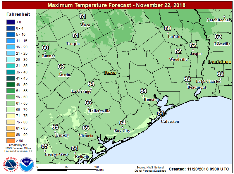
The system that will bring us some showers late Wednesday will develop into a potent little disturbance over the Gulf overnight and into Thursday morning. Fortunately, it will continue streaming away from our area, leaving us to deal with just some cloud cover on Thanksgiving Day. I’m not optimistic we’ll clear out substantially behind Wednesday night’s system, so we’ll call Thursday partly to mostly cloudy but it really shouldn’t be a bad day. It will feel a little like a Thanksgiving should, with high temperatures probably struggling into the lower or middle 60s.
If you’ll be running a Thanksgiving morning turkey trot, we’d expect some cool weather with upper-40s or low-50s in most of the area.
Friday
Another quick moving disturbance forms on Friday over East Texas. Unlike Wednesday night’s disturbance, this one should track further onshore, bringing a good chance of rain and perhaps a few thunderstorms to our area. Fortunately, it looks like this one will also not really get organized until it works into Louisiana, so at this point we are not concerned about heavy rain or severe weather. But we’ll keep tabs on it regardless. Look for a warmer day Friday. We’ll start in the low-50s and warm to about 70 degrees or so.
Weekend
Right now, Saturday looks warm and dry. Expect temperatures to warm from the low-50s into the low-70s on Saturday afternoon. We will call it partly sunny. A cold front is expected to sweep through the area Sunday. Right now, it doesn’t appear to have a lot of moisture to it until it gets into Louisiana. That means it should be a mostly uneventful frontal passage as it stands right now. I’d expect upper-60s or even some 70s again Sunday depending on the timing of the front, but we’ll probably drop deep into the 40s Sunday night. If you’ll be traveling back to Texas from out of the area, there could be some headaches to deal with. Details are uncertain on exactly what and where, but a potential winter storm will be tracking across Missouri and Iowa and into Illinois, so be aware of the forecast between Houston and there.
Look for chilly temps to start next week, with another night of 30s possible in the region, though probably above freezing this time. We will keep you posted.
I have an outdoor event Monday, November 26th at noon- I’m so anticipating your forecast!
Cold and breezy but otherwise decent is the call right now!
I read your weather first thing in the morning. You are more accurate than weather I see on then news. Where is the website I can get a shirt to support this site. And by the way you both have a sense of humor with your writing.
My birthday is the 30th. I’m hoping you can predict a nice forecast.
https://www.customink.com/fundraising/scw2018