We’ve reached Sept. 24th, the date after which it is quite rare for Texas to get struck by a hurricane. And as we’ll discuss below, with a few caveats, we expect that Texas is done with hurricanes this year as well. But first, let’s get to a wet forecast.
Monday
After Saturday night’s surprising cold front passage, Houston enjoyed drier conditions on Sunday, and that should be the case today as well as most of the moisture remains to the east of the region, off the coast and over Louisiana.
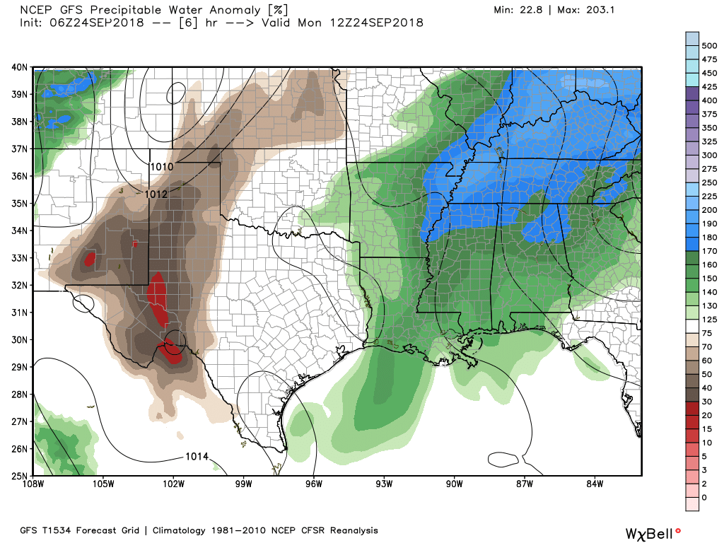
As a result, we can probably expect partly sunny skies today, with high temperatures near 90 degrees, and only some isolated showers and thunderstorms this afternoon. The (slightly) drier air ushered into the region by Saturday’s weak front will probably hang around through most of day and this evening before being washed away by returning Gulf of Mexico moisture.
Tuesday
Gulf moisture should begin returning Monday night and Tuesday, and while this won’t have too much of an effect on temperatures, we should see rain chances creep back up to the 30 to 40 percent range, with a corresponding increase in humidity.

Wednesday and Thursday
Higher rain chances should move into the Houston region during the middle of the week. We generally expect these to be mostly cloudy days, with widespread showers and thunderstorms for the region. Two-day rainfall totals probably will be in the vicinity of 0.5 to 2.0 inches for most people, with the characteristic variability we often see across the area. We don’t have any specific flood concerns at this time. Highs should be in the upper 80s.
Friday, Saturday, and Sunday
The weather for the end of this week will be determined by how far a cold front pushes into southeast Texas. As we saw this past weekend—when we thought a front would stall out over Houston rather than pushing all the way through—it is difficult to determine how far dying fronts will actually get during the early fall season. Therefore, the weather this weekend could range anywhere from continued showers and thunderstorms as a front stalls near Houston to the drier weather we saw this past Sunday. Right now I’d lean toward the rainier and more humid forecast, but I’m not giving up on the front yet.
Tropics
Bill Read, a friend, and the former director of the Houston/Galveston office of the National Weather Service and National Hurricane Center, used to tell me that he breathed easily in regard to Texas hurricanes after the “second cold front.” Clearly, Houston hasn’t yet gotten its second cold front of the 2018 fall season.
However, the fact remains that, after this calendar date, only three hurricanes have made a direct landfall in Texas over the last 150 years. Moreover, the Gulf of Mexico looks quiet over the next week or 10 days, which gets us into early October. Therefore, whereas we can’t rule out a tropical depression or lots of tropical moisture during the next several weeks, we are pretty confident that no hurricanes will be moving into the state this year. We’ll be 100 percent confident when we get a second, stronger cold front, but that may not happen for another 10 days or so.
Even though it’s far out, I’m a bit concerned about Kirk since some models have it aimed at the Gulf. Statistically speaking Florence was also the exception hitting US mainland from that far north
Are you referring to the remnants of Kirk as Kirk is no more
I thought it was Spock who died, but he came back in the next movie.
This comment made me lol!!!
Khaaaaaaan!