Well, here we are. As we’ve been discussing all week, a wet Labor Day Weekend is in the cards for the Houston area, as we continue to chip away at our drought and rainfall deficit all across Texas. Yesterday’s Drought Monitor report had mostly good news for Texas, with the most severe drought coverage losing about half its area, as well as improvements across the state too.
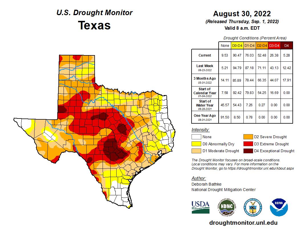
In our area, the only real coverage of extreme drought is west of Katy as of Tuesday, areas that have seen as much as 2 to 3 inches or so of rain since. Next week’s map should be even less ugly, as we expect multiple rounds of showers and storms across much of the southeastern third of Texas over the next few days.
Today
Much like yesterday, we should see some showers and storms pop up across the area during the afternoon, probably along the Highway 59 corridor after lunch and erratically expanding as the day progresses. Some areas will see nothing today, while others could quickly pick up an inch or two of heavy rain and see some ponding or street flooding. Highs will be near 90 degrees. Showers may linger for a couple hours after sunset before fading away.
Saturday and Sunday
With a weak cool front in our area this weekend and available moisture in the atmosphere running about 150 percent of normal, we have a very good recipe for numerous showers and thunderstorms and potentially heavy rainfall. If you have Saturday morning plans, you may be able to escape with minimal disruption, but after 9 or 10 AM, showers should begin to pop up from Houston and points south and east. The earlier you can accomplish things, the better. Storms will become more numerous in coverage on Saturday afternoon.

Stick a pin over downtown Houston. Areas south and east of that pin will likely see the most coverage of rain and storms. Coverage should be pretty healthy north and west of there as well, but it may be more scattered or intermittent.
For Sunday, look for a continuation of things. Showers and storms will blossom as the morning progresses and expand across much of the area. Sunday’s forecast is a bit trickier, however, in that the front may sag a bit farther south than Saturday. This could perhaps focus more of the rain farther south of I-10 and along the coast. We’ll update you this weekend on that.
Any storms this weekend will be capable of producing frequent lightning, brief strong wind gusts, and 2 to 3 inches of rain in an hour or a bit more. This will likely lead to occasional areas of street flooding anywhere in the Houston area or along the coast. For now, no flood watch or SCW flood alert is posted, but we will be monitoring things this weekend to see if that needs to change. Bottom line: Assume that if you’re under torrential rain, it will stay there a bit and could flood the streets for a time.

We are expecting about 1 to 3 inches of rainfall through Monday morning across the area. Important: On average. Some places will almost certainly see less, while others could easily see 4 to 6 inches of rain or even a bit more, depending on exactly how things setup. At this time, we expect those bullseye areas to be relatively small geographically, but we are not sure exactly where those will occur.
Clouds and showers will keep temperatures down this weekend, and at best we will probably see mid-80s for highs and 70s for lows.
Labor Day
If it does not happen on Sunday, the better support for storms should shift south of Houston on Monday, but I still do think we’ll have some rainy periods to contend with even in the city and north. I wouldn’t postpone outdoor plans, however. We’ll keep you posted this weekend. High temperatures should be mid to upper-80s, with lows in the 70s.
Rest of next week
While no days look to be washouts, we will probably deal with daily showers and storms most of the rest of next week. Temperatures should be fairly steady in the upper-80s to low-90s most days, with humid mornings in the 70s.
Tropics
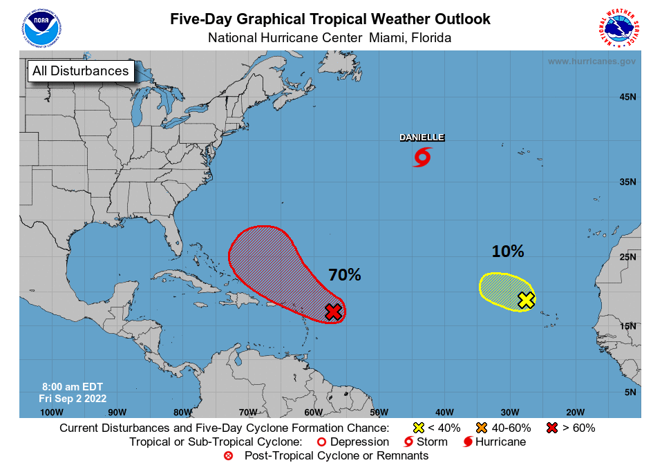
The good news: We have no concerns in the Atlantic for Texas. Tropical Storm Danielle formed yesterday, and it is destined to become a hurricane later today. Naturally, it’s occurring right where we all expe—oh, way up in the far northern Atlantic Ocean. Okay then. None of the other waves being monitored in the Atlantic by the National Hurricane Center are expected to get into the Gulf.
The intrigue: A tropical wave designated as “Invest 93E” in the Pacific off the south coast of Mexico is expected to develop into a tropical storm or hurricane in the coming days. It will curve north and toward Baja, and its leftovers should eventually end up over Mexico and either the desert Southwest or perhaps Texas. Obviously it won’t be a hurricane at that point, but we don’t know exactly how that system will impact our rain chances later next week or weekend, if at all. But options ranging from higher rain chances to very low rain chances, or even some scattered strong thunderstorms are on the table.
We probably won’t get much visibility on this until early next week. We’ll keep you posted.


Awesome, thanks for the update Matt!
Let it rain, it’s a sports weekend – college football and the medal round of the women’s world hockey championship (USA, Canada, Switzerland, and Czech Republic).
I need some Astros wins, Phillies wins, a Rutgers win, and Brighton over Leicester. 🙂
I used to believe that your ‘No Hype’ weather was real. You’ve been saying for days that we will get rain, but we get nothing. Supposed to have all these inches of rain, but nada. For us, how is your forecast any better than the crap we get from the local weather folks? Sounds like HYPE to me.
It’s a forecast, nobody gives guarantees on the weather.
About 95% of the Houston area has received at least a half-inch of rain over the last week, with most places seeing more than that. As we say constantly, the nature of rain in the summer in the Houston area is such that some people will see less rain than advertised and others much more. That’s simply how it is, and no forecaster can get around that. A 60% chance of rain for 10 days in a row means that on any given day, there’s a 60% chance it will rain in your backyard. Or a 40% chance that it will not. Sometimes the numbers don’t hit, so sorry you’ve been the 5% that’s gotten hosed. But this comment is misleading on a number of levels.
Not sure where you live Bob, but I’ve gotten afternoon showers every day this week!
No hype, I’ve gotten rain nearly everyday for 2 weeks. Just because they say anything area is supposed to get rain doesn’t mean every single spot in that area gets it.
What is the giant rotation near the UK??
Shows a clear “wall” on radar app.