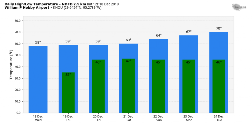
Temperatures have fallen to freezing levels this morning at some locations, including The Woodlands and Sugar Land, while remaining just above freezing in downtown Houston and closer to the coast. In short, it’s a cold morning, but at least the winds have died down across the region. It will feel like winter for a few more days before a warming trend next week.
Wednesday
Today will be a pleasant winter-like day for the region, with highs generally in the upper 50s under mostly sunny skies. Winds will be calm, to just a few mph out of the north. Low temperatures Wednesday night will probably be a couple of degrees warmer than Tuesday night, but a light freeze remains possible for inland areas. Venus is brilliant in the evening sky—be sure and check it out after sunset.
Thursday
Another mostly sunny day, although as light winds shift to come from the east we may begin to see development of a few clouds during the afternoon. Highs will likely rise to around 60 degrees for most of the region. This changing flow, along with additional cloud development, should keep lows in the 40s on Thursday night.
Friday
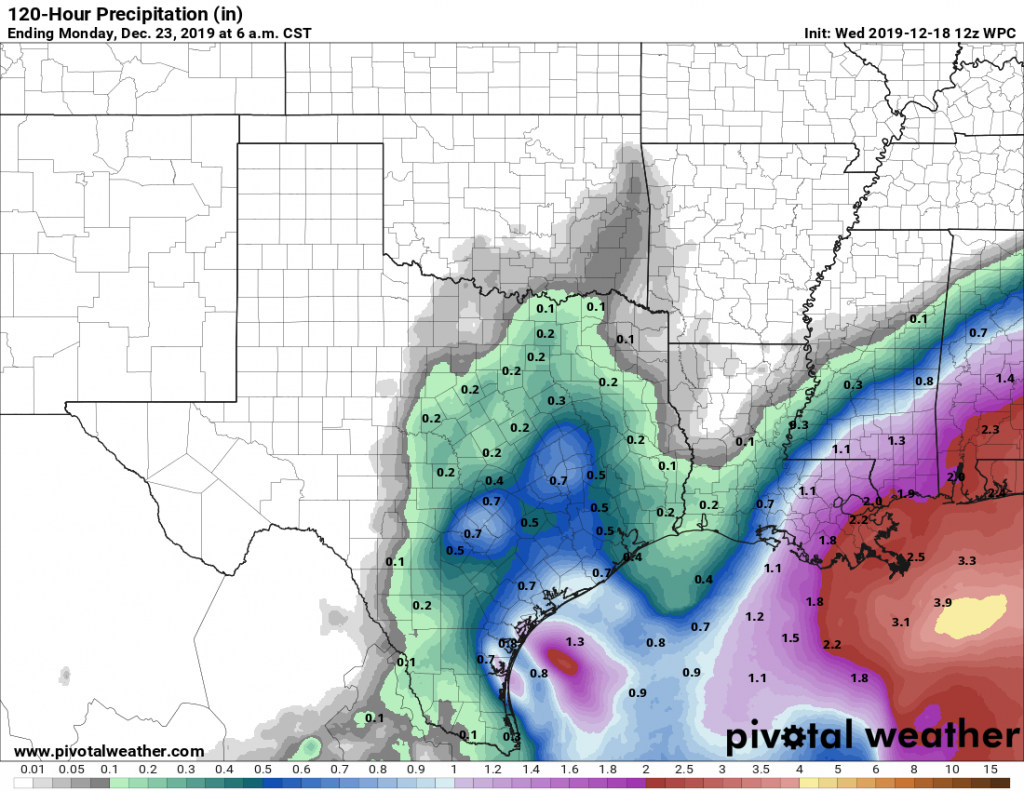
This should be a gray and fairly gloomy day. There will be a couple of impulses for rain—the first during the day with rising moisture levels, and the second early on Saturday morning as an upper level system drags a front through the region. Accumulations look quite modest in Houston, as most of the region probably will see about one-half inch of rain, or less. Regions near Matagorda Bay could see as much as 1 inch. Highs Friday will reach about 60 degrees.

Saturday
Temperatures Saturday morning will begin in the 40s, and rise to near 60 degrees as skies clear out, and we should have a pretty nice afternoon. Overnight lows should again drop into the 40s.
Sunday
This aptly named day should see lots of sunshine, dry air, and highs in the mid-60s. Lovely!
Christmas week
The mostly sunny skies will continue on Monday and Tuesday, with pleasant days in the 60s to possibly 70 degrees, and overnight lows mostly in the 40s. However, as the onshore flow gets going by Monday or so, that will set up warmer, and probably a bit muggier air by midweek and Christmas Day. For the holiday, expect daytime temperatures somewhere in the low 70s. At this point I’d bet on increasingly cloudy skies throughout the day, but confidence is not overly high in that. Rain chances look very low for Christmas Day, but not entirely zero.
This warming trend will probably continue at least into the weekend before a stronger front arrives, perhaps on Saturday or Sunday.
In the last 10 years, how many Christmas days have been “cold”?
Not many that I remember in recent years.
“Cold” is a subjective measure. Define cold as “less than x deg”. For many here, <70 is “cold”. For me, personally, I say <40 is “cold” for daytime temps. That’s a hard one to pin down. You could look at HOU or IAH climatology for December 25th to get actual data for you “less than” question. This will give you the normal means and extremes by day for December: https://www.weather.gov/hgx/climate_iah_normals_dec
I was born and raised in Green Bay, WI. Cold is 0 to 32 degrees. Frigid is below zero. Anything above that is mild.
I personally would much rather have it be warm. I love sending pics playing golf on a nice warm day to my friends in Chicago “enjoying” the Christmas cold!
Here ya go…
https://www.wunderground.com/history/daily/us/tx/houston/KHOU/date/2018-12-25
Ah yes, 1983 – remember that one well. Saw -23F at my parents’ home then came back here to find the city had shut off the water to my subdivision. I had two broken pipes despite draining them before I left.
High of 27F in 1983. Nice. A balmy 13F that morning when kids woke up to open presents.
Well, definitely 2004 (although more than 10 years ago)…we got Christmas Eve snow! But you got me curious so I looked it up. In past ten years Christmas Day was cold/chilly in 2009, 2010, 2011, 2013, 2017.