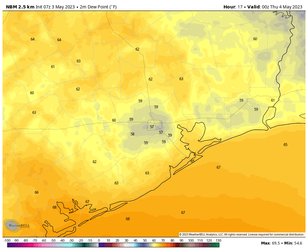
Some people don’t like to talk about dewpoints because they’re confusing. But they’re a really helpful way to quickly assess how stick the air will feel. The scientific definition of a dewpoint is the temperature to which the air must be cooled to achieve a relative humidity of 100 percent. So if the air temperature is 70 degrees—which may sound comfortable—and the dewpoint is also 70 degrees it’s going to feel really sticky outside. But you don’t have to remember that definition for dewpoints, just this handy guide:
Dewpoints in the mid-50s or below: The air is dry and comfortable
Dewpoints in the mid-60s: The air starts feels somewhat sticky during the day, and somewhat muggy in the evenings
Dewpoints in the mid-70s or higher: Oh my god I’m dying.
I am sorry to say that today, specifically the period from around noon to late afternoon, is going to be our last shot of dewpoints in the 50s for awhile. After today we’re looking at dewpoints in the upper 60s to lower 70s for the foreseeable future. While we may get a front to knock them back in 10 or more days, it is by no means a certainty. Welcome to May.
Wednesday
After some fog and clouds this morning, skies are going to clear out and leave us with a mostly sunny day. This, combined with the slightly drier air mentioned above is going to allow temperatures to pop up into the mid- to upper-80s. Winds will be slight, at 5 to 10 mph, generally from the southeast. Some clouds return tonight, but lows should drop into the mid-60s for all but coast areas. This probably will be our last night in the 60s for quite a while.
Thursday
As high pressure moves off, the region will open up to a more pronounced flow off the Gulf of Mexico. This will result in more humidity and clouds, to go along with high temperatures in the mid- to upper-80s. With increased moisture the region may see some scattered showers and thunderstorms on Thursday evening and overnight. The most likely areas for this will be north and west of the metro area, in places such as College Station and Conroe. I would not expect anything particularly severe. Lows on Thursday night will only drop into the 70s.
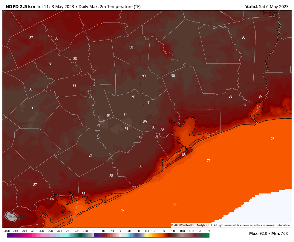
Friday, Saturday, and Sunday
This three day period will be hot and humid. Look for partly to mostly cloudy skies each day, with daytime highs around 90 degrees or slightly above. Rain chances are not zero, and there will probably be a few isolated showers each day. But if you’re planning outdoor activities things should be fine as long as you have plan for some temporary shelter. Which to be clear, probably won’t be needed. In addition to hot days, nights will be warm and sticky, with lows only dropping into the mid-70s.
Next week
The overall pattern does not change much next week. Daytime temperatures may drop a degree or two, but the humidity should remain more or less the same. Some better rain chances may pop up by the middle or end of next week. We’ll see.


The dewpoint guide is very helpful, but also a little trauma-inducing.
I agree that the dewpoint guide is very helpful and, with 3 levels, even a caveman can understand it.
Unfortunately, the Level 3 (“OMG, I’m dying”) stage is too frequently blinking around these parts.
The dew point is the point at which the air can carry no more moisture – tested by an hygrometer – and at which level the body cannot exchange any more moisture with the air – hence; sticky!
Blech.
Omg I’m dying lol I’ve never seen a more accurate description of Houston weather. Thank you for the smile!
Hope is not a tactic, right?
Well I’m thinking (hoping) that with the possible onset of El Niño, and the decent amount of spring rains so far, we may have an absence of the death ridge of high pressure that tortured us last summer. This may give us a rainy summer this making it somewhat tolerable this season.
Anyone cares to weigh in or thinks I’m dreaming, I will happily accept your rebuke.
I would just say there are alot of assumptions in your comment, weather is unpredictable and things may not go to what you want. Hope is good to have
I depend on your forecasts. My husband was a mederaligist (sp?) In the Air Force since he’s pasted away it’s nice to have y’all.
I am headed up to Thr Red River Monday. I go Katy to Waco the 281 on up to Saint Jo. It shows 50-60% chance of Tstorms on Accu weather. Do you agree? Thank you B
I think it depends where you live in or around “metro” if you got decent amount of spring rain. I still see cracks in the soil here inside the loop. The rain monitor at Hobby is still 20 inches below normal when adding the 2022 drought. So there’s a lot of catching up to do to stay within the 20 year normal. Or maybe that’s gone with the CC. Twitterland weather geeks are talking about increased easterlies in the Pacific this month that may speed up El Niño (warmer eastern Pacific, colder western). Hot and Humid can be tolerable with periodic rain showers. But the capping and high pressure ridges that don’t go away make it durn near uninhabitable in July and August if that happens again. We’ll see.
Ugh!!!
They should also do a post on enthalpy and how the energy in a thermodynamic system affects the moisture levels in the air, as well as the dew points.
For friends not acquainted with Houston humidity, I liken it to ‘living in a dog’s mouth.’
I comfort myself with ‘I almost never have to scrape ice off my windshield.’
Typically don’t set foot outside during the 8 months of Houston summer swamp weather as it’s just completely miserable, but that is good info.
It’s hard to believe but 10 years ago to this day we had a strong cold front blow through which brought highs down into the upper 60s. This was followed by a record low of 42 on May 4th 2013. That was truly a freak event for this area that late in the season. We actually had multiple unseasonably strong cold fronts throughout the entire spring of 2013. However that was soon followed by a record high of 107 on June 29th the same year. Which was the hottest June temperature observed in Houston. This is a good example of why the weather we see during the Spring holds no bearing on what the weather during the Summer season is going to be like.
Joseph did you get much rain where you are? I mostly post here I guess because the cap is “always over my house” and gardening is a pain. Houston city water is poison for plants. So always looking for folks to commiserate 😅All the great tropicals that grow here got zapped by the December deep freeze and I was still trying to recover from Valentine 21 deep freeze. I was here for the 2011 drought so I guess we’ve seen it all.